Earth Science 7-South America2
Earth Science 7-Global Regions Index
Contents
Countries
Brazil
Argentina
Chile
Peru
Bolivia
Guyana
Suriname
French Guyana
Ecuador
Colombia
Venezuela
Paraguay
Uruguay
Major Bodies of Water
Amazon
Orinoco
Negro
Xingu
Tocantins
Parana
Paraguay
Tapajos
Magdalena
Madeira
Sao Francisco
Rio De La Plata
Rio Uruguay
Lake Titicaca
Lake Maracaibo
Currents
The Antarctic Circumpolar Current passes the southern tip of South America, cooling the coast.
The Peru Current, also known as the Humbolt Current,the Peru Current is a surface current that brings fog to the nearby coast but also keeps the coast one of the most intensely arid areas in the world (except during El Nino). The coldness is intensified by the upwelling caused by the drag of southeastern trade winds. [5]
The Malvinas Current, also known as the Falkland current,is a surface current that is strong, relatively fresh, and cold, with average subsurface temperatures of 6°C.
[6]
The Brazil Current is a weak, surface current carrying warm subtropical water, which runs south along the coast of Brazil from about 9°S to about 38°S. The current has warm temperatures that vary from 66° to 81° F (19° to 27° C) and a high salinity that averages 35 to 37 parts per thousand.
[7]
The equatorial countercurrent, is an eastward flow of water, flowing the opposite direction and surrounded by the westward equatorial currents of the Pacific ocean. Between latitude 3° and 10° N, the countercurrents shift south during the northern winter and north during the summer. To either side the trade winds blow constantly and push great volumes of water westward in the equatorial currents.
[9]
Ice Cover
Ice masses cover roughly 4,900 square kilometers of southern South America, making a huge ice cap whose long tongues run into lakes or the sea. [10]
Tides
South America has fairly average tides. In the Amazon River, tidal bores, breaking waves that move upstream with the rising tide, can occur. [11]
Latitude and Longitude
The northern most point of South America is 12 degrees and 27 minutes North. The southern most point of South America is 55 degrees and 47 minutes South. The western most point of South America is 80 degrees and 53 minutes West, and the eastern most point of South America is 34 degrees and 51 minutes West.
Elevation Range
The highest elevation in South America is at Cerro Aconcagua, Argentina, which is 6,960 meters tall. It is part of the Andes Mountain Range. The lowest point in South America is the Laguna del Carbon, which is 105 meters below sea level, also located in Argentina.
Topographic Features
Amazon Basin
Andes Mountains
Angel Falls
Atacama Desert
Brazilian Highlands
Brazilian Shield
Cape Horn
Guina Highlands
Llanos (plain)
Pampas (plain)
Pantanal (wetlands)
Patagonia
Tierra del Fuego (archipelago)
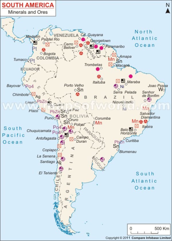
Rocks and Minerals
Many of South America's minerals are found in the Pampas plains.
South America has about 1/5 of the world's iron ore reserves. The most important of these beds are in Brazil and Venezuela.
Manganese occurs in sedimentary rock in Brazil and the highlands of Bolivia.
The copper in South America (mostly found in Chile's Atacama Desert and Peru's Andean mountain ranges) accounts for 1/4 of the world's copper reserves.
Bolivia is one of the top five tin producers in the world. These reserves are located in sedimentary deposits in Bolivia's eastern Andes. Significant deposits occur in the Amazon River basin.
Gold deposits occur in Colombia's Atrato River basin. In this river basin, sediments are deposited, and sedimentary rocks are formed.
There are many metamorphic rocks in the Northern Andes mountains. Belts in the Southern Andes contain lots of coarse-grained igneous rock.
In the Amazonas, Parnaíba, Paraná, and Chaco basins many deposits of sedimentary rocks are located.
Argentina- The major minerals and metals found in Argentina are boron, lithium, strontium, lead, zinc, tin, manganese, uranium, gold, silver, aluminum, copper, and potash.
Brazil- The major minerals and metals found in Brazil are iron ore, copper, gold, nickel, bauxite, phosphates, tantalum, platinum, tin, uranium, and manganese. Gemstones commonly found in this country are diamond, emerald, aquamarine, topaz, tourmaline, opal, chrysoberyl, amethyst, citrine, and agate.
Bolivia- The major minerals and metals found in Bolivia are tin, zinc, tungsten, antimony, silver, iron, copper, bismuth, tantalum, boron, lithium, lead, and gold.
Chile- The major minerals and metals found in Chile are molybdenum and iron ore. Chile has the second largest reserves of molybdenum in the world. [14]
Colombia- The major minerals and metals found in Colombia are iron ore, nickel, gold, copper, and emeralds.
Ecuador- Ecuador is not a major producer of minerals. It does produce manganese, silver, and gold in small amounts. Ecuadorian silver is mainly located in the Andes Mountains. The Tungurahua (Throat of Fire) volcano is located in Ecuador, and with this volcano comes igneous rocks.
French Guyana- The major minerals and metals found in French Guyana are gold deposits, kaolin, niobium, and tantalum.
Guyana- The major minerals and metals found in Guyana are bauxite, gold, and diamonds.
Paraguay- The major minerals, metals, and rocks found in Paraguay are iron ore, manganese, limestone.
Peru- The major minerals and metals found in Peru are copper, silver, gold, iron ore, phosphate, and potash.
Suriname- The major minerals and metals found in Suriname are kaolin, bauxite, gold, small amounts of nickel, copper, platinum, and iron ore.
Uruguay- No major minerals or metals are found in Uruguay.
Venezuela- The major minerals and metals found in Venezuela are iron ore, gold, bauxite, and diamonds. [15]

Bordering Oceans
Atlantic Ocean
Pacific Ocean
Caribbean Sea
Gulf of San Jorge
Gulf of San Matias
Gulf of Penas
Gulf of Paria
Gulf of Guayaguil
Strait of Magellan (Connects Pacific and Atlantic Oceans)
Climate
-Equatorial, fully humid: It is equatorial because it is near the equator. It is fully humid because it is surrounded by large bodies of water and it is in a low pressure area. It is located in the Amazon Rainforest, whose vegetation contributes to the humidity of this region through transpiration.
-Equatorial, monsoonal: It is equatorial because it is near the equator, resulting in higher temperatures. It is monsoonal because it is in an area of a seasonal prevailing wind and it is surrounded by water, causing the monsoon to carry water, hence the name, wet monsoon, which is followed by the rainy season.
-Equatorial, winter dry: It is equatorial because it is near the equator, and it is dry in the winter because it is in an area of low elevation, where there is high pressure and low humidity, and in the winter, it is colder and there is much less humidity.
-Warm temperate, fully humid, hot summer: It is fully humid because it is near the ocean and it has a lot of foliage. It is hot in the summer because the angle of insolation is stronger at that time and the humidity holds in the heat. It is warm and mild usually because of its location and winds.
-Warm temperate, fully humid, hot arid: It is fully humid and mild because it is in a low pressure zone, and it is near the ocean. It is hot arid because the rain is blown away because of the prevailing winds.
-Arid, steppe, cold arid: It is arid because, like many of the things in this section, it is in the rain shadow of the Andes Mountains, and it is cold because of colder temperature being pushed to it by very strong winds.
-Warm temperate, fully humid, warm summer: It is in a low pressure location surrounded by an ocean, resulting in it being mild and humid. It is warm in the summer because its angle of insolation is strong there and the water holds in the heat.
-Warm temperate, summer dry, warm summer: This region is between the 30 and 40 degrees south latitudes contributing to the warm, temperate temperatures. It in the rain shadow of the Andes Mountains, contributing to its dryness. This region is on the coastline resulting in more extreme temperatures.
-Polar, polar tundra: This region has a polar tundra climate because it is close to the south pole and is surrounded by water, making the temperatures more extreme. It is near a cold ocean current resulting in colder temperatures on the coastline.
-Arid, desert, cold arid: It is arid and cold because it is far away from the equator, it is in an area of high pressure, and it is in a mountain range. It is also in the rain shadow of the Andes Mountains. This also accounts for it being a desert.
-Equatorial, winter dry: This region is near the equator giving it warm temperatures. It is near a warm ocean current, giving the coast line warmer and more extreme temperatures. This region is near the ITCZ (intertropical convergence zone) resulting in wet and dry seasons instead of hot and cold seasons.
-Arid, desert, hot arid:
It is hot because it is in a high angle of insolation (because it is located near the equator). It is arid and a desert because it is in the rain shadow of the Andes Mountains.
-Arid, winter dry, hot arid: It is arid because it is a fair amount above sea level. It has low humidity in the winter because it is in high elevation and that is where low pressure is, and because it is not being warmed by the sun as much, it stays that way. It is hot arid because of it being in a mountainous area and that it is getting a fair amount of wind.

Tectonic Plates
The western and southern coasts of South America are active margins.The northern and eastern coasts are passive margins.
The majority of South America lies on the South American plate. The northwestern part of South America lies on the North Andes Plate, the central western portion lies on the Altiplano Plate, and the southern tip of South America lies on the Scotia Plate.
Where the Altiplano Plate interacts with the Nazca Plate is a oceanic-continental subduction boundary.
Where the Altiplano Plate interacts with the South American plate on the northwestern and southern sides is a continental rift boundary. Where the Altiplano Plate interacts with the South American plate on the northeastern side is a continental collision boundary with a small portion, transform.
Where the South American Plate interacts with the Scotia Plate is a continental transform boundary.
Where the South American Plate interacts with the Nazca Plate is an oceanic-continental subduction zone. The Andes Mountains are a volcanic mountain chain on the western coast of South America that formed at this boundary. Another result of this subduction is the Peru-Chile trench.
Where the South American Plate interacts with the African Plate is a divergent boundary. A result of this boundary is the Mid-Atlantic Ridge.
Where the North Andes Plate interacts with the Caribbean Plate is an oceanic-continental subduction boundary with oceanic transform faults, and a small portion of continental rift.
Where the North Andes Plate interacts with the South American Plate is a continental collision with continental transform faults.
Where the North Andes Plate interacts with the Nazca Plate is an oceanic-continental subduction boundary. Many volcanoes on the overriding North Andes Plate are located on this boundary.
Where the South American Plate interacts with the Caribbean Plate is a continental transform fault.
Where the North Andes Plate interacts with the Panama Plate is a continental collision boundary with continental transform faults.
Volcanoes
There are very many volcanoes in South America, almost entirely occurring the the Andes Mountains. The Andes Mountains is a volcanic mountain chain on the west coast of South America created by the subduction boundary on the west coast. The majority of the volcanoes in the Andes chain are composite cones, but shield and cinder cone volcanoes also occur in smaller numbers.
In 1991, the Cerro Hudson volcano erupted in Chile,in the largest eruption in South America in recent history. This eruption had a volcanic explosively index (VEI) of 5.
The most recent significant eruption occurred on June 4, 2011 when the Puyehue-Cordon Caulle volcanic complex in Chile erupted. This eruption produced a 5 km wide ash plume that rose 12.2 km. Pyroclastic flow deposits were observed, although lava was not detected. This eruption created a cloud of ash that stopped many flights.
There are no volcanoes currently on alert, but on April 16, 2012, observers in Manizales, Colombia reported a gas/steam plume that rose 1.8 km above the crater of the Nevado del Ruiz volcano. The alert level was orange (eruption likely within days or weeks.)
The Puyehue-Cordon Caulle volcanic complex in Chile showed plumes almost daily April 11-17. Incandescence was reported on April 10 and 11. The alert level was also at orange.
On April 11, an ash plume rose 5 km above the crater of the Tunguruahua volcano in Ecuador. An explosion on April 12 was followed by ashfall in multiple areas.
Ash was ejected from Villarrica, a volcano in Chile, on April 9 and incandescence came from the crater at night.
Historic Volcano Eruptions:
- February 1600- Huaynaputina VEI- 6
- October 1660- Guagua Pichincha VEI-4
- May 1744- Cotopaxi VEI-4
- December 1762- Peteroa VEI-4
- April 1768- Cotopaxi VEI- 4
- January 1877- Cotopaxi VEI-4
- January 1886- Tungurahua VEI-4
- January 1893- Calbuco VEI-4
- November 1897- Dona Juana VEI-4
- 1916- Cerro Azul VEI-5+
- March 1916- Tungurahua VEI-4
- July 1955- Carran-Los Venados VEI-4
- June 1968- Fernandina VEI-4
- May 2008- Chaiten VEI-4
Volcanoes in the Andes Mountain Range include:
- Cerro Bravo
- Nevado del Ruiz
- Santa Isabel
- Nevado del Tolima
- Machin
- Nevado del Huila
- Purace
- Sotara
- Petacas
- Dona Juana
- Galeras
- Cumbal Azufral
- Cerro Negro de Mayasquer
- Soche
- Reventador
- Cayambe
- Cuicocha
- Pululagua
- Mojanda
- Sumaco
- Pan de Azucar
- Guagua Pinchincha
- Atacazo
- Cotopaxi
- Illiniza
- Quilotoa
- Chacana
- Chimborazo
- Tungurahua
- Quimsachta
- Nevados Firura
- Andahua Valley
- Coropuna
- Nevado Chachani
- El Misti
- Ubinas
- Huaynaputina
- Ticsani
- Tutupaca
- Yucamane
- Nevados Casiri
- Tacora
- Nevado Anallajsi
- Patilla Pata
- Parinacota
- Acotango
- Taapaca
- Guallatiri
- Cerro Colluma
- Sacabaya
- Arintica
- Tata Sabaya
- Cabaray
- Isluga
- Puchuldiza
- Cerro Pina
- Laguna Jayu Khota
- Nuevo Mundo
- Irruputuncu
- Unnamed
- Pampa Luxsar
- Olca-Paruma
- Aucanquilcha
- Ollague
- Cerro San Agustin
- Cerro Yumia
- Cerro del Azufre
- Escala
- Cerro Santa Isabel
- San Pedro
- Paniri
- Jorcada
- Quet
- Cerro del Leon
- Linzor
- Cerro Moiro
- El Volcan
- Uturuncu
- Quetena
- El Tatio
- Cerros de Tocorpuri
- Putana
- Sairecabur
- Licancabur
- Guayaques
- Purico Complex
- Laguna Verde
- Colachi
- Acamarachi
- Lascar
- Chiliques
- Miniques
- Cordon de Puntas Negras
- Tilocalar
- Cerro Tujle
- Caichinque
- Cerro Tuzgle
- La Negrillar
- El Negrillar
- Pular
- Aracar
- Socompa
- Llullaillaco
- Lastarria
- Unnamed
- Cerro Escorial
- Cordon del Azufre
- Cerro Bayo
- Antofalla
- Antofagasta de la Sierra
- Sierra Nevada
- Cerro el Condor
- Peinado
- Robledo
- Falso Azufre
- Nevado de Incahuasi
- Tipas
- El Solo
- Copiapo
- Nevados Ojos del Salado
- Tupungatito
- San Jose
- Maipo
- Caldera del Atuel
- Palomo
- Risco Plateado
- Tinguiririca
- Planchon Peteroa
- Calabozos
- Descabezado
- Cerro Azul
- Laguna del Maule
- San Pedro-Pellado
- Nevado de Longavi
- Lomas Blancas
- Domuyo
- Payun Matru
- Cochiquito Volcanic
- Resago
- Domuyo
- Nevados de Chillan
- Tromen
- Antuco
- Puesto Cortaderas
- Trocon
- Antuco
- Callaqui Copahue
- Tolguaca
- Laguna Marinaqui
- Lonquimay
- Llaima
- Sollipulli
- Caburgua-Huelemolle
- Villarrica
- Lanin
- Quetrupillan
- Huanquihue Group
- Mocho-Choshuenco
- Mencheca
- Carran- Los Venados
- Cordon Caulle
- Antillanca Group
- Cerro Pantoja
- Cordon Cenizons
- Osorno
- Cerro Volcanico
- Cuernos del Diablo
- Yate
- Hualiaque
- Hornopiren
- Huequi
- Chaiten Minchinmavida
- Corcovado
- Yanteles
- Palena Volcanic Group
- Melimoyu
- Puyuhuapi
- Mentolat
- Cay
- Maca
- Cerro Hudson
- Lautaro
- Viedma
- Aguilera
- Reclus
- Monte Burney
- Palei-Aike Volcanic Field
- Fueguino
Earthquakes
Most earthquakes in South America occur on the west coast. The magnitude of these earthquakes range from 6 to 8. The depth of these earthquakes can be as deep as 650 kilometers and as shallow as 5 kilometers. The deeper earthquakes are farther away from the plate boundary. In 1945, in the Atacama Desert, an earthquake occurred with a magnitude of 8 and a depth of 45 kilometers. The earthquakes occur on plate boundaries and near volcanic ranges. The most common earthquake magnitude is 6.1. There are few earthquakes along the Northern coast of South America. The earthquakes in that area occur because of the other plate boundary, the Caribbean Plate.
The last major earthquake occurred in Chile, on February 27, 2010. This earthquake had a moment magnitude of 8.8. [27]
As of the 22nd of April, 2012, there have been 2 earthquakes that occurred on that day, both on the West coast. Their magnitudes were 4.4 and 4.6. In the past week as of the 22nd of April, 2012, 7 earthquakes occurred on the mainland, not including the 2 that occurred on the day. The highest magnitude of this batch was a 6.7.
[28]
South America had the largest earthquake recorded since 1900. In Chile, on May 22, 1960, an earthquake occurred with a magnitude of 9.5. This earthquake had 4 foreshocks before it, all above a magnitude of 7. 5 aftershocks occurred, all of which had a magnitude of 7 or higher. Tsunamis from this earthquake caused damage in places other than South America. The Tsunamis had notable effect on Japan, the West coast of North America, Hawaii, the Philippines, and other locations in, or near, the Pacific. Although the largest, this earthquake was not the deadliest.
[29]
References
Google Earth
http://www.worldatlas.com/webimage/countrys/sa.htm (great website for maps of any kind, see below)] [1]
http://www.enchantedlearning.com/geography/samer/riveroutlinemaplabeled/ (great website for research, I used it a lot at AOS) [2]
http://www.worldatlas.com/webimage/countrys/saland.htm [3]
https://www.cia.gov/library/publications/the-world-factbook/geos/ar.html (tons of information) [4]
http://ic.galegroup.com/ic/suic/?userGroupName=tlc209178764 [5]
http://www.ngsednet.org/community/resource_uploads/Eye%20on%20South%20America.pdf (small amount from source) [6]
http://www.worldatlas.com/webimage/countrys/samerica/samera.htm [7]
http://www.geo.hunter.cuny.edu/~fbuon/PGEOG_334/Literature_pdfs/coasts_ch11.pdf [8] http://koeppen-geiger.vu-wien.ac.at/present.htm [9]
http://www.britannica.com/EBchecked/topic/453262/Peru-CurrentM [10]
http://oceancurrents.rsmas.miami.edu/atlantic/malvinas.html [11]
http://www.oceanmotion.org/html/background/wind-driven-surface.htm [12]
http://www.britannica.com/EBchecked/topic/78307/Brazil-Current [13]
http://www.britannica.com/EBchecked/topic/555844/South-America/41821/Resources?anchor=toc41822 [14]
http://minerals.usgs.gov/minerals/pubs/country/sa.html#br [15]
https://www.cia.gov/library/publications/the-world-factbook/fields/2111.html [16]
http://www.mapsofworld.com/south-america/minerels-and-ores.html [17]
http://www.geo.arizona.edu/geo5xx/geo527/Andes/tectonicandes.html [18]
http://www.britannica.com/EBchecked/topic/190653/equatorial-countercurrent [19]
http://www.britannica.com/EBchecked/topic/555844/South-America [20]
http://www.volcano.si.edu/world/region.cfm?rnum=15&rpage=list [21]
http://volcano.oregonstate.edu/education/facts/veiTables/s_america.html [22]
http://www.volcano.si.edu/world/volcano.cfm?vnum=1507-15=&volpage=weekly [23]
http://www.volcano.si.edu/reports/usgs/ [24]
http://www.volcano.si.edu/world/region.cfm?rnum=15&rpage=erupt [25]
http://www.volcano.si.edu/world/region.cfm?rnum=15&rpage=list [26]
http://www.uwgb.edu/dutchs/platetec/topten.htm [27]
http://earthquake.usgs.gov/earthquakes/recenteqsww/Maps/region/S_America.php [28]
http://earthquake.usgs.gov/earthquakes/world/events/1960_05_22.php
[29]
Cite error: <ref> tags exist, but no <references/> tag was found