Difference between revisions of "Earth Science 7-Alice Springs, Australia"
| (17 intermediate revisions by 2 users not shown) | |||
| Line 5: | Line 5: | ||
; Latitude/ Longitude : 23 degrees 42 minutes S/ 133 degrees 52 minutes E <ref name="Google Earth">Google Earth, 2010, Alice Springs, Australia</ref> | ; Latitude/ Longitude : 23 degrees 42 minutes S/ 133 degrees 52 minutes E <ref name="Google Earth">Google Earth, 2010, Alice Springs, Australia</ref> | ||
| − | ; Elevation : 580.3392 meters <ref name"Google Earth"> | + | ; Elevation : 580.3392 meters <ref name="Google Earth"/> |
| − | ; Large Body of Water : Todd River <ref name"Google Earth"> | + | ; Large Body of Water : Todd River <ref name="Google Earth"/> |
| + | |||
| − | |||
| − | |||
| − | |||
| − | |||
| − | |||
| − | |||
http://www.outback-australia-travel-secrets.com/image-files/alice-springs-pictures-2.jpg | http://www.outback-australia-travel-secrets.com/image-files/alice-springs-pictures-2.jpg | ||
| + | |||
| + | |||
| + | =='''Climate'''== | ||
| + | |||
| + | ===''Climate Zone''=== | ||
| + | |||
| + | BWH (desert or arid) on the Koppen Classification Chart | ||
| + | <ref>http://www.uwmc.uwc.edu/geography/100/koppen_web/koppen_map.htm</ref> | ||
| + | |||
| + | This city has a similar climate to Lima, Peru [[Earth Science 7-Lima, Peru]] | ||
| + | |||
| + | |||
| + | http://www.outback-australia-travel-secrets.com/image-files/alice-springs-pictures-3.jpg | ||
| + | |||
| + | ===''Average Temperature''=== | ||
| + | {|border="1" cellpadding="5" | ||
| + | |- | ||
| + | ! scope="col" | | ||
| + | ! scope="col" | Jan. | ||
| + | ! scope="col" | Feb | ||
| + | ! scope="col" | Mar. | ||
| + | ! scope="col" | Apr. | ||
| + | ! scope="col" | May | ||
| + | ! scope="col" | June | ||
| + | ! scope="col" | July | ||
| + | ! scope="col" | Aug. | ||
| + | ! scope="col" | Sept. | ||
| + | ! scope="col" | Oct. | ||
| + | ! scope="col" | Nov. | ||
| + | ! scope="col" | Dec. | ||
| + | |- | ||
| + | |Average Temp. (C˚) | ||
| + | |28 | ||
| + | |27 | ||
| + | |25 | ||
| + | |20 | ||
| + | |15 | ||
| + | |12 | ||
| + | |11 | ||
| + | |14 | ||
| + | |18 | ||
| + | |22 | ||
| + | |25 | ||
| + | |27 | ||
| + | |- | ||
| + | |Average. High (C˚) | ||
| + | |36.4 | ||
| + | |35.0 | ||
| + | |32.7 | ||
| + | |28.2 | ||
| + | |23.0 | ||
| + | |19.8 | ||
| + | |19.7 | ||
| + | |22.6 | ||
| + | |27.2 | ||
| + | |30.9 | ||
| + | |33.6 | ||
| + | |35.4 | ||
| + | |- | ||
| + | | Average Low (C˚) | ||
| + | |21.4 | ||
| + | |20.8 | ||
| + | |17.5 | ||
| + | |12.6 | ||
| + | |8.3 | ||
| + | |5.1 | ||
| + | |4.0 | ||
| + | |6.0 | ||
| + | |10.3 | ||
| + | |14.8 | ||
| + | |17.8 | ||
| + | |20.2 | ||
| + | |} | ||
| + | |||
| + | |||
| + | |||
| + | ===Average Precipitation=== | ||
| + | |||
| + | {|border="1" cellpadding="5" | ||
| + | |- | ||
| + | ! scope="col" | | ||
| + | ! scope="col" | Jan. | ||
| + | ! scope="col" | Feb. | ||
| + | ! scope="col" | Mar. | ||
| + | ! scope="col" | Apr. | ||
| + | ! scope="col" | May | ||
| + | ! scope="col" | June | ||
| + | ! scope="col" | July | ||
| + | ! scope="col" | Aug. | ||
| + | ! scope="col" | Sept. | ||
| + | ! scope="col" | Oct. | ||
| + | ! scope="col" | Nov. | ||
| + | ! scope="col" | Dec. | ||
| + | |- | ||
| + | |Average Precipitation (mm) | ||
| + | |38.6 | ||
| + | |43.4 | ||
| + | |31 | ||
| + | |16.6 | ||
| + | |19 | ||
| + | |14 | ||
| + | |15.3 | ||
| + | |9.4 | ||
| + | |8.6 | ||
| + | |21.1 | ||
| + | |28.2 | ||
| + | |37.1 | ||
| + | |- | ||
| + | | Average Snowfall (mm) | ||
| + | | Snow Happens Occasionally in the Winter Season, when it rains, but not enough to gather a conclusive data chart. | ||
| + | |} | ||
| + | |||
| + | |||
| + | ===Pressure=== | ||
| + | |||
| + | Alice Springs is a primarily high pressure area. This means that the weather is mostly hot because of the wind coming from the south. | ||
| + | |||
| + | |||
| + | ===Factors that Regulate Climate=== | ||
| + | |||
| + | |||
| + | Alice Springs is on the banks of the Todd River which regulates the temperature all year. It is a desert climate that is raised considerably off sea level. It is considered a pleatueu, a mostly flat area and that increases the temperature. | ||
| + | <ref>http://www.bom.gov.au/climate/averages/tables/cw_015590.shtml<ref> | ||
| + | |||
| + | <ref>http://www.weatherbase.com/weather/weather.php3?s=062349&refer=</ref> | ||
| + | |||
| + | |||
| + | =='''Geology'''== | ||
| + | |||
| + | ===''Tectonic Plate Boundary Near Alice Springs''=== | ||
| + | Alice Springs is situated on the Australian Plate about 3093 km (1921 miles) from a plate boundary. | ||
| + | <ref name="Google Earth"/> | ||
| + | |||
| + | ===''Rocks that Underlie Alice Springs''=== | ||
| + | |||
| + | The rock that sits under Alice Springs is mostly compressed and conglomerated sandstone. Sandstone is resistant to weathering and erosion, and is quite stable. Alice Springs is the closest town to Uluru, a famous sandstone rock formation in central Australia.<ref>http://en.wikipedia.org/wiki/Uluru</ref> | ||
| + | |||
| + | http://photos.travelblog.org/Photos/35320/224414/f/1738037-Uluru-at-Sunset-0.jpg | ||
| + | |||
| + | |||
| + | ==References== | ||
| + | |||
| + | <references/> | ||
Latest revision as of 17:44, 21 February 2011
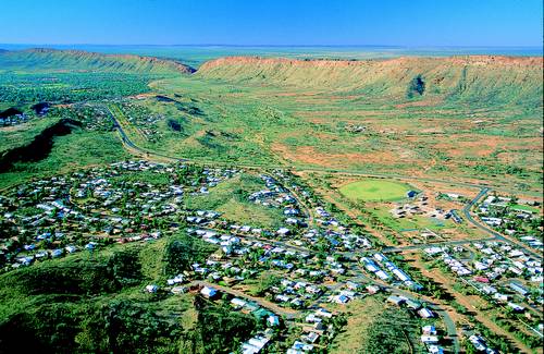
Alice Springs, Northern Territory, Australia
- Latitude/ Longitude
- 23 degrees 42 minutes S/ 133 degrees 52 minutes E [1]
- Elevation
- 580.3392 meters [1]
- Large Body of Water
- Todd River [1]
Contents
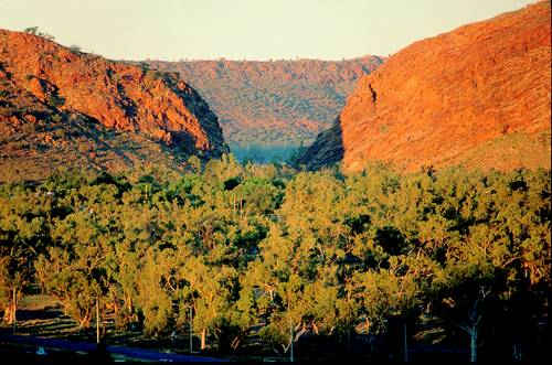
Climate
Climate Zone
BWH (desert or arid) on the Koppen Classification Chart [2]
This city has a similar climate to Lima, Peru Earth Science 7-Lima, Peru
Average Temperature
| Jan. | Feb | Mar. | Apr. | May | June | July | Aug. | Sept. | Oct. | Nov. | Dec. | |
|---|---|---|---|---|---|---|---|---|---|---|---|---|
| Average Temp. (C˚) | 28 | 27 | 25 | 20 | 15 | 12 | 11 | 14 | 18 | 22 | 25 | 27 |
| Average. High (C˚) | 36.4 | 35.0 | 32.7 | 28.2 | 23.0 | 19.8 | 19.7 | 22.6 | 27.2 | 30.9 | 33.6 | 35.4 |
| Average Low (C˚) | 21.4 | 20.8 | 17.5 | 12.6 | 8.3 | 5.1 | 4.0 | 6.0 | 10.3 | 14.8 | 17.8 | 20.2 |
Average Precipitation
| Jan. | Feb. | Mar. | Apr. | May | June | July | Aug. | Sept. | Oct. | Nov. | Dec. | |
|---|---|---|---|---|---|---|---|---|---|---|---|---|
| Average Precipitation (mm) | 38.6 | 43.4 | 31 | 16.6 | 19 | 14 | 15.3 | 9.4 | 8.6 | 21.1 | 28.2 | 37.1 |
| Average Snowfall (mm) | Snow Happens Occasionally in the Winter Season, when it rains, but not enough to gather a conclusive data chart. |
Pressure
Alice Springs is a primarily high pressure area. This means that the weather is mostly hot because of the wind coming from the south.
Factors that Regulate Climate
Alice Springs is on the banks of the Todd River which regulates the temperature all year. It is a desert climate that is raised considerably off sea level. It is considered a pleatueu, a mostly flat area and that increases the temperature.
Cite error: Closing </ref> missing for <ref> tag
Geology
Tectonic Plate Boundary Near Alice Springs
Alice Springs is situated on the Australian Plate about 3093 km (1921 miles) from a plate boundary. [1]
Rocks that Underlie Alice Springs
The rock that sits under Alice Springs is mostly compressed and conglomerated sandstone. Sandstone is resistant to weathering and erosion, and is quite stable. Alice Springs is the closest town to Uluru, a famous sandstone rock formation in central Australia.[3]

References
- ↑ 1.0 1.1 1.2 1.3 Google Earth, 2010, Alice Springs, Australia
- ↑ http://www.uwmc.uwc.edu/geography/100/koppen_web/koppen_map.htm
- ↑ http://en.wikipedia.org/wiki/Uluru