Difference between revisions of "Earth Science 7- Europe and Iceland 5"
m |
|||
| Line 151: | Line 151: | ||
Mesta | Mesta | ||
| + | |||
Pyrenes | Pyrenes | ||
| + | |||
Alps | Alps | ||
| + | |||
Kjolen Mts | Kjolen Mts | ||
| + | |||
Scandinavian Shield | Scandinavian Shield | ||
| + | |||
Central Russia Upland | Central Russia Upland | ||
| + | |||
Ural Mountains | Ural Mountains | ||
| + | |||
Caucasus Mts | Caucasus Mts | ||
| + | |||
Balkan Mts | Balkan Mts | ||
| + | |||
Great Hungarian Plain | Great Hungarian Plain | ||
| + | |||
Dinaric Alps | Dinaric Alps | ||
| + | |||
Massif Central | Massif Central | ||
| + | |||
Carpathian Mts | Carpathian Mts | ||
Iceland= | Iceland= | ||
| + | |||
| + | http://maps.grida.no/library/files/iceland_topographic_map_thumbnail.jpg | ||
Vatnajakull Glacier | Vatnajakull Glacier | ||
| + | |||
Myradalsjokull Glacier | Myradalsjokull Glacier | ||
| + | |||
Longjakull Glacier | Longjakull Glacier | ||
| + | |||
Hosjakull Glacier | Hosjakull Glacier | ||
| + | |||
Drangojokull Glacier | Drangojokull Glacier | ||
Revision as of 19:18, 27 November 2011
Europe and Iceland
Latitude and Longitude Ranges
Europe:Latitude: Approx. 37.5 Degrees N. to 67.5 Degrees N. Longitude: Approx. 15 Degrees W. to 30 Degrees E.
Iceland: Latitude: 67 Degrees N. to 62 Degrees N. Longitude: 14 Degrees W. to 23 Degrees W.
Countries
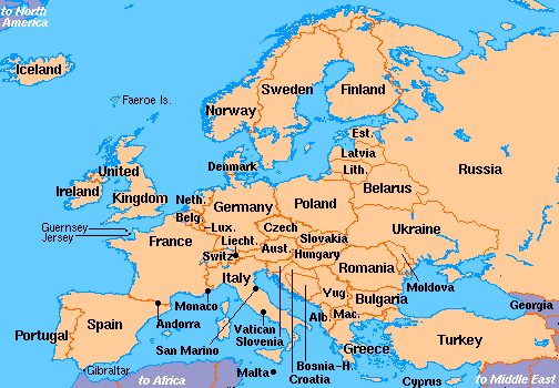
Albania, Andorra, Austria, Azerbaijan (European), Belarus, Belgium, Bosnia-Herzegovina, Bulgaria, Croatia, Czech Republic, Denmark, Estonia, Finland, France, Georgia (European), Germany, Greece, Hungary, Iceland, Ireland, Italy, Kazakhstan (European), Kosovo, Latvia, Liechtenstein, Lithuania, Luxembourg, Macedonia, Malta, Moldova, Monaco, Montenegro, Netherlands, Norway, Poland, Portugal, Romania, Russia, San Marino, Serbia, Slovakia, Slovenia, Spain, Sweden, Switzerland, Turkey (European), Ukraine, United Kingdom, Vatican City
Bordering Oceans
For both=
Atlantic Ocean
North Atlantic
Arctic Ocean
Large bodies of water
North Sea, English Channel, Bay of Biscay, Mediterranean Sea, Sea of Azov, Caspian Sea, Norwegian Sea, Greenland Sea, Denmark Strait, Faza Bay, Barrents Sea, Caspian Sea, Celtic Sea, Irish Sea,
Large Rivers
Europe=
Volga, Don, Dnieper, Tagus, Lorie, Thames, Shannon, Rhine, Oder, Danube, Elbe,
Iceland=
Thjorsa, Jokulsa a Fjollum, Blanda, Lagarfljot, Skjalfandafljot, Hvita,
Elevation Range, highest/lowest points
Iceland=
lowest point: Atlantic Ocean 0 meters highest point: Hvannadalshnukur 2,119 m
Europe=
lowest point: Caspian Sea -28 m highest point: Mt. Elbrus 5,642 m
Climate Zones

Europe=
Cfb(Marine West Coast= warm summer, equally spread rainfall year round
Csa(Mediterranean)= dry, hot summer, frost danger in winter
Iceland=
Dwd(Hunid Continental)= very cold,dry winter, cool summer
Ef(Ice Cap) = Perennial ice
Major topographic features
Europe=
Mesta
Pyrenes
Alps
Kjolen Mts
Scandinavian Shield
Central Russia Upland
Ural Mountains
Caucasus Mts
Balkan Mts
Great Hungarian Plain
Dinaric Alps
Massif Central
Carpathian Mts
Iceland=

Vatnajakull Glacier
Myradalsjokull Glacier
Longjakull Glacier
Hosjakull Glacier
Drangojokull Glacier
Average monthly temperatures
Iceland=
high: 45.83 Degrees Fahrenheit low: 37. 08 Degrees Farhrenheit

Europe=
high: low:
Average monthly rainfall
Iceland:
Europe:
Average monthly precipitation
Iceland: 66.52 mm
Europe:
Factors that affect the Climate
Iceland has a dry and cold winter season and a cool summer. The majority of the major topographic features are glaciers. The southern and western regions of Iceland experience mild winter temperatures because of the warm waters of the Gulf Stream. The location and latitude of Iceland affect its climate. Iceland is located in the Northern Hemisphere and is near the Arctic Circle and North Pole. These are some of the reasons why Iceland is cold. The weather in Iceland is mostly influenced by the atmospheric depressions crossing the North Atlantic. These are called "Iceland-lows". The rainfall on the south coast of Iceland is quite high, while in the northern highlands the rainfall is quite low. Winter snowfall occurs mostly in the northern areas of Iceland. Thunderstorms are rare in Iceland.
Prevailing winds blow from the Atlantic Ocean to Europe. Europe is typically wet year round and has a dry summer season. Europe is in the Northern Hemisphere and so its location and latitude affect its climate. Europe's variation in vegetation probably is one of the reasons why Europe has a such wide range in climate. Its vegetation varies from ice caps to forest to grasslands. Part of Europe is next to a body of water and this masses of water probably affect the climate of Europe.
http://www.worldbookonline.com/advanced/article?id=ar186660&st=europe
http://www.worldatlas.com/webimage/countrys/eu.htm
http://www.worldatlas.com/webimage/countrys/euriv.htm
http://www.worldatlas.com/aatlas/infopage/highlow.htm
http://www.worldatlas.com/webimage/countrys/europe/is.htm
http://maps.google.com/maps?gcx=w&q=europe&um=1&ie=UTF-8&hl=en&sa=N&tab=wl
http://www.srh.noaa.gov/jetstream/global/climate_max.htm
http://www.infoplease.com/ipa/A0001763.html
http://www.worldatlas.com/webimage/countrys/euland.htm
http://www.worldatlas.com/webimage/countrys/europe/iceland/isfacts.htm
http://www.weatheronline.co.uk/reports/climate/Iceland.htm
http://goscandinavia.about.com/od/icelan1/ss/weathericeland.htm