Difference between revisions of "Earth Science 7-South America3"
m (→Angel Falls) |
|||
| Line 89: | Line 89: | ||
==Angel Falls== | ==Angel Falls== | ||
| − | + | The rocks and cliffs forming the tepuis were ancient long before the continent of South America separated from Africa. Now they are home to dense rain forests, clouds of mist and huge sandstone formations. From the top of one tepui, an unbroken stream of water takes fourteen seconds to fall to the base. | |
==Galapagos Islands== | ==Galapagos Islands== | ||
Revision as of 10:06, 18 April 2012
Contents
South American Countries
Argentina, Brazil, Paraguay, Bolivia, Peru, Colombia, Chile, Guyane, Suriname, Guyana, Paraguay, Uruguay, Falkland Islands, and Ecuador.
Latitude and Longitude Range
7°53'02.45"N-54°48'27.31"S, 64°07'15.01"W-77°48'40.80"W
South American Geographic Features
Amazon Basin, Andes Mountain, Atacama Desert, Brazilian Highlands, Brazilian Shield, Cape Horn, Guina Highlands, Llanos, Pampas, Pantanal, Patagonia, Tierra del Fuego
Bodies of Water
General Bodies of Water
Bordering Oceans
Rivers
Lakes
Gulfs
Currents
Elevation Range
Highest: Aconcagua, Argentina: 22,834 feet / 6960 meters Lowest: Laguna del Carbon (located between Puerto San Julian and Comandante Luis Piedra Buena in the province of Santa Cruz): 344 feet / 105 meters below sea level
Main Topographic Figures

Andes Mountains
The Andes are a young mountain system, ranging 4500 miles from the northern coasts to the tip of Tierra del Fuego. Live volcanos dot the stretch, and form part of the Pacific Rim of Fire. In Peru and Bolivia, the Andes widen into several ranges separated by valleys supporting farms and cities. The greatest peak is Aconcagua on the border of Argentina and Chile.

Atacama Desert
Known erroneously as the driest desert on earth, this narrow strip of coastal desert stretches east to the Andes, and is a mix of lava flows, salt basins, hot springs and sand covering about 600 miles south from Chile's border with Peru. The barren and unforgiving terrain serves as practice grounds for space exploration.
Tierra del Fuego
28,470 square miles in size, separated from the southern tip of the South American mainland by the Strait of Magellan, Tierra del Fuego is cold, windy and wildly scenic.
Patagonia
Patagonia in Argentina and Chile is home to great glaciers, volcanos, glacier fed lakes, and fast rushing rivers. Majestic volcanos like Osorno in Chile, Perito Moreno Glacier in Argentina and the fantastic fjords of Chile are all reminders of the wonders of nature.
Lake Titicaca
This high altitude lake, over 12,000 feet high and about 900 feet deep, this is the second largest lake in South America. With an area about 3200 square feet, 122 miles long with an average width of 35 miles, with 36 islands, the lake is reputed to be the highest navigable lake in the world.
Amazon River
Carving a huge channel through a rainforest which is home to more wildlife species than anywhere else on earth, the Amazon river runs over 4000 miles from its origins to the Atlantic where in one second, it pours more than 55 million gallons of water into the sea. The Amazon basin covers more than two-fifths of South America's land mass.
Angel Falls
The rocks and cliffs forming the tepuis were ancient long before the continent of South America separated from Africa. Now they are home to dense rain forests, clouds of mist and huge sandstone formations. From the top of one tepui, an unbroken stream of water takes fourteen seconds to fall to the base.
Galapagos Islands
Called the world's greatest living laboratory, these barren islands in the middle of two cold currents support a fantastic array of wildlife that has developed into new forms such as the marine iguana and the flightless cormorant, huge sea turtles, plus sea lions and penguins far from their original habitats.
Climate
Climates include an Equitorial fully humid zone near the top of South America, an equitorial monsoonal area surrounding the humid zone, an equitorial winter dry both above and below the monsoonal area, a warm humid area with hot summers under the winter dry and slightly to the east, 2 cold arid steppes in the winter dry, a warm desert hot summer to the west of the humid hot summer area, a polar tundra spanning near most of the west coast, another cold arid steppe under the warm humid hot summer area, warm dry summer to the right of the lower cold arid steppe, a warm fully humid with a warm summernnear the southern tip, and an equitorial summer dry off on an island off the northeastern coast. The coastline and topography change these climates. Because it has a middle latitude it is mostly warm. Mainly, because South America is at the ITCZ it has a lot of moisture, and has a lot of tropics. The polar tundra is when the ITCZ moves either up or down. When it is dry that is another effect of the moving ITCZ.
Minerals
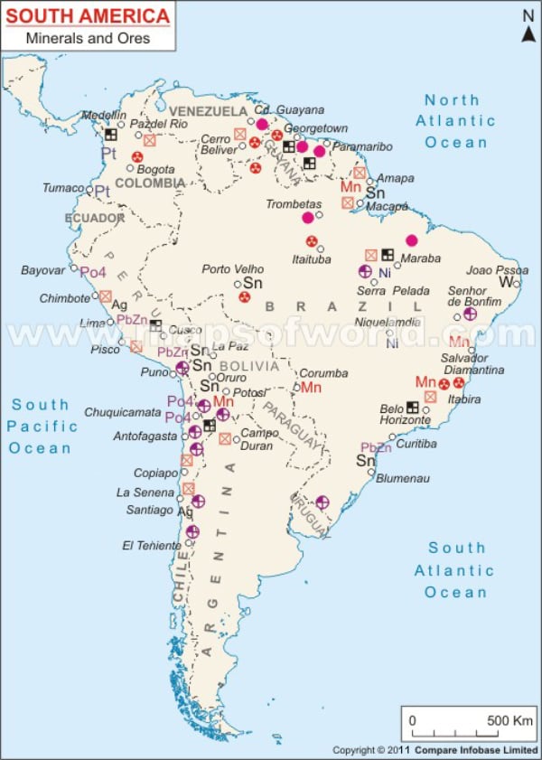 There are many fascinating minerals in South America. Brazil, being the largest country in South America, obviously contains the most minerals. However, there are many interesting minerals in the other countries. Peru has the minerals silver, and fluorite. Chile has Proustite, and Colombia has Emerald. Brazil has the beautiful minerals Chrysoberyl, Uranocircite, Brazilianite, Herderite, Hematite, Tourmaline, and Quartz with Kaolinite. South America's most abundant rock is aluminum, while other leading rocks are gold, lead, and quartz, all boosting South America's economy.
Plate Tectonics
Plate Boundaries
South America is composed of 4 plates. The plates are the South America plate, th eAltiplano plate, the Scotia plate, and the North Andes plate. There is a convergent boundary with the Sandwich and Scotia plates, and there is a convergent boundary between the North Andes plate and the South America plate. The South America plate and the Scotia plate. There is a convergent boundary i nbetween the Nazca plate and the Altiplano plate. This is an active margin. There is a convergent boundary between the Altiplano plate and the South America plate. There is a divegent boundary between the African plate and the South American plate. That is a passive margin.
Volcanoes
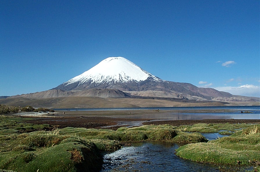
South America has many volcanoes, and they tend to appear on the western coast, because of the active margin. The volcano below, Volcan Parinacota, is a young symmetrical composite volcano in northern Chile near the border with Bolivia. It forms with the Pomerape volcano to make the Nevados de Payachata volcanic group. Parinacota contains a pristine 300 meter wide summit crater. This is a prime example of how most volcanoes in South America form on the West Coast.
Earthquakes
Earthquakes also tend to be on the western coast because of the active margin. They trend deeper the farther inland you get from the west coast. They also appear along the boundary of the Scotia plate.
Links
Global Regions Index
Earth Science 7-Global Regions Index
Unused
http://gosouthamerica.about.com/library/blSamaps3a.htm https://www.cia.gov/library/publications/the-world-factbook
Reference
http://www.worldatlas.com (Major Bodies of Water) http://www.britannica.com/EBchecked/topic/443550/Gulf-of-Paria (Major Bodies of Water) http://www.about.com (Elevation Range) koppen-geiger.vu-wein.ac.at/present.htm (Climate) Google Earth (Latitude/Longitude range, Countries/Regions, Plate Tectonics) Dynamic_Earth.kmz (Plate Tectonics) http://www.mapsofworld.com/south-america/minerels-and-ores.html (South America mineral map)
http://www.fotopaises.com/foto/Chile/Volcan_Parinacota/Original/37153.html (Volcan Parinacota)