Difference between revisions of "Earth Science 7- Europe and Iceland 5"
(→''Sources'') |
(→'''Earthquakes''') |
||
| Line 309: | Line 309: | ||
The European region does have earthquakes, mainly being caused by the movements along the Eurasian, Arabian, North American, and African plates. While looking at the earthquakes that occur in Europe, I noticed that almost all noticeable ones tend to occur in Italy. For example, the earthquake that hit Messina, Italy in December 28, 1908 with a magnitude of 7.2. The earthquake of Messina had over 70,000 deaths. Another example of an Italian earthquake is the earthquake that occurred in Sicily on January 11, 1693. Since the earthquake occurred in 1693 the magnitude is unavailable, but there were 60,000 deaths. Another Italian earthquake was on February 4, 1783 in Calabria, Italy. The magnitude of this earthquake is also unavailable, but there were 50,000 deaths. While looking at a volcanic map, I saw that there were quite a few volcanoes near or on Italy and since earthquakes can result in the eruption of an volcano, it is very likely that these earthquakes were formed from the aftermath of a volcanic eruption. A more recent, but still Italian earthquake was on April 6, 2009 in Central Valley with a magnitude of 6.3. Another example of another recent and European earthquake, is on that occurred on October 23, 2011 in Eastern Turkey with a magnitude of 7.1. An earthquake that struck on October 20, 1930, in Italy had a magnitude of 6.6. | The European region does have earthquakes, mainly being caused by the movements along the Eurasian, Arabian, North American, and African plates. While looking at the earthquakes that occur in Europe, I noticed that almost all noticeable ones tend to occur in Italy. For example, the earthquake that hit Messina, Italy in December 28, 1908 with a magnitude of 7.2. The earthquake of Messina had over 70,000 deaths. Another example of an Italian earthquake is the earthquake that occurred in Sicily on January 11, 1693. Since the earthquake occurred in 1693 the magnitude is unavailable, but there were 60,000 deaths. Another Italian earthquake was on February 4, 1783 in Calabria, Italy. The magnitude of this earthquake is also unavailable, but there were 50,000 deaths. While looking at a volcanic map, I saw that there were quite a few volcanoes near or on Italy and since earthquakes can result in the eruption of an volcano, it is very likely that these earthquakes were formed from the aftermath of a volcanic eruption. A more recent, but still Italian earthquake was on April 6, 2009 in Central Valley with a magnitude of 6.3. Another example of another recent and European earthquake, is on that occurred on October 23, 2011 in Eastern Turkey with a magnitude of 7.1. An earthquake that struck on October 20, 1930, in Italy had a magnitude of 6.6. | ||
| − | + | http://www.volcano.si.edu/world/region.cfm?rnum=01 | |
| − | + | <ref>[http://www.volcano.si.edu/world/region.cfm?rnum=01].</ref> | |
The Icelandic region does have earthquakes, which are mainly caused by the movements along the Eurasian and North American plate. While looking at a map of the earthquakes that occur in Iceland, the majority of the earthquakes occur along southwest border and a few occur closer to the eastern and northern border. A more recent earthquake that occurred in southwestern Iceland struck on May 29, 2008 with a magnitude of 6.3. Another earthquake hit southern Iceland on June 17 and 21, 2000 with a magnitude of 6.5-6.6. A more recent earthquake was actually today, April the 21, 2012, with a magnitude of 1.4. This earthquake was southeast of Grimsey. Another recent earthquake hit on April 20,2012, with a magnitude of 3.0, this earthquake was southeast of Basar. An earthquake that struck on April 19, 2012, had a magnitude of 1.1 and occurred southwest of Hestfjall. While searching earthquakes that have occurred in Iceland, there was a drastic difference between the amount that Iceland had the amount Europe had. An earthquake that occurred on May 6, 1912, had a magnitude of 7.0. | The Icelandic region does have earthquakes, which are mainly caused by the movements along the Eurasian and North American plate. While looking at a map of the earthquakes that occur in Iceland, the majority of the earthquakes occur along southwest border and a few occur closer to the eastern and northern border. A more recent earthquake that occurred in southwestern Iceland struck on May 29, 2008 with a magnitude of 6.3. Another earthquake hit southern Iceland on June 17 and 21, 2000 with a magnitude of 6.5-6.6. A more recent earthquake was actually today, April the 21, 2012, with a magnitude of 1.4. This earthquake was southeast of Grimsey. Another recent earthquake hit on April 20,2012, with a magnitude of 3.0, this earthquake was southeast of Basar. An earthquake that struck on April 19, 2012, had a magnitude of 1.1 and occurred southwest of Hestfjall. While searching earthquakes that have occurred in Iceland, there was a drastic difference between the amount that Iceland had the amount Europe had. An earthquake that occurred on May 6, 1912, had a magnitude of 7.0. | ||
Revision as of 09:56, 21 April 2012
Contents
- 1 Europe and Iceland
- 1.1 Latitude and Longitude Ranges
- 1.2 Countries
- 1.3 Bordering Oceans
- 1.4 Large bodies of water
- 1.5 Large Rivers
- 1.6 Elevation Range, highest/lowest points
- 1.7 Climate Zones
- 1.8 Major topographic features
- 1.9 Average monthly temperatures
- 1.10 Average monthly rainfall
- 1.11 Average monthly precipitation
- 1.12 Factors that affect the Climate
- 1.13 Geology
- 1.14 Tectonic Plates
- 1.15 Links
- 1.16 Sources
- 1.17 ↑ [1]. ↑ [2]. ↑ [3]. ↑ [4]. ↑ [5]. ↑ [6]. ↑ [7]. ↑ [8].
Europe and Iceland
Latitude and Longitude Ranges
Europe:Latitude: Approx. 37.5 Degrees N. to 67.5 Degrees N. Longitude: Approx. 15 Degrees W. to 30 Degrees E.
Iceland: Latitude: 67 Degrees N. to 62 Degrees N. Longitude: 14 Degrees W. to 23 Degrees W.
Countries
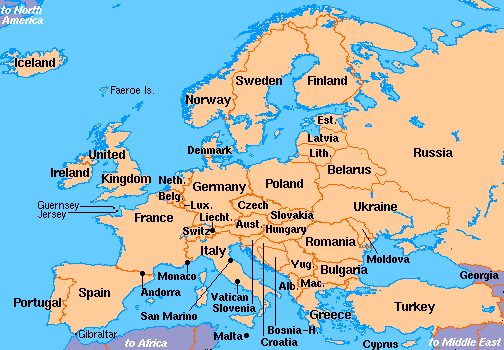
Albania, Andorra, Austria, Azerbaijan (European), Belarus, Belgium, Bosnia-Herzegovina, Bulgaria, Croatia, Czech Republic, Denmark, Estonia, Finland, France, Georgia (European), Germany, Greece, Hungary, Iceland, Ireland, Italy, Kazakhstan (European), Kosovo, Latvia, Liechtenstein, Lithuania, Luxembourg, Macedonia, Malta, Moldova, Monaco, Montenegro, Netherlands, Norway, Poland, Portugal, Romania, Russia, San Marino, Serbia, Slovakia, Slovenia, Spain, Sweden, Switzerland, Turkey (European), Ukraine, United Kingdom, Vatican City
Bordering Oceans
For both=
Atlantic Ocean
North Atlantic
Arctic Ocean
Large bodies of water
North Sea, English Channel, Bay of Biscay, Mediterranean Sea, Sea of Azov, Caspian Sea, Norwegian Sea, Greenland Sea, Denmark Strait, Faza Bay, Barrents Sea, Caspian Sea, Celtic Sea, Irish Sea,
Large Rivers
Europe=
Volga, Don, Dnieper, Tagus, Lorie, Thames, Shannon, Rhine, Oder, Danube, Elbe,
Iceland=
Thjorsa, Jokulsa a Fjollum, Blanda, Lagarfljot, Skjalfandafljot, Hvita,
Elevation Range, highest/lowest points
Iceland:
lowest point: Atlantic Ocean 0 meters highest point: Hvannadalshnukur 2,119 m
Europe:
lowest point: Caspian Sea -28 m highest point: Mt. Elbrus 5,642 m
Climate Zones
Europe:
Cfb(Marine West Coast= warm summer, equally spread rainfall year round
Csa(Mediterranean)= dry, hot summer, frost danger in winter
Iceland:
Dwd(Hunid Continental)= very cold,dry winter, cool summer
Ef(Ice Cap) = Perennial ice

Major topographic features
Europe=
Mesta
Pyrenes
Alps
Kjolen Mts
Scandinavian Shield
Central Russia Upland
Ural Mountains
Caucasus Mts
Balkan Mts
Great Hungarian Plain
Dinaric Alps
Massif Central
Carpathian Mts
Iceland=
Vatnajakull Glacier
Myradalsjokull Glacier
Longjakull Glacier
Hosjakull Glacier
Drangojokull Glacier

Average monthly temperatures
Iceland=
high: 45.83 Degrees Fahrenheit low: 37. 08 Degrees Farhrenheit

Europe=
Cfb region: Paris, France
high: 58.5 Degrees Fahrenheit low: 47.41 Degrees Fahrenheit
Csa region: Athens, Greece
low: 71.75 Degrees Fahrenheit high: 56.58 Degrees Fahrenheit
Average monthly rainfall
Iceland=
Dwd region: Reykjavik: 68 mm
Ef region: Myvatn: 4.5 mm
Europe=
Csa region: Athens, Greece: 1.25 inches
Cfb region: Paris, France: 51.83 mm
Average monthly precipitation
Iceland: 66.52 mm
Europe:
Csa region: Athens, Greece: 1.25 inches
Cfb region: Paris, France: 55.08 mm
Factors that affect the Climate
Iceland has a dry and cold winter season and a cool summer. The majority of the major topographic features are glaciers. The southern and western regions of Iceland experience mild winter temperatures because of the warm waters of the Gulf Stream. The location and latitude of Iceland affect its climate. Iceland is located in the Northern Hemisphere and is near the Arctic Circle and North Pole. These are some of the reasons why Iceland is cold. The weather in Iceland is mostly influenced by the atmospheric depressions crossing the North Atlantic. These are called "Iceland-lows". The rainfall on the south coast of Iceland is quite high, while in the northern highlands the rainfall is quite low. Winter snowfall occurs mostly in the northern areas of Iceland.Iceland is low a pressure area, which may be the reason why thunderstorms are rare in Iceland.
Prevailing winds blow from the Atlantic Ocean to Europe. Europe is typically wet year round and has a dry summer season. Europe is in the Northern Hemisphere and so its location and latitude affect its climate. Europe's variation in vegetation probably is one of the reasons why Europe has a such wide range in climate. Its vegetation varies from ice caps to forest to grasslands. Part of Europe is next to a body of water and this masses of water probably affect the climate of Europe.Europe is both a high and low pressure area. The combination of both high and low pressures is probably the reason why throughout Europe the climate is typically the same. The climate of Europe is strongly affected by the Gulf Stream, because warms it warms the western region of Europe. The tornadoes in Europe also affect its climate.
Geology
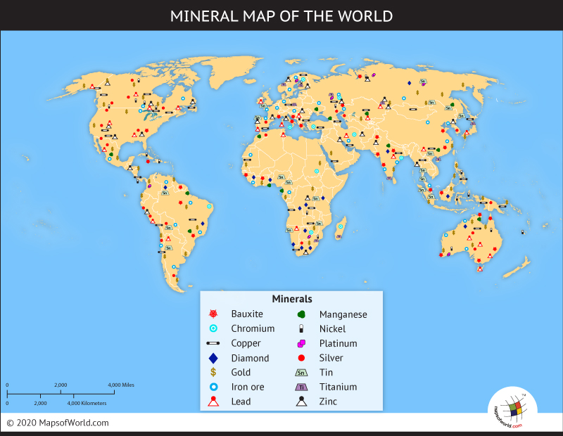
Mining Resources
Europe: Uranium, Coal, Tin, Lead, Zinc, Titanium, Iron, Platinum, Oil, Copper, Bauxite, and Silver
Iceland: Oil, Tin, Coal, Lead and Diatomite

Minerals
These are some of the examples of the minerals found in Europe and Iceland.
Europe:
Italy: Analcime, Anhydrite, Andalusite, Mica, Dolomite, Magnesite, Sulfur, Chalcocite, Olivine, Augite, Pyrite, Limonite, Titanite Sicily: Analcime Spain: Anhydrite, Andalusite, Cinnabar, Pyrite Scotland: Mica Germany: Mica, Limonite, Calcite, Galena, Bismuth, Bornite, Ettringite, Cerussite, Mimetite, Titanite, Smithsonite, Cubanite Austria: Mica, Galena, Epidote, Titanite Finland: Mica Switzerland: Mica, Dolomite, Magnesite, Quartz, Beryl, Prehnite, Danburite, Titanite England: Fluorite, Calcite, Ankerite, Bornite, Hilgardite, Mimetite Luxembourg: Limonite France: Limonite, Calcite, Epidote, Chalcotrichite, Wardite Ireland: Calcite, Ettringite Sweden: Bismuth, Hausmannite, Molybdenite Hungary: Ankerite, Enargite Poland: Bornite Ireland: Calcite, Beryl, Ettringite, Natrolite Scotland: Prehnite, Staurolite Netherlands: Ferberite Norway: Epidote, Datolite Turkey: Orpiment
Iceland: Opal, Mesolite, Stilbite, Calcite, Aragonite
Rock Types
Europe: By looking at a physical feature map of Europe, you can tell that Europe mainly has metamorphic and sedimentary rocks. Metamorphic rocks can form from the weight of overlying rock and the deformation of rock as mountains build. So, metamorphic rocks typically form near mountains. There are many major mountain ranges in Europe, such as the Alps and the Carpathian Mountains, so you know that there are probably metamorphic rocks in Europe. Sedimentary rocks form from the compaction and cementation of existing rocks. The formation of sedimentary rocks form in plains and near river valleys. In Europe, there is the Plain of France and Northern European Plain, which shows that there are sedimentary rocks in Europe. A major river valley in Europe is the Rhine River Valley, where probably a lot of sedimentary rocks form.
Iceland: Just by knowing the physical features of Iceland, you know that the main type of rocks there are extrusive igneous rocks, because of the large amount of volcanoes that are on the island. There are also a lot of hot springs on Iceland, which result from the emergence of groundwater that has passed through or near recently formed, hot, igneous rocks. The extrusive igneous rocks on Iceland are are formed when hot magma from volcanoes cools and becomes solid. You also know that Iceland has metamorphic rocks because Iceland has glaciers where rocks can form from the weight of overlying rock. A major glacier in Iceland is the Vatnajokull glacier.
Tectonic Plates
Relevant Plates
The plates in the Icelandic-European area are the Eurasian Plate, the African Plate, and the North American Plate. The boundary types for the boundaries are: North American/Eurasian: Eurasian/African: African/North American:
Volcanoes
The European/Icelandic region does have volcanoes, the ones in Iceland being due to the mid-oceanic ridge in the Atlantic Ocean. The Icelandic volcanoes do have significance, as they heat springs, and a few years ago they erupted, causing mayhem throughout the world, as flights were cancelled, and people were stuck hundreds of miles from home. This also caused the transportation of goods through a huge area surrounding the volcano to have to reroute or not be transported. Another thing that happened is that animals and people, as well as things from the Plant Kingdom, probably died. About 79% of Iceland's area is of recent volcanic origin.
Earthquakes
The European region does have earthquakes, mainly being caused by the movements along the Eurasian, Arabian, North American, and African plates. While looking at the earthquakes that occur in Europe, I noticed that almost all noticeable ones tend to occur in Italy. For example, the earthquake that hit Messina, Italy in December 28, 1908 with a magnitude of 7.2. The earthquake of Messina had over 70,000 deaths. Another example of an Italian earthquake is the earthquake that occurred in Sicily on January 11, 1693. Since the earthquake occurred in 1693 the magnitude is unavailable, but there were 60,000 deaths. Another Italian earthquake was on February 4, 1783 in Calabria, Italy. The magnitude of this earthquake is also unavailable, but there were 50,000 deaths. While looking at a volcanic map, I saw that there were quite a few volcanoes near or on Italy and since earthquakes can result in the eruption of an volcano, it is very likely that these earthquakes were formed from the aftermath of a volcanic eruption. A more recent, but still Italian earthquake was on April 6, 2009 in Central Valley with a magnitude of 6.3. Another example of another recent and European earthquake, is on that occurred on October 23, 2011 in Eastern Turkey with a magnitude of 7.1. An earthquake that struck on October 20, 1930, in Italy had a magnitude of 6.6.
http://www.volcano.si.edu/world/region.cfm?rnum=01 [7]
The Icelandic region does have earthquakes, which are mainly caused by the movements along the Eurasian and North American plate. While looking at a map of the earthquakes that occur in Iceland, the majority of the earthquakes occur along southwest border and a few occur closer to the eastern and northern border. A more recent earthquake that occurred in southwestern Iceland struck on May 29, 2008 with a magnitude of 6.3. Another earthquake hit southern Iceland on June 17 and 21, 2000 with a magnitude of 6.5-6.6. A more recent earthquake was actually today, April the 21, 2012, with a magnitude of 1.4. This earthquake was southeast of Grimsey. Another recent earthquake hit on April 20,2012, with a magnitude of 3.0, this earthquake was southeast of Basar. An earthquake that struck on April 19, 2012, had a magnitude of 1.1 and occurred southwest of Hestfjall. While searching earthquakes that have occurred in Iceland, there was a drastic difference between the amount that Iceland had the amount Europe had. An earthquake that occurred on May 6, 1912, had a magnitude of 7.0.
http://www.nowpublic.com/world/more-earthquakes-iceland-today-0
[8]
Links
[[9]]
[[10]]
Sources
http://www.worldbookonline.com/advanced/article?id=ar186660&st=europe
http://www.worldatlas.com/webimage/countrys/eu.htm
http://www.worldatlas.com/webimage/countrys/euriv.htm
http://www.worldatlas.com/aatlas/infopage/highlow.htm
http://www.worldatlas.com/webimage/countrys/europe/is.htm
http://maps.google.com/maps?gcx=w&q=europe&um=1&ie=UTF-8&hl=en&sa=N&tab=wl
http://www.srh.noaa.gov/jetstream/global/climate_max.htm
http://www.infoplease.com/ipa/A0001763.html
http://www.worldatlas.com/webimage/countrys/euland.htm
http://www.worldatlas.com/webimage/countrys/europe/iceland/isfacts.htm
http://www.weatheronline.co.uk/reports/climate/Iceland.htm
http://goscandinavia.about.com/od/icelan1/ss/weathericeland.htm
https://notendur.hi.is/oi/climate_in_iceland.htm
http://maps.howstuffworks.com/europe-vegetation-map.htm
http://www.weather.com/outlook/travel/vacationplanner/wxclimatology/monthly/graph/FRXX0076
http://www.weather.com/outlook/travel/vacationplanner/wxclimatology/monthly/graph/GRXX0004
http://www.weather-and-climate.com/average-monthly-Rainfall-Temperature-Sunshine,Paris,France
http://france-for-visitors.com/paris/guide/temperatures-and-rainfall.html
http://www.worldweatheronline.com/weather-averages.aspx?q=MVA
http://www.climatetemp.info/iceland/reykjavik.htmlw
http://www.woeurope.eu/reports/wxfacts/Isobars-on-surface-maps.htm
https://www.cia.gov/library/publications/the-world-factbook/geos/ic.html
http://www.infoplease.com/ce6/sci/A0824279.html
http://en.wikipedia.org/wiki/List_of_deadly_earthquakes_since_1900 http://www.infoplease.com/dk/science/encyclopedia/rocks.html
http://www.infoplease.com/country/profiles/iceland.html
http://www.infoplease.com/ipa/A0884804.html
http://www.infoplease.com/world/disasters/earthquake-deaths-2009.html
http://www.infoplease.com/world/disasters/earthquake-deaths-2011.html
http://hraun.vedur.is/ja/englishweb/eqlist.html
↑ [1].
↑ [2].
↑ [3].
↑ [4].
↑ [5].
↑ [6].
↑ [7].
↑ [8].
![[5]](http://en.wikipedia.org/wiki/File:Simplified_world_mining_map_2.png)
![[8]](http://media.nowpublic.net/images//89/7/8973cf873dccb12b2afcd57ba8be7db4.jpg)
↑ [2].
↑ [3].
↑ [4].
↑ [5].
↑ [6].
↑ [7].
↑ [8].