Difference between revisions of "Earth Science 7- Northern Asia 2"
| Line 188: | Line 188: | ||
Boundaries in Northern Asia include the continental-continental boundary of the Indian and Eurasian plates which creates the Himalayas, the oceanic-continenal boundary of the Pacific plate and the Eurasian plate which causes the Japan Trench, and the continental-continental or oceanic-oceanic depending on location boundary between the Eurasian and Pacific plates | Boundaries in Northern Asia include the continental-continental boundary of the Indian and Eurasian plates which creates the Himalayas, the oceanic-continenal boundary of the Pacific plate and the Eurasian plate which causes the Japan Trench, and the continental-continental or oceanic-oceanic depending on location boundary between the Eurasian and Pacific plates | ||
| + | |||
| + | -- Volcanoes | ||
== References == | == References == | ||
Revision as of 09:06, 17 April 2012
Earth Science 7-Global Regions Index
Contents
Northern Asia
 ,
[1]
,
[1]
Countries
Japan
China
Mongolia
Korea
Russia
Afghanistan
Uzbekistan
Turkmenistan
Tajikistan
Kyrgyzstan
Kazakhstan
Taiwan. 1
Latitude and Longitude
Latitude: 18-81 degrees North. 1
Longitude: 28 degrees East, 169 degrees West. 1
Wave Action
Tsunami waves are much longer than common ocean waves. In the open ocean, the water may take from 5 minutes to over 1 hour to reach its highest level and fall back again as a tsunami wave passes. The deeper the water is, the faster a tsunami wave travels. In the Pacific Ocean basin, where depths average about 13,000 feet , tsunami waves can travel up to 600 miles per hour, as fast as a jet aircraft. As a tsunami wave approaches land, its speed drops to about 20 to 30 miles per hour. As the wave’s speed decreases, its height usually grows by at least three times. The resulting flood of water can surge more than 2/3 mile inland and pile up in certain places to reach elevations higher than 100 feet above sea level. 9
Ice Cover
During the last ice age much of the northern hemisphere was covered in ice and glaciers, and they covered nearly all of Canada, much of northern Asia and Europe, and extended well into the United States. But now there's only a few ice covered areas. 10
 </ref>
The world during the last ice age.
Elevation Range
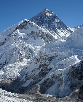
The highest point is Mount Everest with 8,850 m. 1
The lowest point is The Caspian Sea with -132 m. 1
Bordering Oceans
Pacific Ocean
Arctic Ocean. 1
Tides
Mixed tides, where successive high-water and low-water stands, are placed on the southern part of Northern Asia. Diurnal tides, tides have one high and one low water per tidal day, are found in the middle coast. The most common tide is the Semi-diurnal tides, which have two high and two low waters per tidal day. 7 Large tides occur along the Pacific rim. Some of the largest form off the west coast of Korea. There, the water is 15 to 30 feet (4.6 to 9.0 meters) deeper at high tide than at low tide. 8
Large Bodies of Water
Lake Decalog
Korea Bay
Lake Baikal. 2
Currents
The Alaska Current brings warmer water to Russia.
The Kamchatka Current brings cold water to eastern Russia.
Oyashio Current is a cold current that leads to Japan
North Pacific Current brings warm water to Japan and China. 7
The surface currents in most of the Pacific Ocean are parts of two gigantic, rotating systems of current known as gyres. One gyre is centered at about 30° north latitude and rotates clockwise. 8
Major Seas
Sea of Japan
East China Sea
South China Sea
Yellow Sea. 1
Sea of Japan

Topographic Features
Ural Mountains
Himalayas Mountains
Tibetan Plateau
Gobi Desert
Taklamakan Desert
Subarctic Climate in Siberia
Tundra in Siberia
Altai Mountains
Steppes in Kazakhstan and Mongolia
Hentiyn Mountains. 3
Rivers
Yangtze
Yenisei
Lena
Ob
Amur
The Pearl
Ural River
The Yellow
Lao He. 2
Climate
Much of Northern Asia is part of the climate zone humid continental. 4 Climate types include humid, severe and dry winters, and hot summers. 4 In Northern Asia the main climate tends to include snow, arid, polar, and warm temperatures. 5 Precipitation in Northern Asia falls into the categories of fully humid, desert, and a dry winter. 5 Temperature in Northern Asia varies greatly by which part of the region you are in. 5 The climate is a result of the many climate controls. The climate controls are the several mountain ranges, deserts, tundra, and of course the bordering oceans. More climate controls are the elevation and the latitude.
Deserts occur in Mongolia because of the Mongolian Plateau. Many Plateaus contain deserts.6 Because of the southern winds hitting the Himalayan Mountain range, it creates a much warmer temperature in China. 6 There are several small mountain ranges in Russia which provides for it's snowy weather. 6 Also these small mountains stop warm air currents from the south to create deserts on one side, and blizzards on the other. 6 The winds in Russia flow from the north which then trail down into Siberia, causing a colder climate. 6
Minerals Resources
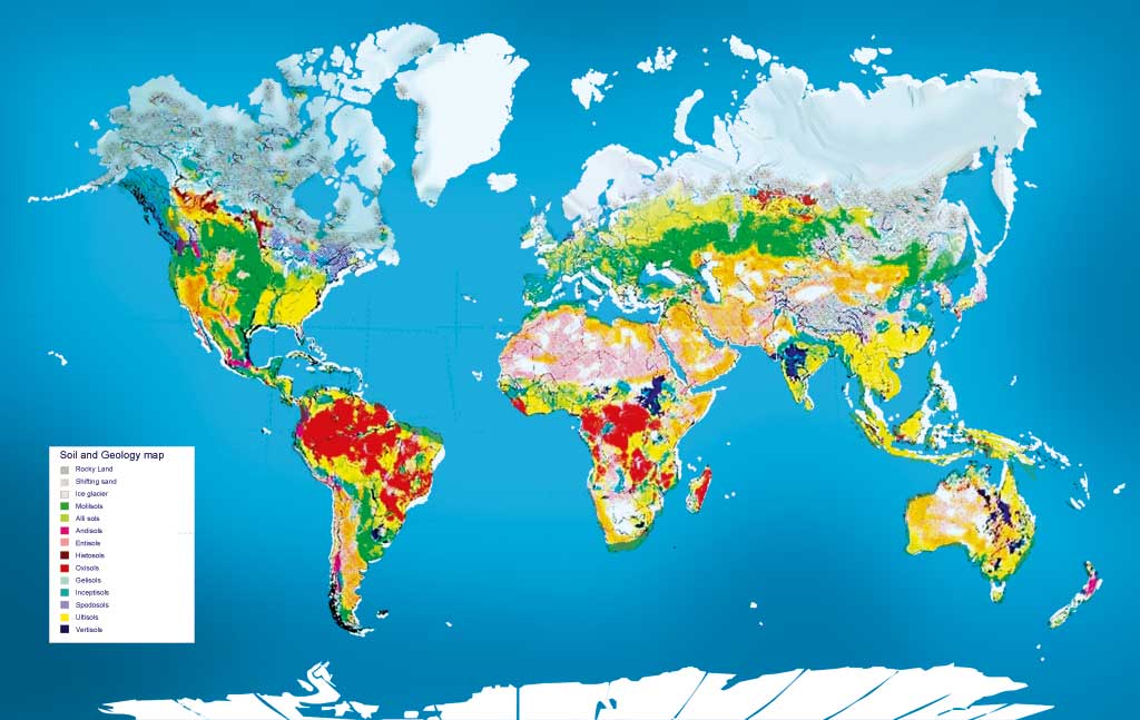
In the earth of Northern Asia you can find metallic minerals such as Titanium, Copper, Tin, Gold, lead, Zinc, Uranium, Platinum, Iron. 11 Other resources in the region include coal, oil, and diamonds. 12 More resources contain natural gases. 13 In Uzbekistan many minerals mined there are coal, gold, uranium, silver, petroleum copper, lead, zinc, tungsten, and molybdenum.13 In Russia there is a volcano called Aaag. This volcano is made of a heavy layer of rock, magma and igneous rock. 14 The Dharwar belt is made up of an assemblage of gneisses, mitigates, and granites containing linear green stone belts in which volcanoes and sedimentary rocks, metamorphosed to a greater or lesser degree, are preserved. Some of the sediments contain rich hematite ores and manganese ores. Gold also occurs associated with basic volcanic rocks or intrusions in the green stone belts. The whole of the Dharwar belt is intruded by swarms of basic dykes, intruded towards the end of the main metamorphic episode, 2,600–2,300 million years ago. In the Aravalli region, banded gneisses of the same general age occur underlying later cover rocks. 16 Kazakhstan is the world’s 11th largest copper producer and has seen some dramatic production increases. 17 Russia has about 10% of global copper reserves. More than 50% of the deposits are being exploited or developed and are hosted primarily by sulphide ores. Mines under development have an average grade of over 1.5% copper. Russia is ranked 6th in the world in terms of copper production, with 55% of Russia’s production coming from Norilsk Nickel. 17 In 2000 Russia remained the world’s 3rd largest producer of diamonds, after Australia and Botswana. Russia accounts for 21% of global diamonds produced. 18
 15
15
Tectonic Plates
Boundaries in Northern Asia include the continental-continental boundary of the Indian and Eurasian plates which creates the Himalayas, the oceanic-continenal boundary of the Pacific plate and the Eurasian plate which causes the Japan Trench, and the continental-continental or oceanic-oceanic depending on location boundary between the Eurasian and Pacific plates
-- Volcanoes
References
http://www.cia.gov/library/publications/the-world-factbook/ 1 http://www.tulane.edu/~riomar/images/Chapter%201.pdf 2 http://depts.washington.edu/silkroad/maps/physical/etopo.html 3 http://www.srh.noaa.gov/jetstream/global/climate_max.htm 4 http://koeppen-geiger.vu-wien.ac.at/present.htm 5 Google Earth. 6 http://www.oceanmotion.org/ 7 http://www.worldbookonline.com/advanced/article?id=ar410020&st=pacific+ocean 8 http://www.worldbookonline.com/advanced/article?id=ar569220 9 http://ga.water.usgs.gov/edu/watercycleice.html 10 http://maps.howstuffworks.com/world-energy-minerals-map.htm 11 http://www.mapsofworld.com/world-mineral-map.htm 12 https://www.cia.gov/library/publications/the-world-factbook/geos/rs.html 13 http://www.summitpost.org/aag-arik-volcano/153886 14 http://www.mapsnworld.com/geology-and-soil.html 15 http://encyclopedia.farlex.com/Asian+geology 16 http://www.mbendi.com/indy/ming/cppr/as/p0005.htm 17 http://www.mbendi.com/indy/ming/dmnd/as/p0005.htm#10 18
Links
Image 3:http://www.google.com/imgres?q=Sea+of+Japan&um=1&hl=en&safe=active&client=safari&sa=N&rls=en&biw=1359&bih=1223&tbm=isch&tbnid=XNR-jkZHKZFMjM:&imgrefurl=http://www.123rf.com/photo_1006255_sea-of-japan-rocky-coast.html&docid=j68yIARw5eRdGM&imgurl=http://us.123rf.com/400wm/400/400/tatisol/tatisol0706/tatisol070600018/1006255-sea-of-japan-rocky-coast.jpg&w=400&h=297&ei=sYi2Tr2FNqfosQLT1uD1Aw&zoom=1
Cite error: <ref> tags exist, but no <references/> tag was found