Difference between revisions of "Earth Science 7 - Gantgea"
| (44 intermediate revisions by 2 users not shown) | |||
| Line 1: | Line 1: | ||
| − | + | [[Earth Science 7-Global Regions]] | |
| − | + | ||
| + | |||
| + | == '''''Gantgea''''' == | ||
| + | |||
| + | |||
| + | http://4.bp.blogspot.com/_9yQdrnxhICc/TOTbeX55ZlI/AAAAAAAAAAQ/3qSbTX4TOwQ/s1600/Pangaea.JPG.jpeg | ||
| + | |||
| + | <ref>(http://www.ezimages.net/upload/5MIN/Pangaea.PNG).</ref> | ||
| + | |||
| + | ==Countries(in this case continents)== | ||
| + | You name it, I've got it. | ||
| + | |||
| + | ==Latitude and Longitude== | ||
'''Latitude Range''' | '''Latitude Range''' | ||
90 degrees N to 75 degrees S | 90 degrees N to 75 degrees S | ||
'''Longitude Range''' | '''Longitude Range''' | ||
| − | 90 degrees W to 20 degrees E (at the equator) | + | 90 degrees W to 20 degrees E (at the equator)<ref>[http://www.newworldencyclopedia.org/entry/Gondwana]. </ref>, |
| − | + | ||
| + | ==Elevation Range== | ||
'''Elevation Range''' | '''Elevation Range''' | ||
| − | While the exact elevations of the highest and lowest points were, this interactive site will allow one to see the general topography of Gantgea. | + | While the exact elevations of the highest and lowest points were difficult to determine, this interactive site will allow one to see the general topography of Gantgea. |
| + | <ref>[http://www.scotese.com/Pangea2d.htm]. </ref>, | ||
| + | |||
http://www.scotese.com/Pangea2d.htm | http://www.scotese.com/Pangea2d.htm | ||
| Line 16: | Line 29: | ||
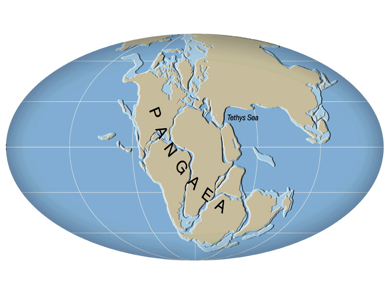
Panthalassa Ocean and Tethys Sea | Panthalassa Ocean and Tethys Sea | ||
| + | ==Topographic Features== | ||
'''Major Topoggraphic Features''' | '''Major Topoggraphic Features''' | ||
| − | *Mountains - Ancestral Rockies, Hercynian , and Ural System | + | *Mountains - Ancestral Rockies, Appalachian, Hercynian , and Ural System |
| + | *The interior of what is now North America was mostly plains such as the Interior Lowland Plateaus, the Central Lowland, the Great Plains, the Manitoba Lowlands, the Prairie Grassland, the Northern Boreal Plains, the Mackenzie Delta and the Southern Boreal Plains and Plateau. | ||
| + | |||
| + | <ref>[http://www.ehow.com/info_8107842_landforms-were-paleozoic-era.html]. </ref>, | ||
http://www.scotese.com/paleocli.htm | http://www.scotese.com/paleocli.htm | ||
| + | |||
| + | ==Climate Zones== | ||
| + | |||
| + | Gantgea has many climates due it it's size and location on the planet. It has ET (Polar Tundra), Dfc (snow, humid, cool summer), Bwk (arid, winter dry, cool arid, Cfa (warm temperate, fully humid, hot summer). <ref>[http://koeppen-geiger.vu-wien.ac.at/].</ref> | ||
| + | |||
| + | ===Factors that affect the climate of Gantgea:=== | ||
| + | |||
| + | Gantgea is completely surrounded by an ocean, Panthalassa, and stretches from the North pole almost to the South pole. For this reason we are able to find a wide range of climates on Gantgea. A portion of the north and south, is covered by glaciers. The Ancestral Rockies runs from N to S along the west coast of what is now N. America. This mountain chain causes a rain shadow on the eastern side causing the Interior Plains to be a BWk climate region. Other areas are swampy (Cfa). | ||
| + | Coastal areas are strongly influenced by ocean currents causing the north west coastal area (Cfb) to be cooler than the north east (Dfa). Conditions are reversed in the southern hemisphere. <ref> http://geography.about.com/library/weekly/aa011700b.htm </ref>, | ||
| + | |||
| Line 25: | Line 52: | ||
http://geology.com/pangea.htm | http://geology.com/pangea.htm | ||
| − | + | ||
| + | |||
| + | <references/> | ||
Latest revision as of 11:37, 29 February 2012
Earth Science 7-Global Regions
Contents
Gantgea
Countries(in this case continents)
You name it, I've got it.
Latitude and Longitude
Latitude Range 90 degrees N to 75 degrees S
Longitude Range 90 degrees W to 20 degrees E (at the equator)[2],
Elevation Range
Elevation Range While the exact elevations of the highest and lowest points were difficult to determine, this interactive site will allow one to see the general topography of Gantgea. [3],
http://www.scotese.com/Pangea2d.htm
Large Bodies of Water Panthalassa Ocean and Tethys Sea
Topographic Features
Major Topoggraphic Features
- Mountains - Ancestral Rockies, Appalachian, Hercynian , and Ural System
- The interior of what is now North America was mostly plains such as the Interior Lowland Plateaus, the Central Lowland, the Great Plains, the Manitoba Lowlands, the Prairie Grassland, the Northern Boreal Plains, the Mackenzie Delta and the Southern Boreal Plains and Plateau.
[4],
http://www.scotese.com/paleocli.htm
Climate Zones
Gantgea has many climates due it it's size and location on the planet. It has ET (Polar Tundra), Dfc (snow, humid, cool summer), Bwk (arid, winter dry, cool arid, Cfa (warm temperate, fully humid, hot summer). [5]
Factors that affect the climate of Gantgea:
Gantgea is completely surrounded by an ocean, Panthalassa, and stretches from the North pole almost to the South pole. For this reason we are able to find a wide range of climates on Gantgea. A portion of the north and south, is covered by glaciers. The Ancestral Rockies runs from N to S along the west coast of what is now N. America. This mountain chain causes a rain shadow on the eastern side causing the Interior Plains to be a BWk climate region. Other areas are swampy (Cfa). Coastal areas are strongly influenced by ocean currents causing the north west coastal area (Cfb) to be cooler than the north east (Dfa). Conditions are reversed in the southern hemisphere. [6],
 ).
).