Earth Science 7-1 Africa
Contents
- 1 Africa
- 2 African Countries
- 3 African Latitude and Longitude
- 4 Bordering Oceans
- 5 Large Bodies of Water, Rivers
- 6 Elevation Range, highest/lowest points
- 7 Major Topographic Features
- 8 Climate Zones
- 9 Average Monthly Precipitation
- 10 Average Monthly Temperature, highest/ lowest
- 11 Effect of Latitude on Climate
- 12 Effect of Elevation on Climate
- 13 Effect of Topography on Climate
- 14 Effect of the Proximity to Water on Climate
- 15 Effect of Prevailing Winds on Climate
- 16 Effect of Vegetation on Climate
- 17 Effect of High or Low Pressure Zones on Climate
- 18 Effect of Ocean Currents on Climate
- 19 Current African Natural Disasters
- 20 Geology
- 21 Plate Tectonics
- 22 Earthquakes
- 23 Types of Rock and Relationship to Tectonic Activity
Africa
By Cam Cook, Peter Stone and Sarah VanLoh
African Countries
South Africa, Botswana, Namibia, Zimbabwe, Zambia, Angola, Mozambique, Tanzania, Democratic Republic of the Congo, Congo, Gabon, Cameroon, Central African Republic, Chad, Sudan, Egypt, Libya, Niger, Nigeria, Algeria, Tunisia, Mali, Morocco, Western Sahara, Mauritania, Senegal, Gambia, Guinea Bissau, Guinea, Sierra Leone, Liberia, Ivory Coast, Ghana, Togo, Benin, Madagascar, Eritrea, Djibouti, Malawi, Lesotho, Swaziland, Rwanda Burundi, Kenya, Uganda, Somalia, Ethiopia, Burkina Faso, Canary Islands, Cape Verde, Equatorial Guinea, Sao Tome and Principe, Comoro [1]
African Latitude and Longitude
51 degrees West to 18 degrees East, 33 degrees South to 37 degrees North [1]
Bordering Oceans
Atlantic Ocean, Indian Ocean, Mediterranean Sea, Red Sea, Arabian Sea [1]
Large Bodies of Water, Rivers
Lake Victoria, Zambezi River, Orange River, Lake Nyasa, Lake Tanganyika, Congo River, White Nile River, Blue Nile River, Nile River, Niger River, Benue River, Volta River [1]
Elevation Range, highest/lowest points
Lac' Assal (lowest) -155 meters, Kilimanjaro (highest) 5895 meters [1]
Major Topographic Features
Sahara Desert, Lac' Assal, Great Rift Valley,Kalahari Desert, Namib Desert, Congo Basin, Kilimanjaro, Victoria Falls [1]
Climate Zones
Humid Subtropical (CWa), Subtropical Desert (BWh), Tropical Monsoonal (Am), Tropical Savanna (Aw), Subtropical Steppe (BSh), Mid-lattitude Desert (BWk), Mid-lattitude Steppe (BSk), Marine West Coast (Cfb), Humid Subtropical (Cfa) [2]
Average Monthly Precipitation
0 inches( Sahara Desert and part of Southern Africa), 1 inch ( Southern Africa and a little bit of near the edges of the Sahara Desert), 2 inches ( Part of Southern Africa, Western Africa, and a little bit in Northern Africa), 3 inches (part of Southern Africa and part of Central Africa), 4 inches ( a little bit of Central Africa), 5 inches ( Central Africa), 6 inches (Central Africa), 7 inches (Central Africa), 8 inches (Central Africa), 9 inches ( a tiny bit of Central Africa) [3]
Average Monthly Rainfall
250 millimeters per month [4]
Average Monthly Temperature, highest/ lowest
Average high temp: 81
Average low temp: 56 [9]
Effect of Latitude on Climate
Most of Africa gets little rain and is very hot due to the fact that it is in the mid latitudes and some of it is on the equator.
The Sahara Desert, the hottest and driest part of Africa, is located around 30 degrees North latitude near the Horse Latitudes, where the hot air sinks which makes little to no wind or rain. [5]
Effect of Elevation on Climate
The Sahara Desert is very flat which causes it to remain warm all of the year.  In the higher elevation, like Mt. Kilimanjaro,
there can be snow most of the year, and weather stays relatively cool.  Most of Africa is in between these elevations, so
weather changes per season in these areas and has relatively moderate weather and climate. Air pressure is also very low in high areas and very high in flat areas. [5]
Effect of Topography on Climate
Africa has a very diverse topography. In areas that are desert-like, the climate is very hot because the ground radiates the heat that it absorbs. In areas near lakes or rivers or the ocean, the coolness of the water keeps the land around it nice and cool as it goes under the hot air rising from the land. There is very little wind in the deserts but there is wind near water as the cool air over the water goes towards land. In mountainous areas, there can be winds due to valley and mountain breezes. It also stays cool on mountains due to its altitude. [5]
Effect of the Proximity to Water on Climate
In areas right on water, the water cools the land by sea breezes and the air is very humid. In areas near the center of Africa, where there isn't much water, the climate remains mostly hot and dry such as in the Sahara Desert. This is part of the reason why there is so much desert in the center of the continent and not near the ocean. [5]
Effect of Prevailing Winds on Climate
North of the Equator, the prevailing winds go from 30 degrees North to the Equator from the high to the low and curve to the right due to the Coriolis Effect. The same thing occurs South of the Equator except the winds curve to the left. These cause the hot air to heat the areas that it goes over and likewise with the cool air. The Trade Winds also occur in Africa between 30 degrees and the Equator in both hemispheres. These heat the land that they travel over and make the land windy. [6]
Effect of Vegetation on Climate
In areas where the vegetation is thickest, the land is cooler because the vegetation absorbs much of the heat that hits the ground. In areas with little vegetation, it stays hotter because land without vegetation radiates the heat. Vegetation helps to absorb sunlight to make photosynthesis. [5]
Effect of High or Low Pressure Zones on Climate
In low pressure zones, the air heats and rises which causes the land around it to be quite hot. In high pressure zones, the air sinks and cools which causes land to cool as well. The Equator is a low pressure area so everything around it is hot. Everything near 30 degrees latitude in both hemispheres are high pressure areas which causes the cool air to sink and cool the land around it. [5]
Effect of Ocean Currents on Climate
On the Western side of Africa, in the Atlantic Ocean, the water currents are moving towards the Equator. This means that the current is carrying cold water to the Equator where it will be heated. This cold water current cools the land beside it. On the Eastern side of Africa, in the Indian Ocean, the currents are moving away from the Equator which means that the water is warm. This causes the land next to it to warm up. [7]
Current African Natural Disasters
Nyamulagira Volcano erupted in the Democratic Republic of the Congo in Virunga National Park but is not moving fast enough to cause harm to wildlife or humans.  This volcano is the most active in Africa  and erupts every 2 years and erupts from days to months straight.
It also reached 116 degrees Fahrenheit in Skukuza, South Africa, due to its nearness to 30 degrees and the Horse Latitudes and that it is inland. [8]
Geology
 [15]
[15]
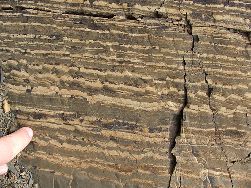
Rock Types
Africa is made up of Precambrian metamorphic and granitic rock, with a thin layer of sedimentary rock covering it which occupies shallow basins. The oldest rocks are gneisses, granites, metasediments, and metavolcanic rocks that are 3.6 to 2.5 billion years old. All of them are metamorphosed and deformed to some extent. The metamorphic rocks are found underneath sedimentary rocks because the weight of the sedimentary rock causes pressure which makes the underlying rock metamorphose. The sedimentary is the top layer because sediments are laid down over many years and are cemented together. The best preserved older rocks are in the Kaapvaal and Zimbabwe cratons and have large deposits of gold and sulfide minerals. Volcanic suites have a lot of basaltic and komatiitic lavas that have metasediments and are called greenstone belts. These belts are usually found with layered gneisses or are intruded by granitoid plutons. These plutons then cool to become igneous rocks. They are uncovered after years of weathering of the rocks which lie over them. Some igneous rocks make up various rock formations such as batholiths, laccoliths, volcanic necks, sills and dikes which form when magma works its way up towards Earth's surface and hardens. Igneous rocks can either be found deep under ground, or at or near the surface depending on whether they are extrusive or intrusive, or how much rock above it is weathered away. [11] [12]
 [17]
[17]
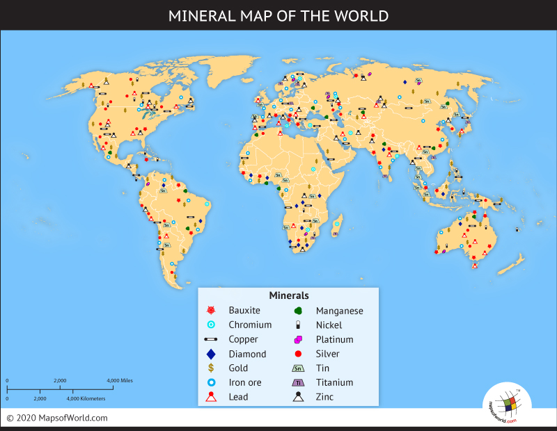
Minerals
The primary minerals in Africa are uranium, iron, oil, lead, zinc, iron, diamond, baoxite, coal, copper, gold. Oil is mainly found in northern Africa, in the Sahara Desert and a small portion in the southern tip of the continent. Uranium is found in the north central area of Africa, Niger. It is also found in South Africa and Namibia. A large portion of the gold found in Africa is from South Africa. The other areas where gold is found is central Africa and in the very northern part of the continent. Zinc and lead are found mostly in Namibia and a little in northern Africa. Iron is primarily found northwestern Africa and a small portion in South Africa. Bauxite is found in northwest Africa. There is not much coal in Africa. What is there can be found in northwest Africa, mid-Africa and southeast Africa. Copper is mainly found in southern Africa. Lastly, diamonds are found in DRC, Namibia, Botswana and South Africa. Regarding the formation of these minerals, diamonds and coal are both connected to organic sedimentary rocks. Gold is connected to sedimentary and igneous rocks. Oil is connected to sedimentary rock. [10] [14]
 [10]
[10]
Mining Resources
Africa mines more than 60 metals and minerals. It is a major producer of important metals and minerals including Gold, PGE’s, Diamonds, Uranium, Manganese, Chromium, Nickel, Bauxite and Cobalt. Though, Africa's contribution to the world's most important metals (lead, zinc and copper) is less than 7%. Silver production is very low (less than 3% of the world's) because most silver is made as a by product of lead-zinc and copper mining. Africa holds about 30% of the world's mineral reserves including 40% of gold, 60% of cobalt and 90% of the world's PGM reserves. This makes it a strategic producer of these metals. The increase in exploration and mine development has mainly been focused of gold and silver exploration. Due to the fact that base metal prices are increasing, the area may see a lot more activity. Mozambique, Nigeria and Madagascar are a few countries that have a huge potential for base and industrial mineral deposits. South Africa, Ghana, Zimbabwe, Tanzania, Zambia and the Democratic Republic of the Congo control Africa's mining industry, but countries like Angola, Sierra Leone, Namibia, Zambia and Botswana rely greatly on mining as a large foreign currency earner. Tragically, many African civil wars are funded and caused by these materials, especially diamonds, which are commonly referred to as "blood diamonds." New mines, and those currently under development, can be found in South Africa, Namibia, Botswana, Tanzania, and Gabon, and are producing gold, diamonds, niobium products, PGE’s, chrome and base metals. Several new discoveries over the last year include the potentially diamondiferous kimberlites in Mauritania and the potential marine deposits in offshore southern Namibia. Most diamond mines are found near rivers in southern Africa. The oil reserves are primarily in the Sahara Desert region. Uranium mines are mainly found in the great plains area of the central Kalahari area of Botswana. Overall, most mines in Africa would be found in the flat plains or desert regions as that is what primarily makes up the topography of Africa. [13] [10]
 [16]
[16]
Plate Tectonics
The only plate that Africa s located on is the African Plate. [18]
Boundary Types
The main type of boundary on the African Plate is divergent. There is also a little bit of transform and convergent boundaries in the northern part of the African Plate. [18]
Margin Types
The African margins are mostly passive, but some of the coast in the Northern Africa along the Red Sea and the Mediterranean Sea are active margins. [18]
Volcanoes
Africa has many volcanoes on its continent. They are located mainly in the the rift valley zone in Central Africa, Northeastern Africa, Western Africa mainly along the coast, off of the western coast of Africa in the Atlantic Ocean, in Madagascar, and in Northern Africa in the Sahara desert region. Some examples of volcanoes in the rift valley are the Korath Range, The Barrier, the Nyambeni Hills, and the Bishoftu Volcanic Field. Some examples of volcanoes in Western Africa are Mount Camaroon and Tombel Graben. Some of the examples of volcanoes off of the western coast of Africa are the San Carlos Volcano and the Santa Isabel Volcano. Some examples of volcanoes in Madagascar are the Ankaizina Field, the Atakor Volcanic Field and the Naraj Volcano. The types of volcanoes in Northeast Africa are shield volcanoes, stratovolcanoes, cinder cones and tuff cones. The types in East Africa are stratovolcanoes, shield volcanoes, tuff cones and pumice cones. The types of volcanoes in Central Africa are cinder cones, stratovolcanoes, shield volcanoes and tuff cones. The types of volcanoes in Western Africa are shield volcanoes, stratovolcanoes, and cinder cones. The types of volcanoes in Northern Africa are cinder cones, pyroclastic cones and shield volcanoes. Basaltic magma is located mainly in shield volcanoes. Rhyolitic magma is found in cinder cones, tuff cones, pumice cones , and pyroclastic cones. Andesitic magma is found in stratovolcanoes. The most recent eruptions of African volcanoes are Niragonogo in 2002, Nyamuragira in November 2010, Mugogo in1957, Erta Ale in 1967, and Mount Camaroon in 1959. [18] [19] [20] [21] [22]
Earthquakes
africa has many earthquakes on its continent.There is a lot of earthquakes on the western coast of Africa, and the north coast of Africa at a divergent boundary, and there is some earthquakes in the inland of Africa.All recent earthquakes- between 4/21/12 and 4/19 there was a series of earthquakes between 4.5 and 5 in the Iran/Iraq border. There was also a magnitude of 7 earthquake in Mozambique in 2006 and on 4/17/12 east of the South Sandwich Islands with a magnitude of 6.2.The most significant earthquakes in african history was a 7.1 magnitude quake in 1995 in Egypt, the crete earthquake estimated to be over 8 on the Richter scale in AD 365, and the 2003 Bourmedés earthquake which had a magnitude of 6.8. [24] [25] [26]
Types of Rock and Relationship to Tectonic Activity
The basaltic rock in africa has to do with the Cinder cones and shield volcanoes in Africa.[23]
References
    [1] https://www.cia.gov/library/publications/the-world-factbook/graphics/ref_maps/pdf/africa.pdf
    [2] http://www.shr.noaa.gov/jetstream/global/climate_max.htm
    [3] http://www.meteo.psu.edu/%7Enese/4_8_africa_precip.bmp
    [4] http://www.fao.org/docrep/X5318E/x5318e02.htm
    [5] Earth Science Textbook
    [6] http://kids.earth.nasa.gov/archive/nino/global.html
    [7] http://www.windows2universe.org/earth/Water/ocean_currents.html
    [8] https://www.sjs.org/ftpimages/80/download/HoustonChronicle11-13.pdf
    [9] http://www.eyesonafrica.net/africa-weather.htm
    [10] http://www.mapsofworld.com/world-mineral-map.htm
    [11] http://www.africaminerals.com/mineral_resources.htm
    [12] http://www.britannica.com/EBchecked/topic/7924/Africa/37126/Rock-types-and-structural-evolution
    [13] http://www.mbendi.com/indy/ming/af/p0005.htm
    [14] http://www.prospectorsparadise.com/html/geology.html
    [15] http://geology.com/world/africa-physical-map.shtml
    [16] http://www.willgoto.com/1/145203/liens.aspx
    [17] http://www.wired.com/wiredscience/2010/11/friday-field-photo-132-microfaulted-sedimentary-rock/
    [18] earth.google.com
    [19] http://www.volcano.si.edu/world/region.cfm?rnum=0205
    [20] http://www.uwec.edu/jolhm/EH3/Group1/Website/Sttratovolcano
    [21] http://www.volcanolive.com
    [22] http://vulcan.ur.usgs.gov/Volcanoes/Africa/description_africa_volcanics.html
    [23] http://sp.lyellcollection.org/content/207/1/21.abstract
    [24] http://www.preventionweb.net/files/7483_OCHAROCEAEarthquakesv2071219.pdf
    [25] http://earthquake.usgs.gov/earthquakes/recenteqsww/Maps/region/Africa_eqs.php
    [26] http://earthquake.usgs.gov/earthquakes/recenteqsww/Quakes/usjlca.php