Earth Science 7-4 South America
Contents
South America
By: Sunnie Liu, Arjun Guru, and Campbell Hinrichs
Geography
Countries
- Colombia
- Venezuela
- Guyana
- Suriname
- French Guiana
- Brazil
- Ecuador
- Peru
- Bolivia
- Paraguay
- Uruguay
- Argentina
- Chile
Latitude and Longitude Ranges
- Latitude: 12˚N-55˚S
- Longitude: 81˚W-35˚W
Elevation Range
- Lowest: 0 m (Sea Level)
- Highest: 6,960 m (Cerro Aconcagua, Argentina)
Large Bodies of Water and Rivers
Seas
- Caribbean Sea
- Scotia Sea
Lakes
- Lake Titicaca (Peru)
- Lake Maracaibo (Venezuela)
Gulfs
- Gulf of San Jorge (Argentina)
- Gulf of San Matias (Argentina)
- Gulf of Penas (Chile)
- Gulf of Guayaguil (Ecuador)
- Gulf of Paria (Venzuela)
- Gulf of Venezuela (Venezuela)
Strait
- Strait of Magellan (Chile)
River
- Amazon River (Central/Eastern S. America, 2 mouths in northeastern Brazil)
Passage
- Drake Passage
Major Topographic Features
Mountains
- The Andes Mountain Range
- Aconcagua Mountain(Argentina)
- It is the tallest mountain in the Western Hemisphere at 22,835 feet (6,960 meters).
- The Aconcagua is part of the Andes Mountain Range.
- Aconcagua Mountain(Argentina)
Regions
- The Altiplano
- This region is cold, windswept, and almost treeless.
- The Central Plains
- These plains cover roughly three-fifths of South America.
- They are divided into four areas
- Llanos: rolling grasslands
- Selva: lowland region covered with tropical rainforest
- Gran Chaco: hardwood scrub forest in north-central Argentina, western Paraguay, and southeastern Bolivia
- The other area of the Gran Chaco is the Pampas, a vast grassland of Argentina and Uruguay with fertile soil that supports many farms and ranches.
- The Eastern Highlands consist of two areas separated by the Amazon River Basin.
- The Guiana Highlands rise north of the Amazon Basin.
- They are 3,000-5,000 feet above sea level.
- The Guiana Highlands is covered with Tropical forests and open grasslands.
- They are thinly populated and largely underdeveloped.
- The Brazilian Highlands stretch South of the Amazon region to Southeastern Brazil.
- They cover nearly a fourth of the continent.
- The highest mountain in this region at 9,482 feet is northeast of Rio de Janeiro and is called Pico de Bandera
- But, most of the Brazilian Highlands consist of rounded hills and flat tablelands between 1,000 and 3,000 feet above sea level.
- The Southern Brazilian Highlands have fertile farmland, sufficient cattle ranches, and rich mineral deposits.
- The Guiana Highlands rise north of the Amazon Basin.
Waterfalls
- Angel Falls (eastern Venezuela)
- It is the largest waterfall in the world.
- It also has the longest drop of 3,212 feet.
- The water drops down a cliff, lands as mist, and drains into the Chúrun River.
- Cuquenán Falls (southeastern Venezuela)
- It is the world’s second highest waterfall, with a drop of 2,000 feet (610 meters).
- Iguaçu Falls (are on the border between Argentina and Brazil)
- Many people consider these falls the most magnificent natural sight in South America.
- The Iguaçu River forms Iguaçu Falls as it plunges 237 feet (72 meters) along an arc about 2 miles (3.2 kilometers) wide.
Deserts
- A coastal desert extends from southern Ecuador, along the coast of Peru, and meets the Atacama Desert of northern Chile.
- A much smaller desert covers the northern part of Colombia’s border with Venezuela.
- Patagonia, in southern Argentina, is a semidesert region.
- The Sertão of northeastern Brazil is a dry area covered with thorny bushes and low trees.
- Increasingly frequent droughts threaten to create a new desert there.
Tropical Rain Forests
- Tropical rain forests cover more than a third of South America.
- Dense rain forests blanket most of the warm, wet Amazon River Basin and the northeast and northwest coasts of the continent.
- Many valuable forest products come from the lush Amazon region.
- Large areas of coastal rain forest in Brazil have been cleared for farming and ranching.
- In these rain forests, most of the soil’s fertility comes from decaying leaves and causes the soil to be thin and poor.
- Dense rain forests blanket most of the warm, wet Amazon River Basin and the northeast and northwest coasts of the continent.
Islands
- The Galapagos Islands
- These islands belong to Ecuador and lie in the Pacific about 600 miles (970 kilometers) off the coast of that country.
- Marajo, an island at the mouth of the Amazon River, belongs to Brazil.
- Herders raise water buffaloes on this flat, grassy island.
- The Tierra del Fuego
- This group lies across the Strait of Magellan from the southernmost tip of the South American mainland.
- Argentina and Chile own them.
- Juan Fernandez Islands
- Chile also owns these islands in the Pacific, about 400 miles (640 kilometers) off Chile’s coast.
- The Falkland Islands
- They are an overseas territory of the United Kingdom and lie in the South Atlantic about 320 miles (515 kilometers) east of the southern coast of Argentina.
- Argentina also claims these islands and calls them the "Islas Malvinas."
Bordering Oceans
- Pacific Ocean
- Atlantic Ocean
Climate Zones
Af (tropical rainforest)
- Doesn't have a dry season
- The driest month has at least 2.40’’ (61 mm) of rain.
- Rainfall is usually evenly distributed throughout the year.
- All average monthly temperatures are greater than 64˚F (18˚C).
Am (tropical monsoonal)
- Has a distinct wet season and a short dry season
- One or more months have less than 2.40’’ (61 mm) of rain.
- All average monthly temperatures are greater than 64˚F (18˚C).
- The highest annual temperature precedes the rainy season.
Aw (tropical savanna)
- Has a dry winter season
- There are more than two months with less than 2.40’’ (61 mm) of rain.
- All average monthly temperatures are greater than 64˚F (18˚C).
Cfc (marine west coast)
- Is a mild mid-latitude climate
- Doesn't have a dry season
- Has a cool summer
- Average temperatures of all months are lower than 72˚F (22˚C).
- 1-3 months with average temperatures over 50˚F (10˚C).
- Evenly distributed rainfall throughout the year
Csc
- Is a mild mid-latitude climate
- Has a dry and cool summer season
Cwc
- Is a mild mid-latitude climate
- Has a dry winter season and a cool summer
Earthweek
Houston Chronicle 10-16-11
Over the recent weeks, the ozone hole over Antarctica has extended deeper into South America, causing hazardous amounts of ultraviolet radiation from the sun to reach the areas around Santiago, Chile. Three weeks ago, Santiago’s ultraviolet index hit an 8—the highest recorded for that specific time of the year since 2008. A 10% increase in ultraviolet radiation last January, with the ultraviolet index sometimes reaching above 12 was recorded for Chile’s capital city. According to Chile’s cancer institute, within the last decade, there has been an increase in the number of people that have skin cancer, which is directly associated with high ultraviolet levels.
Earth movements were felt in northern Argentina from the 6.1 magnitude earthquake of Bali, an Indonesian resort island.
Houston Chronicle 10-23-11
Up to 2,000 hammerhead, Galapagos, and whale sharks were massacred for their fins in Colombia’s territorial waters, around Malpelo Island. Costa Rica was asked by environmental authorities to help track down those responsible for the slaughter.
75 mph winds over Argentina whipped up volcanic ash clouds from the eruption by neighboring Chile’s Puyehue volcano. The fear that the debris could damage jet engines caused many airports in Argentina and Uruguay to shut down.
Houston Chronicle 11-6-11
Along the Peruvian central coast, a 6.9 magnitude earthquake injured 103 people. The same temblor wrecked over 1,000 adobe homes in the Inca region and an 18th century cathedral in the local capital.
In Chile, the Hudson volcano’s rumblings along with those of the Cordón Caulle volcano covered a huge part of neighboring Argentina in ash and upset air travel for many months. About 1,000 miles south of Santiago, Hudson ejected a column of steam and ash that shot up over 3 miles into the sky. Snow melted by the volcano’s interior heat caused the Aysen River to overflow its banks, forcing 119 people to evacuate.
In Chorro de Agua Caliente (“hot water jet”), an Argentine reservoir in the province of Córdoba with water that once cooled a nuclear power plant, a three-eyed fish was caught. The fishermen claim they will submit the fish for testing. The capture of the mutated fish inspired a Simpsons episode called “Two Cars in Every Garage and Three Eyes on Every Fish.”
In Mariscal Estigarribia, Paraguay, a record high of 110˚F was registered.
Houston Chronicle 11-13-11
In Chile’s Atacama Desert, wildflowers that bloomed during the area’s wettest winter in decades have emerged from the sand, around cacti, and out of cracks in rocks. 370 miles north of Santiago, Atacama Desert’s Llanos de Challes National Park is likely to be in springtime bloom until December. Over the past year, the near-record La Niña in the nearby tropical Pacific Ocean brought about 2 inches of rainfall to the park.
Factors that Affect the Climate of South America
Latitude
Almost-vertical rays from the sun hit areas near the equator all throughout the year, causing the areas around the equator to have hot climates. Therefore, Ecuador, Colombia, Venezuela, Guyana, Suriname, French Guiana, northern Brazil, and northern Peru all have warm climates. The low-pressure areas of the intertropical convergence zone (ITCZ) and the mid-latitudes have plenty have precipitation. In July, the areas of South America that have the equator running through them are in the ITCZ, causing those areas to have precipitation. In January, the northern half of South America is in the ITCZ, causing that half to have precipitation. The air sinks in the horse latitudes, the areas between 20 and 30 degrees latitude. Since sinking air can hold very little precipitation, the horse latitudes are dry with little precipitation, causing many deserts to form in the horse latitudes. Because the horse latitudes run through the middle of South America, the central areas have little precipitation.
Elevation
As altitude increases, the air becomes thinner and less capable of absorbing and retaining heat. Therefore, at higher elevations, the temperatures are colder. Also, air contains less moisture at higher elevations. In South America, low-lying areas, like the coast of Brazil by the Atlantic Ocean, have relatively high temperatures and humid climates. Whereas in mountainous areas, such as Cerro Aconcagua, Argentina, have relatively low temperatures and dry climates.
Proximity to Water
Since water cools and heats slower than land, the temperature range for large bodies of water is small, causing coastal areas to have relatively mild climates while causing inland areas to have more extreme climates. Also, large bodies of water add water vapor to the air, causing a greater chance of precipitation for areas nearby. Cartagena, a coastal city of Colombia, has an average temperature range of 26.7˚C (80.1˚F) – 28.1˚C (82.6˚F) and a total yearly rainfall of 37.4 in. (950.7 mm). La Paz, an inland city of Bolivia, has an average temperature range of 7.3˚C (45.1˚F) – 10.9˚C (51.6˚F) and a total yearly rainfall of 24.0 in. (610.3 mm). [9] [10]
Ocean Currents
Warm ocean currents warm nearby coasts while cold currents cool nearby coasts. Warm currents, such as the South Equatorial Current, Equatorial Countercurrent, and Brazil Current, cause all of the northern coast, the northwestern coast, and most of the eastern coast of South America to have warmer climates than they would otherwise. Cold currents, like the Peru Current and West Wind Drift, cause most of the western coast and the southeastern coast of South America to have cooler climates than they would otherwise.
Topography
Since mountainous areas have higher altitudes, they usually have cooler climates. For example, Chile has a colder climate than it would otherwise because of the Andes Mountain Range. The air traveling up the windward side cools at the moist-adiabatic lapse rate (approximately 6˚C per kilometer) while the air traveling down the leeward side warms at the dry-adiabatic lapse rate (about 10˚C per kilometer). Thus, the leeward side of the Andes Mountains is warmer than the windward side. When wind reaches the windward side, it is forced to rise. Since air cools as it rises, some of the water vapor condenses and may fall as precipitation. The rain or snow removes moisture from the air on the windward side, causing the leeward side to be very dry. Therefore, the windward side of the Andes Mountains is wetter than the leeward side. Mountains also act as barriers to air masses. When a cool, moist air mass reaches the Andes Mountain Range, it is forced up the windward side, losing moisture as it rises. The air mass sinks on the leeward side, where it is compressed and warmed. The now hot, dry air is over the Atacama Desert, the driest desert on earth.
Prevailing Winds
Prevailing winds determine if air masses arrive from a warm or cool region. These winds also determine if air masses arrive from a wet or dry region. The prevailing northeasterlies bring moist air masses from the warm tropical ocean, such as the maritime tropical (mT), to the areas of South America north of the equator. The prevailing southeasterlies bring humid air masses from the warm tropical ocean, like the maritime tropical (mT), and dry air masses from warm inland areas near the 30˚S latitude to the middle regions of South America. The prevailing northwesterlies bring moist air masses from the South Pacific Ocean to the southern tip of South America.
Vegetation
The vegetation affects the amount of insolation the earth’s surface absorbs and how fast the surface heats or cools. In the Atacama Desert of South America, there is little vegetation. Therefore, the surface absorbs heat quickly but also cools quickly. In the daytime, the temperatures are scorching hot, and at night, the temperatures drop rapidly. The vegetation also releases water vapor into air through transpiration. This makes the air more humid, causing an area with plenty of vegetation to have a wet climate. Since the Amazon Rainforest in Brazil is home to over five million different species of plants, the climate there is very moist.
High and Low Pressure Zones
When the temperatures are lower, the air molecules clump together more closely. Thus, an area of high pressure indicates cooler temperatures. When the temperatures are higher, the air molecules spread farther apart. Therefore, an area of low pressure indicates warmer temperatures. Also, a high pressure zone usually has dry air and a low pressure zone usually has humid air. Because the equator is in a low pressure zone and Ecuador, southern Colombia, northern Brazil, and northern Peru are all along the equator, most of these areas all have humid, warm climates (tropical wet). Part of the Amazon Rainforest is along the equator and thus, in a low pressure area, accounting for its warm, moist climate. Since the 30° latitude line is in a high pressure zone and central Chile, northern Argentina, northern Uruguay, and southern Brazil are along the 30° latitude line, these regions have cooler, drier climates. For example, central Chile and most of northern Argentina has a desert or semiarid climate (except for the Andes Mountains, which has a highland climate). The Atacama Desert is also along the 30° latitude line and therefore in a high pressure zone, accounting for its dry climate.
Average Monthly Precipitation and Temperature Highs/Lows
Iquitos, Peru (Af)
Average Monthly Precipitation
- Jan: 10.5 in (267.7 mm)
- Feb: 10.0 in (254.1 mm)
- Mar: 12.7 in (322.9 mm)
- Apr: 11.9 in (301.3 mm)
- May: 10.5 in (267.1 mm)
- Jun: 8.2 in (207.6 mm)
- Jul: 6.4 in (162.6 mm)
- Aug: 6.5 in (165.9 mm)
- Sep: 7.5 in (190.2 mm)
- Oct: 9.1 in (230.6 mm)
- Nov: 9.8 in (249.3 mm)
- Dec: 10.2 in (258.4 mm)
Average Monthly Temperature
- 26.1°C (79.0°F)
Highest Monthly Temperature
- 26.6°C (79.9°F)
Lowest Monthly Temperature
- 25.2°C (77.4°F)
Santarem, Brazil (Am)
Average Monthly Precipitation
- Jan: 8.1 in (205.1 mm)
- Feb: 11.6 in (295.4 mm)
- Mar: 15.2 in (385.0 mm)
- Apr: 14.5 in (367.3 mm)
- May: 11.2 in (285.7 mm)
- Jun: 5.0 in (127.8 mm)
- Jul: 3.5 in (87.7 mm)
- Aug: 1.7 in (42.2 mm)
- Sep: 1.2 in (29.9 mm)
- Oct: 1.4 in (34.5 mm)
- Nov: 2.8 in (70.5 mm)
- Dec: 4.3 in (109.4 mm)
Average Monthly Temperature
- 25.8°C (78.4°F)
Highest Monthly Temperature
- 26.8°C (80.2°F)
Lowest Monthly Temperature
- 25.2°C (77.4°F)
Brasilia, Brazil (Aw)
Average Monthly Precipitation
- Jan: 10.3 in (262.2 mm)
- Feb: 8.4 in (212.9 mm)
- Mar: 7.9 in (201.9 mm)
- Apr: 4.1 in (102.9 mm)
- May: 0.8 in (19.7 mm)
- Jun: 0.2 in (4.0 mm)
- Jul: 0.2 in (4.2 mm)
- Aug: 0.2 in (5.8 mm)
- Sep: 1.4 in (34.5 mm)
- Oct: 5.5 in (139.7 mm)
- Nov: 9.4 in (238.2 mm)
- Dec: 12.9 in (328.6 mm)
Average Monthly Temperature
- 20.6°C (69.1°F)
Highest Monthly Temperature
- 21.7°C (71.1°F)
Lowest Monthly Temperature
- 18.4°C (65.1°F)
Huayao, Peru (Cwc)
Average Monthly Precipitation
- Jan: 4.9 in (123.7 mm)
- Feb: 4.6 in (116.3 mm)
- Mar: 4.5 in (114.6 mm)
- Apr: 2.2 in (54.8 mm)
- May: 1.0 in (24.4 mm)
- Jun: 0.3 in (8.6 mm)
- Jul: 0.3 in (7.4 mm)
- Aug: 0.6 in (16.3 mm)
- Sep: 1.8 in (45.4 mm)
- Oct: 2.6 in (65.1 mm)
- Nov: 2.7 in (69.8 mm)
- Dec: 3.6 in (90.8 mm)
Average Monthly Temperature
- 11.2°C (52.2°F)
Highest Monthly Temperature
- 12.3°C (54.1°F)
Lowest Monthly Temperature
- 9.5°C (49.1°F)
Punta Arenas, Chile (Cfc)
Average Monthly Precipitation
- Jan: 1.4 in (35.4 mm)
- Feb: 1.1 in (28.1 mm)
- Mar: 1.5 in (39.3 mm)
- Apr: 1.6 in (41.0 mm)
- May: 1.7 in (42.4 mm)
- Jun: 1.3 in (32.4 mm)
- Jul: 1.3 in (33.8 mm)
- Aug: 1.3 in (33.1 mm)
- Sep: 1.1 in (27.5 mm)
- Oct: 0.9 in (23.6 mm)
- Nov: 1.1 in (28.8 mm)
- Dec: 1.2 in (31.5 mm)
Average Monthly Temperature
- 6.3°C (43.3°F)
Highest Monthly Temperature
- 10.8°C (51.4°F)
Lowest Monthly Temperature
- 1.7°C (35.1°F)
Santiago del Estero Aero., Argentina (Csc)
Average Monthly Precipitation
- Jan: 4.0 in (102.8 mm)
- Feb: 3.9 in (98.1 mm)
- Mar: 3.6 in (91.0 mm)
- Apr: 1.3 in (32.4 mm)
- May: 0.6 in (15.7 mm)
- Jun: 0.3 in (8.2 mm)
- Jul: 0.2 in (4.1 mm)
- Aug: 0.2 in (4.2 mm)
- Sep: 0.5 in (12.4 mm)
- Oct: 1.3 in (33.8 mm)
- Nov: 2.5 in (62.9 mm)
- Dec: 3.3 in (82.6 mm)
Average Monthly Temperature
- 20.6°C (69.1°F)
Highest Monthly Temperature
- 26.9°C (80.4°F)
Lowest Monthly Temperature
- 13.0°C (55.4°F)
Geology
Rock Types
Bolivia
Most of the rocks found in Bolivia are sedimentary due to the many rivers, especially in the northern part, and numerous lakes (Lake Poopo, Lake Titicaca, Lake Rogoaguado, and Lake Rogogua) spread throughout the country. There are a considerably smaller amount of igneous and metamorphic rocks than sedimentary rocks in Bolivia because there aren’t as many volcanoes and mountain building areas as lakes and rivers. But there are still some igneous rocks because there are a few volcanoes in Bolivia such as the Acotango Volcano, Escala Volcano, Licancabur Volcano, Minchincha Volcano, and the Olca Volcano. There are a few metamorphic rocks because of the "Transamazonian Tectono-Thermal Event" that happens millions of years ago in South America. [24]
Brazil
Much of the sedimentary rocks are found in north-western Brazil because of the Amazon Basin, where the drainage of the Amazon River and its tributaries are. Other sedimentary rocks are distributed throughout due to the rivers in Brazil (Sao Francisco River, Parana River, Paraguay River, and Uruguay River). Igneous and Metamorphic Rocks are found in the North, South, Central, and East. Igneous rocks are found in Brazil because of the Trindade Volcano that was active many years ago. Metamorphic rocks are found in Brazil because of the mountain building events related to the Neoproterozoic Brasiliano-Pan African orogenic cycle. [25]
Chile
There are some sedimentary rocks in Chile due to the rivers there. But mostly, there are igneous and metamorphic rocks due to the Andes Mountains. There are igneous rocks because of the many volcanoes like the Guallatiri Volcano, Irruputuncu Volcano, Lascar Volcano, and Isluga Volcano. There are metamorphic rocks because of the mountain Andean building events that formed the Andes Mountains and continue to this day and the pressure from where the South American and Nazca Plates meet. [26]
Colombia
A large amount of the rocks in Colombia are sedimentary rocks due to the large amounts of rivers flowing through Colombia. There are some igneous rocks because of the volcanoes like the Cumbal Volcano, Dona Juana Volcano, Galeras Volcano, and Nevado del Huila Volcano. There are metamorphic rocks because of the Andean mountain building activity and the pressure from the tension between South American Plate and the Nazca and Caribbean Plates. [27]
Ecuador
In Ecuador, a good amount of the rocks are sedimentary but there are many igneous and metamorphic rocks too. There are sedimentary rocks because of the Napo, Curaray, and Pastaza Rivers among others. There are igneous rocks because of the volcanoes in the area like the Antisana Volcano, Cayambe Volcano, Chiles Volcano, and Cotopaxi Volcano. There are metamorphic rocks because of the Andean mountain building activity and the pressure from the tension between the Nazca and South American plates. [28]
Paraguay
Almost all the rocks in Paraguay are sedimentary because of the many rivers that run through the country. There are a few pockets of igneous and metamorphic rocks in the south-eastern part of Paraguay. There are few igneous rocks because there aren’t any currently active volcanoes there. There are few metamorphic rocks due to the fact that Paraguay doesn’t lie on a boundary between two plates or is in a mountain-building area. [29]
Peru
The amounts of sedimentary rock and igneous and metamorphic rock are about the same. There are sedimentary rocks due to the rivers (Amazon River among others) and the lakes (Lake Titicaca among others). There are igneous rocks because of volcanoes like the Coropuna Volcano, Sabancaya Volcano, and Ubinas Volcano. There are metamorphic rocks because Peru lies on the boundary between the South American and Nazca plates and the Andean mountain building activity. [30]
Uruguay
There are more igneous and metamorphic rocks than sedimentary rocks because Uruguay is located in the volcanic province of the Paraná River basin and mountains, including Cerro Catedral, Sierra del Soldado, and Cerro Espuelitas. The igneous and metamorphic rocks are located in the North and the South, but not in the East or the West. There are still some sedimentary rocks in the East, the West, and pockets in the South due to the rivers and lakes like Rio Negro, Rio de la Plata, and Laguna Marin. [31]
Venezuela
In Venezuela, most of the rocks are sedimentary with a few pockets of igneous and metamorphic rocks. The sedimentary rocks are spread throughout the country while the pockets of igneous and metamorphic rocks are in the North and in the middle. There are a bigger amount of sedimentary rocks than igneous and metamorphic rocks because of the many rivers that run through Venezuela like the Orinoco River, Caura River, Apure River, and Arauca River and the mud volcanoes. But there are still some igneous and metamorphic rocks because of mountain building in the area and the pressure from the tension between the Caribbean and South American plates. [32]
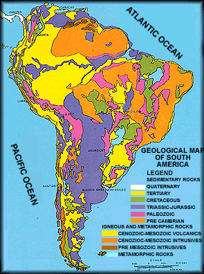
NOTE: Information above about the rock types in the South American countries does not come from this geological map of South America so information may differ.
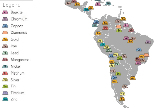
Minerals
- Bauxite: Suriname, Brazil
- Chromium: Brazil
- Copper: Brazil, Peru, Chile
- Diamonds: Brazil, Venezuela
- Gold: Chile, Ecuador, Brazil, Colombia, Argentina, Venezuela, Uruguay
- Iron: Argentina, Brazil, Bolivia, Chile, Venezuela
- Lead: Argentina, Peru
- Manganese: Brazil
- Nickel: Pacific Ocean off the coast of Colombia
- Platinum: Colombia
- Silver: Peru, Bolivia, Chile, Argentina
- Tin: Venezuela, Bolivia, Argentina
- Zinc: Peru
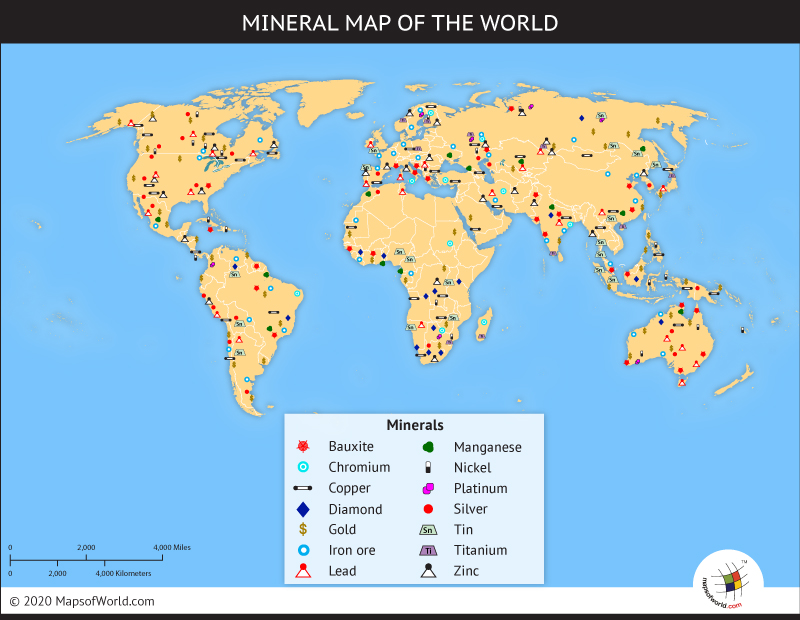
NOTE: Information about minerals above does not come from this mineral map so information may differ.
Mining Resources
Mining in the Countries
- Colombia: petroleum, natural gas, coal, iron ore, nickel, gold, copper, emeralds
- Venezuela: petroleum, natural gas, iron ore, gold, bauxite, diamond
- Guyana: bauxite, gold, diamond
- Suriname: kaolin, bauxite, gold, nickel, copper, platinum, iron ore
- French Guiana: gold, petroleum, kaolin, niobium, tantalum, clay
- Brazil: bauxite, gold, iron ore, manganese, nickel, phosphates, platinum, tin, uranium, petroleum
- Ecuador: petroleum
- Peru: copper, silver, gold, petroleum, iron ore, coal, phosphate, potash, natural gas
- Bolivia: tin, natural gas, petroleum, zinc, tungsten, antimony, silver, iron, lead, gold
- Paraguay: iron ore, manganese, limestone
- Uruguay: minor minerals
- Argentina: lead, zinc, tin, copper, iron ore, manganese, petroleum, uranium
- Chile: copper, iron ore, nitrates, precious metals, molybdenum
Mining Trends
The mining in South America isn't all in the mountains, all by the ocean, or all near rivers. Instead, the mining is spread out.
- Near rivers
- Magdalena River: gold, platinum
- Orinoco River: iron, diamonds, tin
- Amazon River: bauxite, iron, gold
- Sao Francisco River: chromium, copper
- Parana River: manganese, gold, bauxite, iron
- Rio de la Plata: gold
- Andes Mountains: gold, silver, zinc, lead, copper, iron
- Amazon rain forest: silver, zinc, lead, tin, iron, copper, gold, bauxite, diamonds, manganese, platinum
- Near oceans and seas
- Pacific Ocean: gold, silver, zinc, lead, copper, iron, nickel
- Caribbean Sea: bauxite, gold, iron
- Atlantic Ocean: chromium, diamonds, gold, iron, manganese, bauxite, silver
Tectonic Plates
Plates
- South American Plate
- Caribbean Plate
- Cocos Plate
- Nazca Plate
- Scotia Plate
- African Plate
- Antarctic Plate.
NOTE: These are the plates surrounding/in the South America region. [39]
Boundary Types
- Caribbean/South American plate boundary: Subduction (Oceanic-Continental)
- Nazca/South American plate boundary: Subduction (Oceanic-Continental)
- Scotia/South American plate boundary: Complex or Undefined-mostly Transform with some Subduction (Oceanic-Oceanic) and some Divergent
- African/South American plate boundary: mostly Divergent with breaks of Transform
- Antarctic/South American plate boundary: Complex or Undefined-(East) some Divergent and some Transform, (West) some Subduction (Oceanic-Continental)
- Cocos/Nazca plate boundary: Subduction (Oceanic-Continental)
- North American/South American: Undefined or Complex
Margin Types
- Northwest coast (Caribbean/South American plate boundary): Active
- Northeast coast: Passive
- Southern tip (Scotia/South American plate boundary): Active
- East coast: Passive
- West coast (Nazca/South American plate boundary, Antarctic/South American plate bounary): Active
Volcanoes
South America does have volcanoes and they are located in Argentina, Bolivia, Chile, Colombia, and Peru. Due to the oceanic-continental plate subduction between the South America plate and the Nazca, Caribbean, Cocos, and Antarctic plates, many volcanoes form along the overriding continental plate. Therefore, the west coast of South America has many volcanoes. Most of the volcanoes are composite volcanoes because these volcanoes form on the overriding continental plate in an oceanic-continental plate subduction zone. Generally, composite volcanoes are associated with andesitic magma. [42]
- Copahue: Argentina-Chile border, composite volcano with an 8-km-wide caldera, andesitic magma[43]
- Illimani: Bolivia, extinct composite volcano, andesitic magma[44]
- Parinacota: Chile-Bolivia frontier, composite volcano, andesitic magma[45]
- Sajama: Boliva, composite volcano, andesitic magma[46]
- Guallatir: northern Chile, composite volcano, andesitic magma[47]
- Lascar: Chile, composite volcano with series of 6 overlapping craters, andesitic magma[48]
- Ojos del Salado: Chile, composite volcano, andesitic magma[49]
- Tocorpuri and La Torta: Chile-Bolivia border, composite volcano (Tocorpuri) with andesitic magma, rhyolitic volcanic dome (La Torta)[50]
- Villarrica: Chile, open-system composite volcano, basaltic-andesitic magma[51]
- Galeras: Colombia, composite volcano, andesitic magma[52]
- Nevado del Ruiz: Colombia, composite volcano, andesitic magma[53]
- Purace: Colombia, composite volcano, andesitic magma[54]
- Sabancaya: Peru, composite volcano, andesitic magma[55]
- Chimborazo: Ecuador, composite volcano, andesitic magma[56]
- Cotopaxi: Ecuador, composite volcano, andesitic magma[57]
- Guagua Pichincha: Ecaudor, composite volcano with a 1.6-mile-diatmeter caldera, andesitic magma[58]
- Iliniza: Ecuador, composite volcano, andesitic magma[59]
- Mojanda: Ecuador, composite volcano, andesitic magma[60]
- Reventador: Ecuador, composite volcano, andesitic magma[61]
- Sangay: Ecuador, composite volcano, andesitic magma[62]
- Sumaco: Ecuador, composite volcano, andesitic magma[63]
- Tungurahua: Ecuador, composite volcano, basaltic-andesitic magma[64]
Recent Volcanic Eruptions
- 6/4/11-ongoing: Puyehue-Cordon Caulle (Chile, Argentina)
- 2010-ongoing: Villarrica (Chile, Argentina)
- 4/17/12-ongoing: Sangay (Ecuador)
- 2000-ongoing: Tungurahua (Ecuador)
- 4/19/12-ongoing: Nevado del Ruiz (Colombia)
- 2/2/12-ongoing: Puntiagudo-Cordon Cenizos (Chile, Argentina)
- 4/19/12-ongoing: Reventador (Ecaudor)
NOTE: The information shown above is about the volcanoes that are currently erupting and their locations.
Volcanic Eruptions History
- 05/02/2008: Chaiten
- 11/03/2002: Reventador
- 01/30/1993: Lascar
- 06/11/1968: Fernandina
- 07/27/1955: Carran-Los Venados
- 03/03/1916: Tungurahua
- 11/01/1897: Dona Juana
- 01/07/1893: Calbuco
- 01/11/1886: Tungurahua
- 01/01/1877: Cotopaxi
- 08/08/1991: Cerro Hudson
- 04/21/1932: Cerro Azul
- 02/17/1600: Huaynaputina
Earthquakes
The region of South America does have earthquakes. The earthquakes in South America tend to occur on the west coast because it is on the subduction boundary between the South America plate and the Nazca, Cocos, and Antarctica plates. Due to the oceanic-continental subduction occurring, earthquake depths are shallow next to the boundary but get deeper farther inland. But, some earthquakes occur on the Northwest coast due to the subduction boundary between the South America plate and the Caribbean plate.
Recent Earthquakes
- 4/20/2012: 4.8 Central Peru
- 4/19/2012: 4.7 Coquimbo, Chile
- 4/19/2012: 4.4 El Salvador
- 4/18/2012: 4.5 Guatemala
- 4/18/2012: 4.6 Panama
- 4/17/2012: 4.5 Near coast of southern Peru
- 4/17/2012: 6.7 Offshore Valparaiso, Chile
- 4/14/2012: 5.0 West Chile Rise
- 4/14/2012: 6.2 Drake Passage
- 4/13/2012: 4.5 Potosi, Bolivia
- 4/13/2012: 4.6 Guatemala
- 4/13/2012: 4.6 Maule, Chile
NOTE: The format of this information is date, magnitude, then area where the earthquake occurred.
Significant Earthquakes in History
- 01/18/1906: 8.8 Ecuador
- 08/17/1906: 8.6 Chile
- 11/11/1922: 8.4 Chile
- 12/01/1928: 8.0 Chile
- 05/14/1942: 7.9 Ecuador
- 08/24/1942: 8.1 Peru
- 04/06/1943: 8.3 Chile
- 05/24/1960: 9.5 Chile
- 11/20/1960: 7.6 Peru
- 10/17/1966: 8.1 Peru
- 10/03/1974: 8.0 Peru
- 12/12/1979: 8.1 Ecuador
- 03/03/1985: 8.0 Chile
- 07/30/1995: 8.1 Chile
- 11/12/1995: 7.7 Peru
- 02/21/1996: 7.5 Peru
- 06/23/2001: 8.4 Peru
- 07/07/2001: 7.5 Peru
- 08/15/2007: 8.0 Peru
- 11/14/2007: 7.7 Chile
NOTE: The format of this information is date, magnitude, then area where the earthquake occurred.
Rock Types and Plate Tectonics
The igneous rocks in South America includes andesite. Therefore, many of the volcanoes formed by plate tectonics activity (oceanic-continental subduction between the South America Plate and the Nazca, Cocos, and Antarctica plates) have andesitic magma and are composite volcanoes because these volcanoes are associated with andesitic magma. Also, the name of the rock "Andesite" originates from the Andes Mountain range in South America, which was formed by plate tectonics activity (ocean-continental subduction).
References
- ↑ http://memory.loc.gov/frd/cs/continent_americas.html \
- ↑ South America. Map. Google Earth. Google.com, 3 Nov. 2011. Web. 2 Nov. 2011.
- ↑ https://www.cia.gov/library/publications/the-world-factbook/fields/2020.html#52
- ↑ http://www.worldatlas.com/webimage/countrys/samerica/samera.htm
- ↑ http://www.worldbookonline.com/advanced/article?id=ar520980&st=south+america
- ↑ https://www.cia.gov/library/publications/the-world-factbook/maps/refmap_south_america.html
- ↑ http://www.srh.noaa.gov/jetstream/global/climate_max.htm
- ↑ http://www.earthweek.com
- ↑ http://www.worldclimate.com/cgi-bin/grid.pl?gr=N10W075
- ↑ http://www.worldclimate.com/cgi-bin/grid.pl?gr=S16W068
- ↑ Spaulding, N. E. & Namowitz, S. N. Earth Science. McDougal Littel Inc: Evanston, IL. 2005.
- ↑ http://www.worldclimate.com/cgi-bin/data.pl?ref=S03W073+2100+84377W
- ↑ http://www.worldclimate.com/cgi-bin/data.pl?ref=S03W073+1102+84377W
- ↑ http://www.worldclimate.com/cgi-bin/data.pl?ref=S02W054+2100+82244W
- ↑ http://www.worldclimate.com/cgi-bin/data.pl?ref=S02W054+1102+8224402G1
- ↑ http://www.worldclimate.com/cgi-bin/data.pl?ref=S15W047+2100+8338401G1
- ↑ http://www.worldclimate.com/cgi-bin/data.pl?ref=S15W047+1102+83377W
- ↑ http://www.worldclimate.com/cgi-bin/data.pl?ref=S12W075+2100+84630W
- ↑ http://www.worldclimate.com/cgi-bin/data.pl?ref=S12W075+1102+84630W
- ↑ http://www.worldclimate.com/cgi-bin/data.pl?ref=S53W070+2100+85934W
- ↑ http://www.worldclimate.com/cgi-bin/data.pl?ref=S53W070+1102+85934W
- ↑ http://www.worldclimate.com/cgi-bin/grid.pl?gr=S27W064
- ↑ http://www.worldclimate.com/cgi-bin/data.pl?ref=S27W064+1102+87129W
- ↑ http://geology.about.com/od/othernationgeomaps/ss/South-America-Geologic-Maps_2.htm
- ↑ http://geology.about.com/od/othernationgeomaps/ss/South-America-Geologic-Maps_3.htm
- ↑ http://geology.about.com/od/othernationgeomaps/ss/South-America-Geologic-Maps_4.htm
- ↑ http://geology.about.com/od/othernationgeomaps/ss/South-America-Geologic-Maps_5.htm
- ↑ http://geology.about.com/od/othernationgeomaps/ss/South-America-Geologic-Maps_6.htm
- ↑ http://geology.about.com/od/othernationgeomaps/ss/South-America-Geologic-Maps_9.htm
- ↑ http://geology.about.com/od/othernationgeomaps/ss/South-America-Geologic-Maps_10.htm
- ↑ http://geology.about.com/od/othernationgeomaps/ss/South-America-Geologic-Maps_13.htm
- ↑ http://geology.about.com/od/othernationgeomaps/ss/South-America-Geologic-Maps_14.htm
- ↑ http://petroinca.tripod.com/sageol.htm
- ↑ http://maps.howstuffworks.com/world-energy-minerals-map.htm
- ↑ http://www.mapsofworld.com/world-mineral-map.htm
- ↑ https://www.cia.gov/library/publications/the-world-factbook/fields/2111.html
- ↑ http://conworld.wikia.com/wiki/File:South_America_Mining_Map.png
- ↑ http://conworld.wikia.com/wiki/File:South_America_Mining_Map.png
- ↑ http://www.learner.org/interactives/dynamicearth/plate.html
- ↑ http://www.learner.org/interactives/dynamicearth/plate.html
- ↑ http://jersey.uoregon.edu/~mstrick/AskGeoMan/geoQuerry26.html
- ↑ http://volcano.oregonstate.edu/vwdocs/volc_images/south_america/south_america.html
- ↑ http://volcano.oregonstate.edu/vwdocs/volc_images/south_america/chile/copahue.html
- ↑ http://volcano.oregonstate.edu/vwdocs/volc_images/south_america/bolivia/illimani.html
- ↑ http://volcano.oregonstate.edu/vwdocs/volc_images/south_america/chile/parinacota.html
- ↑ http://volcano.oregonstate.edu/vwdocs/volc_images/south_america/bolivia/sajama.html
- ↑ http://volcano.oregonstate.edu/vwdocs/volc_images/south_america/chile/guallatir.html
- ↑ http://volcano.oregonstate.edu/vwdocs/volc_images/south_america/chile/lascar.html
- ↑ http://volcano.oregonstate.edu/vwdocs/volc_images/south_america/chile/OjosdelSalado.html
- ↑ http://volcano.oregonstate.edu/vwdocs/volc_images/south_america/chile/tocorpuri.html
- ↑ http://volcano.oregonstate.edu/vwdocs/volc_images/south_america/chile/Villarrica.html
- ↑ http://volcano.oregonstate.edu/vwdocs/volc_images/img_galeras.html
- ↑ http://volcano.oregonstate.edu/vwdocs/volc_images/img_ruiz.html
- ↑ http://volcano.oregonstate.edu/vwdocs/volc_images/south_america/colombia/purace.html
- ↑ http://volcano.oregonstate.edu/vwdocs/volc_images/img_sabancaya.html
- ↑ http://volcano.oregonstate.edu/vwdocs/volc_images/img_chimbarozo.html
- ↑ http://volcano.oregonstate.edu/vwdocs/volc_images/img_cotopaxi.html
- ↑ http://volcano.oregonstate.edu/vwdocs/volc_images/south_america/ecuador/guagua.html
- ↑ http://volcano.oregonstate.edu/vwdocs/volc_images/img_iliniza.html
- ↑ http://volcano.oregonstate.edu/vwdocs/volc_images/south_america/ecuador/mojanda.html
- ↑ http://volcano.oregonstate.edu/vwdocs/volc_images/img_reventador.html
- ↑ http://volcano.oregonstate.edu/vwdocs/volc_images/south_america/ecuador/sangay2.html
- ↑ http://volcano.oregonstate.edu/vwdocs/volc_images/img_sumaco.html
- ↑ http://volcano.oregonstate.edu/vwdocs/volc_images/south_america/ecuador/tungurahua.html
- ↑ http://www.volcanodiscovery.com/erupting_volcanoes.html
- ↑ http://www.volcano.si.edu/world/region.cfm?rnum=15&rpage=erupt
- ↑ http://earthquake.usgs.gov/earthquakes/recenteqsww/Maps/region/S_America_eqs.php
- ↑ Bilek, S.L., Seismicity along the South American subduction zone: Review of large earthquakes, tsunamis, and subduction zone complexity, Tectonophysics (2009), doi:10.1016/j.tecto.2009.02.037
Links to Maps
[1] Physical South America Map [2] South America Weather Map [3] World Climate Maps [4] South America Countries Map [5] South America Map with countries, regions, territories, and large bodies of water [6]World Climate Zone Map(Köppen Classification System) [7]South America Current Temperature Map [8]South America Current Barometric Pressure Map [9]South America Current Wind Speed Map [10]South America Total Annual Rainfall Map [11]World Mineral Map [12]World Energy and Minerals Map [13]South America Mining Map [14]South America Geological Map [15]South America Current Earthquakes Map [16]South America Seismic Hazard Map [17]South America Density Map [18]South America Seismicity Map [19]South America Holocene Volcanic Eruptions Map [20]Active Volcanoes and Plate Tectonics Map of the World [21]Plate Tectonics Map