Earth Science 7-Africa3
Earth Science 7-Global Regions Index
Contents
Countries of Africa

Algeria, Angola, Benin, Botswana, Burkina, Burundi, Cameroon, Cape Verde, Central African Republic, Chad, Comoros, Congo, Democratic Republic of Congo, Djibouti, Egypt, Equatorial Guinea, Eritrea, Ethiopia, Gabon, Gambia, Ghana, Guinea, Guinea-Bissau, Ivory Coast, Kenya, Lesotho, Liberia, Libya, Madagascar, Malawi, Mali, Mauritania, Mauritius, Morocco, Mozambique, Namibia, Niger, Nigeria, Rwanda, Sao Tome and Principe, Senegal, Seychelles, Sierra Leone, Somalia, South Africa, South Sudan, Sudan, Swaziland, Tanzania, Togo, Tunisia, Uganda, Zambia, Zimbabwe[2]
Elevation
Highest point: Kilimanjaro is located in northeastern Tanzania (elevation 19,340 feet [5,895 m]), it is the highest mountain in Africa. Lowest Point: Lake Assal(155m below sea level)
Latitude and Longitude
The top coast is at about 37 deg 20'42.24"N
The west coast is at about 17 deg 31'54.35"W
The east coast is at about 51 deg 07'26.03"E
The south coast is at bout 34 deg 49'54.01"S
Large Bodies of Water
Rivers:
The Nile River is 6695 kilometers (4184 miles) long. Nile River is the longest river in the world. The Congo River (also known as the Zaire) is over 2,720 miles (4,375 km) long. The Congo is the fifth longest river in the world.<ref=http://library.thinkquest.org/16645/the_land/congo_river.shtml> The Niger is one of the great rivers of Africa. It stretches over 2,500 miles in a long arc running from Guinea to Mali. [3] The Zambezi flows into the Indian Ocean, an amazing 2 700 km. Victoria Falls is on the Zambezi river, between Zambia and Zimbabwe. <ref=http://www.victoriafalls-guide.net/zambezi-river.html>
Lakes:
Lake Victoria the main reservoir of the Nile River and is also the largest lake in Africa. Lake Victoria is the second largest lake in the world after Lake Superior. Lake Tanganyika is the longest lake in the world, boasting a length of 420 miles, and is the second deepest in the world, reaching a depth of 4,710 feet. It is the second largest lake in Africa, after Lake Victoria, covering about 12,700 square miles. Lake Malawi, known locally as Lake Nyasa, is the ninth largest lake in the world and lies between the countries of Malawi on the west and Tanzania and Mozambique on the east. It is 360 miles long and 25 miles wide, with an approximate area of 8,683 sq mi, and reaches depths of 2,300 feet. The lake has a visibility of up to 70 feet. <ref=http://www.cichlid-forum.com/articles/lakes_east_africa.php>
Major Topographic Features
 <ref=http://goafrica.about.com/od/africatraveltips/ig/Maps-of-Africa/Topographical-Map-of-Africa.htm>
- Its Olduvai Gorge region is known as the "cradle of humanity," the site of the earliest known human habitation.
- The arid Sahara is Earth's second largest desert after Antarctica.

- Mt. Kilimanjaro, despite its proximity to the equator, is tall enough to sport glaciers, though they are rapidly melting due to climate change (scientists hope to combine the new elevation data with other satellite imagery of the area to better monitor and understand the environmental changes taking place there).
- The Great Rift Valley is one of the world's longest earthquake faults.
- Lake Victoria is the second largest freshwater lake in the world behind the U.S. Lake Superior.
- The Congo Basin is home to the second largest concentration of rainforests on Earth behind South America's Amazon.
- The Serengeti, which teem with some of Earth's most exotic wildlife, including plenty of elephants.
- Drakensberg, the main mountain range of Southern Africa. The Drakensberg rises to more than 11,400 feet (3,475 metres) and extends roughly northeast to southwest for 700 miles (1,125 km) parallel to the southeastern coast of South Africa.
- The Atlas Mountains extend approximately 1,500 miles (2,400 km). The highest range in the chain is to be found in southern Morocco and is called the High or Grand Atlas.
Bordering Oceans and Seas
- The Mediterranean Sea is the border along the north side of Africa.
- The Red Sea borders the north east side of Africa
- The Indian Ocean forms a border for the east side of Africa
- The Atlantic Ocean is at the western edge of Africa
Ocean Currents
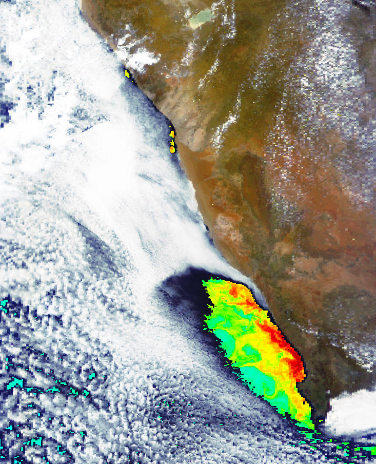
This (above) is a large upwelling off the west coast of south Africa.

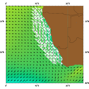
The Benguela Current ( above, highlighted in white) creates the upwelling shown in the first picture, off the coast of south west Africa.
Climate Zones
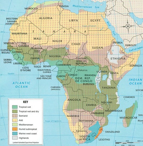
Using the Koppen classification system Africa has many climates. The most significant climate is the Sahara, which covers the northern third of the continent Africa, and about 30% of all arid lands in the world. Its classification is BWH which means arid, desert, and hot arid. The middle third of africa has an Equatorial climate. Right on the equator is Af which means equatorial and fully humid. Bordering the Af area is the Am which means monsoonal. The lower third of Africa has a warm temperate climate in the north of the bottom third, an arid climate with some desert, the eastern edge of the southernmost part of Africa has warm temperate, hot summer, and is fully humid. Over 50% of Africa has inadequate precipitation and 92% has climate climate contrasts, examples being where in one place there is a shortage of water, and in another there is an oversupply of it. Africa is completely surrounded by water, with the Atlantic Ocean to the west, The Mediterranean Sea to the north, and the Red Sea and the Indian Ocean to the east. Africa extends from about 38 degrees N latitude to 35 degrees S latitude. Cold ocean currents cause the south western tip of Africa to be dry.
Minerals of Africa
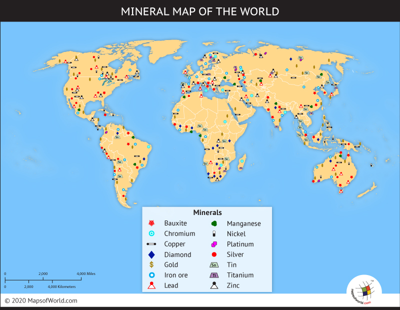
The minerals that are primarily found in Africa are uranium, lead, zinc, iron, diamond, bauxite, coal, copper,and gold. There is a very large span of regions across Africa where clumps of minerals are found. On the coastline of North-Western Africa, an abundant amount of iron can be found along with smaller portions of coal, lead, and zinc. On the Mid-Western area of the continent, bauxite and gold is found. The southern region of Africa is where the most minerals are mined such as uranium, iron, gold, diamonds, coal, copper, lead, and zinc. Africa is the world's richest resource of diamonds with roughly 49% originating from Central and Southern Africa alone (Figure 1). Generally, these diamonds are mined from pipes, which dive deep in the Earth where geological processes, as well as, high pressure and temperature enable the formation of the crystals. Throughout time, the diamonds are created and pushed up through the pipes and can eventually reach the surface.
Natural Resources Of African Countries
Algeria: petroleum, natural gas, iron ore, phosphates, uranium, lead, zinc, Angola: petroleum, diamonds, iron ore, phosphates, copper, feldspar, gold, bauxite, uranium, Benin: small offshore oil deposits, limestone, marble, timber, Botswana: diamonds, copper, nickel, salt, soda ash, potash, coal, iron ore, silver, Burkina: manganese, limestone, marble; small deposits of gold, phosphates, pumice, salt, Burundi: nickel, uranium, rare earth oxides, peat, cobalt, copper, platinum, vanadium, arable land, hydropower, niobium, tantalum, gold, tin, tungsten, kaolin, limestone, Cameroon: petroleum, bauxite, iron ore, timber, hydropower, Cape Verde: salt, basalt rock, limestone, kaolin, fish, clay, gypsum, Central African Republic: diamonds, uranium, timber, gold, oil, hydropower, Chad: petroleum, uranium, natron, kaolin, fish (Lake Chad), gold, limestone, sand and gravel, salt, Comoros: NEGL, Congo: petroleum, timber, potash, lead, zinc, uranium, copper, phosphates, gold, magnesium, natural gas, hydropower, Democratic Republic of Congo: cobalt, copper, niobium, tantalum, petroleum, industrial and gem diamonds, gold, silver, zinc, manganese, tin, uranium, coal, hydropower, timber, Djibouti: potential geothermal power, gold, clay, granite, limestone, marble, salt, diatomite, gypsum, pumice, petroleum, Egypt: petroleum, natural gas, iron ore, phosphates, manganese, limestone, gypsum, talc, asbestos, lead, rare earth elements, zinc, Equatorial Guinea: petroleum, natural gas, timber, gold, bauxite, diamonds, tantalum, sand and gravel, clay , Eritrea: gold, potash, zinc, copper, salt, possibly oil and natural gas, fish, Ethiopia: small reserves of gold, platinum, copper, potash, natural gas, hydropower, Gabon: petroleum, natural gas, diamond, niobium, manganese, uranium, gold, timber, iron ore, hydropower, Gambia: fish, clay, silica sand, titanium (rutile and ilmenite), tin, zircon, Ghana: gold, timber, industrial diamonds, bauxite, manganese, fish, rubber, hydropower, petroleum, silver, salt, limestone, Guinea, Guinea-Bissau: fish, timber, phosphates, bauxite, clay, granite, limestone, unexploited deposits of petroleum, Kenya: limestone, soda ash, salt, gemstones, fluorspar, zinc, diatomite, gypsum, wildlife, hydropower, Lesotho: water, agricultural and grazing land, diamonds, sand, clay, building stone, Liberia: iron ore, timber, diamonds, gold, hydropower, Libya: petroleum, natural gas, gypsum, Madagascar: graphite, chromite, coal, bauxite, rare earth elements, salt, quartz, tar sands, semiprecious stones, mica, fish, hydropower, Malawi: limestone, arable land, hydropower, unexploited deposits of uranium, coal, and bauxite, Mali: gold, phosphates, kaolin, salt, limestone, uranium, gypsum, granite, hydropower (note: bauxite, iron ore, manganese, tin, and copper deposits are known but not exploited), Mauritania: iron ore, gypsum, copper, phosphate, diamonds, gold, oil, fish, Mauritius: arable land, fish, Morocco: phosphates, iron ore, manganese, lead, zinc, fish, salt, Mozambique: coal, titanium, natural gas, hydropower, tantalum, graphite, Namibia: diamonds, copper, uranium, gold, silver, lead, tin, lithium, cadmium, tungsten, zinc, salt, hydropower, fish (note: suspected deposits of oil, coal, and iron ore), Niger: uranium, coal, iron ore, tin, phosphates, gold, molybdenum, gypsum, salt, petroleum , Nigeria: natural gas, petroleum, tin, iron ore, coal, limestone, niobium, lead, zinc, arable land, Rwanda: gold, cassiterite (tin ore), wolframite (tungsten ore), methane, hydropower, arable land, Sao Tome and Principe: fish, hydropower, Senegal: fish, phosphates, iron ore, Seychelles: fish, copra, cinnamon trees, Sierra Leone: diamonds, titanium ore, bauxite, iron ore, gold, chromite, Somalia: uranium and largely unexploited reserves of iron ore, tin, gypsum, bauxite, copper, salt, natural gas, likely oil reserves, South Africa: gold, chromium, antimony, coal, iron ore, manganese, nickel, phosphates, tin, rare earth elements, uranium, gem diamonds, platinum, copper, vanadium, salt, natural gas, South Sudan: hydropower, fertile agricultural land, gold, diamonds, petroleum, hardwoods, limestone, iron ore, copper, chromium ore, zinc, tungsten, mica, silver, Sudan: petroleum; small reserves of iron ore, copper, chromium ore, zinc, tungsten, mica, silver, gold; hydropower, Swaziland: asbestos, coal, clay, cassiterite, hydropower, forests, small gold and diamond deposits, quarry stone, and talc, Tanzania: hydropower, tin, phosphates, iron ore, coal, diamonds, gemstones, gold, natural gas, nickel, Togo: phosphates, limestone, marble, arable land, Tunisia: petroleum, phosphates, iron ore, lead, zinc, salt, Uganda: copper, cobalt, hydropower, limestone, salt, arable land, gold, Zambia: copper, cobalt, zinc, lead, coal, emeralds, gold, silver, uranium, hydropower, Zimbabwe: coal, chromium ore, asbestos, gold, nickel, copper, iron ore, vanadium, lithium, tin, platinum group metals
Tectonic Plates
Africa is a very technically active region. It is on the African Plate and has almost no active margins. All of Africa's plates divergent so not many earthquakes nor volcanoes form on the boundaries. The latest strong earthquake was a 7.5 that happened in Mozambique. While most active African volcanoes along the east african rift valey.
Bibliography
- [2]
- [4]
- [3]
- http://library.thinkquest.org/16645/the_land/congo_river.shtml
- http://www.ancient-egypt-online.com/river-nile-facts.html
- http://www.victoriafalls-guide.net/zambezi-river.html
- http://www.cichlid-forum.com/articles/lakes_east_africa.php
- http://goafrica.about.com/od/africatraveltips/ig/Maps-of-Africa/Topographical-Map-of-Africa.htm
- Google Earth
- http://library.thinkquest.org/16645/the_land/atlas_mountains.shtml
- http://www.britannica.com/EBchecked/topic/170953/Drakensberg
- http://koeppen-geiger.vu-wien.ac.at/present.htm
- https://www.courses.psu.edu/test/test100_hkr/AFIM/Main_HTML/M_CL.html
- http://www.flickr.com/photos/48216873@N03/4418490326/
- http://www-das.uwyo.edu/~geerts/cwx/notes/chap11/safrica.html
- http://oceancurrents.rsmas.miami.edu/atlantic/benguela.html
- https://www.cia.gov/library/publications/the-world-factbook/fields/2111.html
- http://geology.er.usgs.gov/eespteam/diamondproject/