Earth Science 7-Australia2
Earth Science 7-Global Regions Index
Contents
Countries
The countries in our region are Fiji, New Zealand, Antarctica, and Australia.
Elevation Range
Our region's lowest point is the Lake Erie, -15 m. It's highest point is the Vinson Massif, 4,897 m. [https://www.cia.gov/library/publications/the-world-factbook/geos/ay.html ]
Latitude and Longitude Range
Our region extends from South 16 degrees to south 90 degrees, and 179 degrees west to 113 degrees east.
Bordering Oceans
Our region's bordering oceans are the Pacific, Indian, and the Southern Ocean.
Large Bodies of Water
Our region's main bodies of water are Lake Raeside, Lake Carnegie, Lake Mackay, Lake Barlee, Lake Torrens, Lake Gairdner, and Lake Erye.
Topographic Features
The Ronne-Filchner Ice Shelf, the Ross Ice Shelf, the Australian Alps, the Gregory Range, Blue Mountains, the Simpson Desert, the Flinders Ranges, Strzelecki Desert, the Great Sandy Desert, the Gibson Desert, the Tanami Desert, the Olgas mountain range, and Mt. Kosciusko are all topographic features of our region.
Climate
Our region's climates are polar, warm temperate, equatorial, and arid. Part of our region is located on the poles, causing it to have a polar climate. Also, part of our region is in the middle latitudes, causing it to have warm climate. Also, part of our region is in a desert, causing it to have an arid climate. And part of our region is located near the equator, causing it to have a equatorial climate. There are many ocean currents that affect our region like the Eastern Australian Current (EAC), the Western Australian Current, and the Southern Equatorial Current. The warmer the currents the more evaporation there is, and the more water in the air, the more chance of rain there is. The opposite occurs with colder currents.
Currents
The currents around Australia are the East Australian Current, the Southern Equatorial Current,the Leeuwin Current, and the Western Australian Current. The only current around Antarctica is the Antarctic Circumpolar Current. Since the poles have the coldest waters, the waters are the most dense in the world and sink to the bottom of the ocean, causing Antarctica to have density currents and not surface currents.
Ice Cover
The majority of ice cover in our region is in Antarctica, which is covered completely and also composed of ice. The ice cover in Antarctica is always there and never goes away. However, the ice cover in our region is slowly shrinking due to global warming.
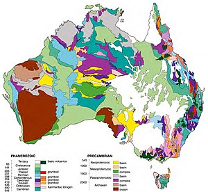
Rocks and Mineral Wealth
In Australia, there are more black coal reserves than any other element or mineral in the region. Australia also has many other elements and minerals such as copper, chromium, diamond, gold, cadmium, uranium, and vanadium. Gold in Australia usually comes from Western, Southern, and New South Wales, Australia. Bauxite, coal, iron, tungsten, and manganese are found in bedrock deposits offshore. Australia is the world's largest net exporter of coal. Almost all of the iron is found in northwestern Australia. One of the trends about where minerals are mined in Australia is that almost no mines are in the center of Australia and they are all on the shore or near the shore, if not offshore.
Tectonic Plates
In our region, there are the Antarctic Plate and the Australia Plate. The Antarctic Plate has divergent boundaries and the Australian Plate has deivergent, convergent, and transform boundaries. Antarctica has a passive margin, Australia has a passive margin, New Zealand has an active margin, and Fiji has a passive margin.
Volcanoes
Our region has many volcanoes, especially on the Australian Plate. The volcanoes our located in many different places. The volcanoes on the Antarctic plate are located towards the center of the Antarctic plate, but there are only a few volcanoes on the Antarctic plate boundary. Many of the volcanoes in the Australian Plate are on the plate boundary. Almost all of the volcanoes on the boundary are on the northern and eastern sides of the plate boundary. None of the volcanoes are on the southern and western sides of the plate boundaries. On the upper part of the eastern boundary of the Australian Plate, there is a chain of volcanoes that includes Fonualei, and Late. Most of the volcanoes in this region are either stratovolcanoes or submarine volcanoes. A couple of the strato volcanoes are Late and Fonualei, located in the tonga islands. Both of these strato volcanoes are basaltic-andesitic to andesitic magma composition, also known as dacitic magma composition. A couple of submarine volcanoes are Falcon Island and Metis Shoal, both located in the tonga islands. There is also a chain of volcanoes located on New Zealand. This chain of volcanoes contains calderas, complex volcanoes, and strato volcanoes. One of the Strato volcanoes is Egmont, located on the North Island of New Zealand. One of the calderas is Rotorua, also located on the North Island of New Zealand. The strato volcanoes in this chain of volcanoes have an andesitic magma composition and the complex volcanoes have a dacitic-andesitic magma composition. One of the volcanoes that has erupted recently with historical significance is Falcon Island. Since the 19th century, this volcano has had two island forming eruptions.
Earthquakes
There have been many earthquakes in our region. Most of the earthquakes have occurred on the Australian and Antarctic plate boundaries, and since Antarctica, Australia, and Fiji have passive margins, not many have occurred on land. Since New Zealand has an active margin, most of the earthquakes around that area have occurred in New Zealand. The most recent earthquake in Australia was in 1997. It had a magnitude of 6.6. The largest one there occurred in 1988 with a magnitude of 6.9. There hasn't been any earthquakes in the past 20 years in Antarctica. The most recent earthquakes in New Zealand were in 2003. There was one with a 7.5 magnitude, and one with a 6.4 magnitude. No earthquakes have occurred in Fiji in the last 20 years.
References
http://www.worldatlas.com/webimage/countrys/an.htm http://lrs.ed.uiuc.edu/students/downey/project/topography.html http://koeppen-geiger.vu-wien.ac.at/present.htm http://www.dpi.nsw.gov.au/__data/assets/pdf_file/0009/137286/ocean-currents-affect-climate.pdf http://www.australianminesatlas.gov.au/aimr/index.html Dynamic_Earth.kmz