Earth Science 7-Central America3
Earth Science 7-Global Regions Index
Contents
Central America

Earth Science 7-Global Regions Index http://www.google.com/imgres?q=Central+American&um=1&hl=en&client=safari&rls=en&biw=1024&bih=599&tbm=isch&tbnid=TJ0DWduLO4muxM:&imgrefurl=http://nearshoreamericas.com/regional-alliance-lift-central-america-investment/&docid=n5l51KlAZMQqyM&imgurl=
Central America is an isthmus that unites the two continents of North and South America.
a
Countries
Belize, Costa Rica, El Salvador, Guatemala, Panama, Nicaragua, Honduras, Puerto Rico, Bahamas, Haiti, Dominican Republic, Cayman Islands, Antilles, Cuba, Jamaica, Turks & Caicos
Oceans
Central America's bordering oceans are the Pacific Ocean and the Atlantic Ocean. It is also bordered by the Caribbean Sea.
--> salinity

The salinity of the waters on the left side of central America, The pacific ocean, is low. However, in the center of the left side, the salinity level is average. On the right side of central America, The Caribbean sea and the Atlantic ocean, It is more salty than in the pacific ocean. All the water ranges from average to upper average salinity.

Latitude and Longitude Ranges
32o16'13.26"N to about 25o51'38.18"N, 6o47'05.89"N to about 3o59'46.25"N,
116o58'56.49"W to about 96o54'45.68"W, 77o31'14.99"W to about 110o02'39.83"W
Land Features
Important Mountainous Areas
Tajulmuco is the highest peak in Central America, located in Guatemala, Sierra Madre in Guatemala, Mapa Mountains in Belize, Montanas de Comapagua of Honduras, Cordillera Isabelia of Nicaragua, Cordillera Talamanca of Costa Rica, Cordillera Central in Panama
major topographic features
The region is active with volcanoes and earthquakes. It is as well very mountainous. About four fifths of the region is either hilly or mountainous. There is a very large stretch of volcanoes that stretch from Guatemala to costa rica. Half the volcanoes in central America are dormant and about one fourth are extinct. The remaining, active volcanoes make up the largest volcanic region in the Americas.
Elevation Ranges
The highest point in Central America is Volcán Tajumulco in Guatemala which is an extinct volcano and is 13,845 feet (4,220 m) high. The lowest point in Central America is the Pacific Ocean at 0 m high.
ocean currents
the currents that surround Central America are the California, Florida, and North Equitorial currents. The California current flows down from califoria and the florida and north equitorial currents flow up on the right side.
Bodies of Water
Lago de Nicaragua, Lago de Atitlán, Lake Izabal, Lake Petén Itzá, Lake Amatitlán, Laguna Chicabal, Lago de Coatepeque (Coatepeque Lake), Lago De Ilopango (Ilopango Lake), Laguna De Güija (Güija Lake), Laguna Verde, Laguna de Alegria, Olomega Lake, Suchitlan Lake, Represa El Cajón, Lake Yojoa, Lake Apanás, Lake Nicaragua (Lake Cocibolca), Lake Managua, Lempa River, Motagua River, Usumacinta River, Patuca River, Ulua River, Chamelecon River, Aguan River, Humuya River, Choluteca River, Lean River, Coco River, Blanco River, Lempa River, Motagua River, Coco River, Escondido River, Grande de Matagalpa River, San Juan River, Gulf of Honduras, Gulf of Panama, Gulf of Fonseca, Gulf of Mexico, Gulf of Nicoya
Climate Zones
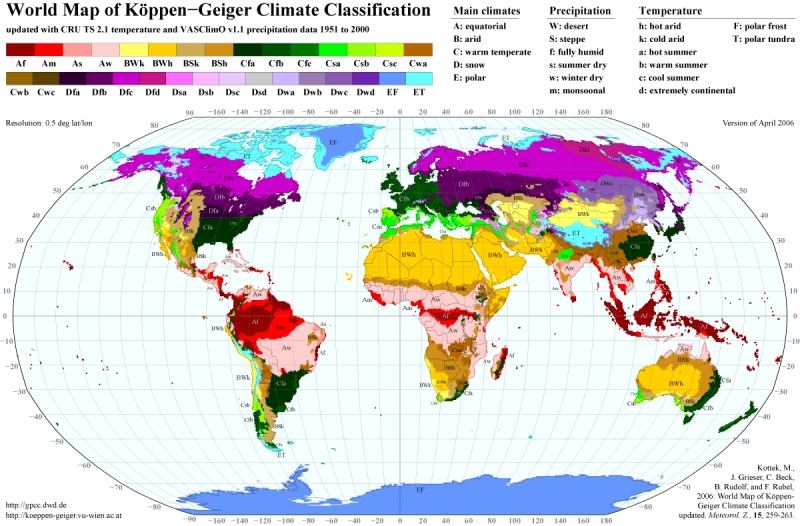
The main climate zones in Central America are Af, Am, As, and Aw. The lines of latitude of Central America are very close to the equator, which is what the capital A stands for at the beginning of each climate zone. Because of this the temperatures are very hot. Also, because central America is hot, the waters around it are hot. This also adds to Central America's humid climate.Each climate zone in Central America is afected by different factors in the atmoshpere. For example, the Aw region, equatorial winter dry, is battered with sea breezes with cool the atmoshpere around it. The Af region, equatorial fully humid, havelots of rainfall which provides almost 100% humidity. The Am region, equatorial monsoonal, is battered by seasonal winds whcih provide a little cooling so that it is not Af.
Minerals
Honduras: Gold, lead, zinc, silver, iron. Belize: Gold, Silica. Nicaragua: Gold, Gypsum, Hydraulic, cement, silver. Panama: Gold, Hydrolic, Cement. Costa Rica: Diatomite, Gold, Hydraulic, Cement. El Salvador: Gypsum, Hydrolic, Cement. Guatemals: Antimony, Barite, Bentonite, Feldspar, Gold, Gypsum, Hydraulic cement, silica, iron, kaolin, lead, magnesite, silver, talc, zinc. All of Central America's countries contain traces of gold. Many contain other minerals such as hydrolic cement and silver.
In the mountainous areas of Central America there is a large abundance of basalt and certain varieties of feldspar. Other rocks commonly found around that area are augite and olivine phenocrysts. Near the base of the mountains you will also find augite,olivine, and andesine.
Tectonic Plates
Central America is on the North America Plate and is surrounded by the Cocos, Caribbean, Rivera, and Panama Plates.
      Cocos Plate - subduction zone
      Caribbean Plate - Oceanic Convergent boundary, continental rift boundary
      Rivera Plate - Subduction zone, oceanic convergent boundary
      Panama Plate - Oceanic spreading ridge, oceanic transform fault, Oceanic convergent boundary, continental transform fault
      North America Plate - oceanic transform fault, oceanic spreading ridge, continental transform boundary
Rock Type
Margin Types
Earthquakes
Many earthquakes occur in Central America. Most tend to occur on the west coast of Central America. The west coast is right on a tectonic plate boundary. There have been numerous Earthquakes that have happened on the coast very recently and they all seem to be spread out. There are no clumps of earthquakes in a particular place. These earthquakes mainly have a magnitude of between 1 and 4.
Volcanoes
Cordillera de Talamanca is a mountain range that lies across the Central American countries of Costa Rica and Panama. The Cordillera de Talamanca is made up of almost all volcanoes, containing more than 20 active volcanoes. Most volcanoes in this mountain range erupt basaltic-andesitic lava.
The region of upper Mexico, near the border with California, contains Tuff cone and Stratovolcanoe, volcanoes. These tend to be rhyolitic and are currently in the fumaralic state.
There have been no recent volcanic eruptions in Central America according to [1].
Refrences
http://www.encyclopedia.com/topic/Central_America.aspx
http://www.newworldencyclopedia.org/entry/Central_America
http://koeppen-geiger.vu-wien.ac.at/present.htm
http://rs-nautical.blogspot.com/2011/04/sea-salinity.html
http://minerals.usgs.gov/minerals/pubs/country/latin.html
http://www.indexmundi.com/minerals/?country=bz&graph=production
http://www.volcano.si.edu/world/region.cfm?rnum=1401
Cite error: <ref> tags exist, but no <references/> tag was found