Earth Science 7-Europe/Iceland 1
Contents
- 1 Links
- 2 Region Name
- 3 Countries
- 4 Latitude and Longitude
- 5 Elevation Range
- 6 Large Bodies of Water, Rivers
- 7 Major Topographic Features
- 8 Bordering Oceans
- 9 Climate Zone
- 10 Average Monthly Temperature high/low (in Centigrade)
- 11 Average Precipitation
- 12 Factors that Affect the Climate
- 13 Geology
- 14 Tectonic Plates
- 15 References
Links
Region Name
Europe and Iceland
Countries
- Iceland
- England
- France
- Italy
- Spain
- Hungary
- Portugal
- Norway
- Holland
- Sweden
- Finland
- Switzerland
- Austria
- Ukraine
- Belgium
- Lithuania
- Romania
- Macedonia
- Turkey
- Greece
- Denmark
- Moldova
- Monaco
- Poland
- Ireland
- Bulgaria
- Slovenia
- Croatia
- Bosnia- Herzegovina
- San Marino
- Serbia
- Luxembourg
- Belarus
- Mont.
- United Kingdon
- Germany
- Latvia
- Czech Republic
- Kosovo
- Andorra
- Slovakia
- Estonia
- Montenegro
- Malta
- Vatican City
- Liechtenstein
- Albania
Latitude and Longitude
Europe- 48° 41' 27" N / 9° 8' 26" E
Iceland- 65° 0' 0" N / 18° 0' 0" W
Elevation Range
Europe- Mt. Elbrus= 18,510 ft. (5,642 m) Caspian Sea= 92 ft. below sea level (–28 m)
Iceland- Atlantic Ocean= 0 m Hvannadalshnukur= 2,119 m
Large Bodies of Water, Rivers
Bodies of Water-
- Caspian Sea
- Mediterranean Sea
- Black Sea
- White Sea
- Baltic Sea
- Sea of Azov
- English Channel
- Norwegian Sea
- Bay of Biscay
- Huna Bay
- Denmark Strait
- Bierdha Fjord
- Faza Bay
- Aegean Sea
Rivers-
- Danube
- Dnieper
- Don
- Elbe
- Loire
- Oder
- Po
- Rhine
- Rhone
- Shannon
- Tagus
Major Topographic Features
Europe-
- Alps
- Apennines
- Atlantic Highlands
- Balkan Mountains
- Carpathian Mountains
- Caucasus Mountains
- Great Hungarian Plains
- Kjolen Mountains
- Massif Central
- Mesata
- North European Plains
- Pyrenees
- Scandinavian Shield
Iceland-
- Drangajokull Glacier
- Langjokull Glacier
- Hofsjokull Glacier
- Vatnajokull Glacier
- Myrdalsjokull Glacier
- Eyjafjallajokull Glacier
- Oraefajokull Mountains
Bordering Oceans
Europe- Atlantic Ocean and Arctic Ocean
Iceland- Arctic Ocean and Atlantic Ocean
Climate Zone
Cfb(Marine West Coast) on the Köppen Climate Chart [11]
Average Monthly Temperature high/low (in Centigrade)
| England Temperature | Jan | Feb | Mar | Apr | May | Jun | Jul | Aug | Sep | Oct | Nov | Dec | Annual | ||
| Avg. Temperature | 3.85 | 3.95 | 5.85 | 7.65 | 10.85 | 13.6 | 16.0 | 15.85 | 13.4 | 10.1 | 6.5 | 4.7 | 9.35 | ||
| Avg. Max Temperature | 6.6 | 6.9 | 9.3 | 11.7 | 15.4 | 18.1 | 20.6 | 20.5 | 17.5 | 13.6 | 9.5 | 7.4 | 13.1 | ||
| Avg. Min Temperature | 1.1 | 1.0 | 2.4 | 3.6 | 6.3 | 9.1 | 11.4 | 11.2 | 9.3 | 6.6 | 3.5 | 2.0 | 5.6 | ||
| Ireland Temperature | Jan | Feb | Mar | Apr | May | Jun | Jul | Aug | Sep | Oct | Nov | Dec | Annual | ||
| Avg. Temperature | 3.95 | 4.15 | 5.6 | 7.2 | 9.9 | 12.4 | 14.5 | 14.15 | 12.0 | 9.3 | 6.15 | 4.75 | 8.85 | ||
| Avg. Max Temperature | 6.7 | 7.1 | 8.9 | 11.1 | 14.2 | 16.5 | 18.4 | 18.1 | 15.7 | 12.5 | 9.2 | 7.5 | 12.2 | ||
| Avg. Min Temperature | 1.2 | 1.2 | 2.3 | 3.3 | 5.6 | 8.3 | 10.6 | 10.2 | 8.3 | 6.1 | 3.1 | 2.0 | 5.2 | ||
| Scotland Temperature | Jan | Feb | Mar | Apr | May | Jun | Jul | Aug | Sep | Oct | Nov | Dec | Annual | ||
| Avg. Temperature | 1.9 | 1.95 | 3.9 | 5.7 | 8.65 | 11.05 | 13.1 | 12.9 | 10.55 | 7.85 | 4.7 | 3.1 | 7.25 | ||
| Avg. Max Temperature | 5.0 | 5.2 | 6.9 | 9.3 | 12.8 | 14.9 | 16.9 | 16.6 | 13.9 | 10.8 | 7.4 | 5.7 | 10.5 | ||
| Avg. Min Temperature | -0.2 | -0.1 | 0.9 | 2.1 | 4.5 | 7.2 | 9.3 | 9.2 | 7.2 | 4.9 | 2.0 | 0.5 | 4.0 | ||
| Wales Temperature | Jan | Feb | Mar | Apr | May | Jun | Jul | Aug | Sep | Oct | Nov | Dec | Annual | ||
| Avg. Temperature | 3.9 | 3.85 | 5.5 | 7.2 | 10.25 | 12.7 | 15.0 | 14.75 | 12.5 | 9.65 | 6.5 | 4.8 | 8.9 | ||
| Avg. Max Temperature | 6.5 | 6.6 | 8.6 | 11.0 | 14.5 | 16.8 | 19.1 | 18.8 | 16.2 | 12.8 | 9.3 | 7.4 | 12.3 | ||
| Avg. Min Temperature | 1.3 | 1.1 | 2.4 | 3.4 | 6.0 | 8.6 | 10.9 | 10.7 | 8.8 | 6.5 | 3.7 | 2.2 | 5.5 | ||
Average Precipitation
| England Precipitation | Jan | Feb | Mar | Apr | May | Jun | Jul | Aug | Sep | Oct | Nov | Dec | Annual | ||
| Precipitation(mm) | 84.3 | 60.1 | 66.6 | 56.9 | 55.2 | 62.9 | 54.2 | 66.8 | 73.4 | 83.7 | 83.5 | 90.5 | 838.7 | ||
| Days with Precipitation Less Than One mm | 13.4 | 10.4 | 12.1 | 10.1 | 9.8 | 9.8 | 8.5 | 9.4 | 10.2 | 11.8 | 12.5 | 13.1 | 131.2 | ||
| Ireland Precipitation | Jan | Feb | Mar | Apr | May | Jun | Jul | Aug | Sep | Oct | Nov | Dec | Annual | ||
| Precipitation(mm) | 119.1 | 86.6 | 93.5 | 70.6 | 68.1 | 72.1 | 73.3 | 90.9 | 94.5 | 114.6 | 110.6 | 118.5 | 1112.4 | ||
| Days with Precipitation Less Than One mm | 17.8 | 14.1 | 16.4 | 12.4 | 12.6 | 12.4 | 13.1 | 13.9 | 14.4 | 16.4 | 16.7 | 16.9 | 177.0 | ||
| Scotland Precipitation | Jan | Feb | Mar | Apr | May | Jun | Jul | Aug | Sep | Oct | Nov | Dec | Annual | ||
| Precipitation(mm) | 170.6 | 123.6 | 138.7 | 86.3 | 79.1 | 85.2 | 92.2 | 107.5 | 139.8 | 162.8 | 166.0 | 169.7 | 1521.4 | ||
| Days with Precipitation Less Than One mm | 18.6 | 14.8 | 17.3 | 13.0 | 12.2 | 12.7 | 13.3 | 14.1 | 15.9 | 17.7 | 17.9 | 18.2 | 185.8 | ||
| Wales Precipitation | Jan | Feb | Mar | Apr | May | Jun | Jul | Aug | Sep | Oct | Nov | Dec | Annual | ||
| Precipitation(mm) | 158.6 | 114.0 | 118.8 | 85.9 | 80.7 | 86.2 | 78.4 | 106.0 | 124.0 | 153.2 | 156.8 | 173.3 | 1435.9 | ||
| Days with Precipitation Less Than One mm | 17.4 | 13.4 | 15.1 | 11.7 | 11.5 | 11.4 | 10.3 | 12.2 | 13.0 | 15.8 | 16.7 | 17.1 | 165.5 | ||
Factors that Affect the Climate
Latitude Latitude affects the climate because when you go to a higher latitude, the tempeture drops, making the region colder than a region in a lower latitude.Europe is close to 60 degrees North latitude, in the mid-latitudes low pressure area.
Elevation, Proximity to Water, and Topography Elevation affects the climate because when you get into higher altitudes, the tempeture and the air pressure drops.The proximity to water affects the climate because when you are closer to water the temperature tends to be more steady and doesn't change as rapidly than a region not near to water. This occurs because water and land have different cooling and heating rates.Next to Mt. Elbrus, it would be colder and drier because it is at a higher elevation and has a lower air pressure. Next to the Caspian Sea, it would warmer and moister because it is next to a body of water. Since Europe is near the Mediterranean Sea, the temperature would be colder and it would be humid because it is near the poles.
Prevailing Winds Wind pushes warm or cold air into a region. It can also push storms or clear weather into a region.
Currents The North Atlantic Drift Current is an ocean current that transports warm waters to latitudes higher than any other ocean.
High and Low Pressure Systems The Alps is a major topographic feature that affects the climate and prevailing winds. It affects the prevailing winds by forcing the warmer air from the lower area into a higher area. It affects the climate because it is accompanied by precipitation.
Vegetation Vegetation would also affect the climate. In urban areas, there is often concrete, but vegetation absorbs less heat, so therefore vegetation makes the urban areas cooler.
Geology
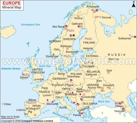
Minerals
Europe
Oil: Romania, Great Britain, and Ukraine
Coal: France, Spain, Germany, and Poland
Lead and Zinc: Spain, Poland, and Italy
Uranium: France
Bauxite: Hungary and Slovakia
Copper: Poland and Ukraine
Iron: Sweden and Finland
Silver: France
Rock Types
Europe
flysch: [flish] a sedimentary sequence consisting of marine deposits of dark, thinly bedded, fine-grained marls, sandstones, shales, clays, and muds.
Flysch: an extensive, late Cretaceous to Oligocene sedimentary formation bordering the Swiss Alps and associated with the Alpine orogeny.
Insubric line: boundary between the European and Adriatic plates.
marl: a calcerous clay or mixture of clay and particles of calcite and dolomite, usually derived from shell fragments.
massif: a large block of rock or other structural feature within an orogenic belt that is usually older and more rigid than the surrounding rocks.
molasse:
- a sedimentary sequence deposited during the Miocene period in southern Germany, subsequent to the rising of the Alps; composed primarily of soft, green sandstone associated with marl and conglomerates
- any similar sedimentary sequence
nappe: a large, sheetlike rock unit that has been transported some distance forward over other rocks, either by thrust faulting, recumbent folding, or both. (what would be called a thrust sheet in the Western U.S.)
The Alps: The Alpine chain of western Europe resulted from the subduction of Tethyan oceanic crust followed by a continent-continent collision between Africa and Europe. The mountain belt contains slices of sediment and continental crust scraped off of both the European and African margins, as well as ophiolites. These nappes are at most only a few kilometers thick each, but have produced pronounced crustal thickening as a whole. The Alpine orogeny was very complex and occurred in several phases from the middle Cretaceous to the Neogene, of which the collision between Europe and Africa was only one. Much of the earlier deformation has been overprinted in the Alps by the later mountain building in the Tertiary. [19]
Europe Geological Map

Iceland
Iceland lies on the geologic rift between the Eurasian plate and the North American plate. It also lies above a hotspot, the Iceland plume, which is believed to have caused the formation of Iceland itself. The result is an island of volcanism and geothermal phenomena such as geysers. The eruption of Laki in 1783 caused much devastation and loss of life and affected Europe. In the period 1963 to 1967 the new island of Surtsey was created on the southwest coast by a volcanic eruption. [21]
- Gabbro
- Dolerite
- Diorite
- Rhyolite
- Granophyre
- Granite
Iceland Geological Map


Mining Resources
Europe
- Copper
- Gold
- Iron and Steel
- Iron Ore
- Lead and Zinc
- Nickel
- Platinum- Group Metals
- Diamond
- Phosphate Rock
- Potash
- Coal
- Natural Gas
- Petroleum
- Uranium
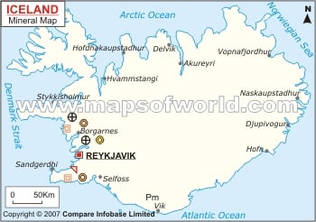
Iceland
- Aluminum
- Diatomite
- Pumice
- Scoria
- Salt
- Sand
- Basalt
- Rhyolite
Tectonic Plates
Plates:
Europe: Eurasian Plate
Iceland: North American Plate and Eurasian Plate
Boundaries:
Europe: Divergent Boundary on the west side and Convergent Boundary on the south side
Iceland: Divergent Boundary right in the middle
Active or Passive Margins:
Europe: Passive Margin- on the northwest side, it is a divergent boundary in the middle of the Atlantic Ocean
Active Margin- on the south side, it is the convergent boundary between the Eurasian Plate and the Arabian Plate
Iceland: Active Margin- right in the middle there is a divergent boundary, it is also the place where the Mid-Ocean Ridge rises above the surface
Volcanoes
Europe:
Germany:
- Vogtland volcanic area
- Laacher See
- Kaisertuhl
Armenia:
- Aragats
- Ghegam
- Porak
- Dar- Alages
- Tskhouk
- Karckar
Italy:
- Eolian Islands, Stromboli
- Lipari
- Volcano Amiata
- Vulsini
- Monte Albano
- Campi Flegrei (Phlegrean Fields)
- Vesuvius
- Ischia
- Etna
- Campi Flegrei Mar Sicilia
- Pantelleria
Turkey:
- Akyarlar
- Kenger
- Sandal
- Kula
- Karadag
- Karapinar
- Hasan Dagi
- Gollu Dag
- Acigol- Nevsehir
- Erciyes Dag
- Koruhuyugu
- Karaca Dag
- Nemrut Dag
- Suphan Dag
- Kars
- Girekol
- Tendurek Dag
- Ararat
Greece:
- Sousaki
- Methana
- Milos
- Nisyros
- Kolumbo
- Santorini
Portugal:
- Azores Corvo
- Flores
- Graciosa
- Terceira
- San Jorge
- Fayal
- Pico
- Sete Cidades
- Faja de Cima
- Agua de Pau
- Furnas
- Madeira Madeira
Spain:
- Canary Islands, Lanzarote
- Fuerteventure
- Gran Canaria
- Tenerife
- La Gomera
- La Palma
- El Hierro
- Olot Field
The earliest known documentation of volcanism is an Anatolian wall painting of a nearby cinder cone eruption around 6200 BC; the vigorous record of Etna goes back to 1500 BC; and the catastrophic eruption of Vesuvius in 79 AD, with the burial of Pompeii, continues to serve today as an object lesson in volcanism. The region has given us the first documented "new mountain," Monte Nuovo, in 1538, the first "new island" at Santorini, in 197 BC, and the word "volcano" itself.
[28]
Mount Vesuvius (composite volcano), towering over the Bay of Naples, is one of the most dangerously active volcanoes present today. The magma related to this volcano is andesitic magma. A close competitor is the Mount Etna (composite volcano), located on the coast of Sicily, near Messina and Catania. The magma related to this is andesitic magma.Mount Stromboli, in Stromboli, Italy is another active volcano in Italy. Stromboli is one of the eight Aeolian Islands, a volcanic arc north of Sicily. It is a shield volcano associated with basaltic magma.[29][27]
Iceland:
- Theistareykjarbunga- basaltic magma
- Krafla- basaltic magma
- Fremrinamur- basaltic magma
- Askja- andesitic magma
- Lysuhóll- rhyolitic magma
- Ljósufjöll- basaltic magma
- Snaefellsjökull- andesitic magma
- Hofsjökull- basaltic magma
- Langjökull- andesitic magma
- Tungnafellsjökull- andesitic magma
- Kverkfjöll- andesitic magma
- Kerlingarfjöll- andesitic magma
- Bárdarbunga- andesitic magma
- Prestahnukur- basaltic magma
- Loki-Fögrufjöll- rhyolitic magma
- Grímsvötn- rhyolitic magma
- Esjufjöll- andesitic magma
- Hengill- basaltic magma
- Grímsnes- basaltic magma
- Öraefajökull- andesitic magma
- Torfajökull- andesitic magma
- Krísuvík- basaltic magma
- Brennisteinsfjöll- basaltic magma
- Vatnafjöll- basaltic magma
- Reykjanes- rhyolitic magma
- Tindfjallajökull- rhyolitic magma
- Katla- basaltic magma
- Eyafjallajökull- andesitic magma
- Vestmannaeyjar- andesitic magma
Mount Hekla(composite) is an active volcano in Southern Iceland. It is associated with andesitic magma.
Iceland has many volcanoes due to a large volcanic hot spot sitting on a mid- ocean ridge [30]
Earthquakes
Europe:
Europe has many earthquakes. The Earthquakes tend to occur around Greece, Spain and Italy. There are fault lines near, which contribute to the earthquakes. Only 33 earthquakes exceeded the magnitude of 5.0 between 1981 and 2002, and the largest event is the 1997, September 26, Umbria-Marche earthquake. On April 6, 2009, an earthquake of 6.2 magnitude shook central Italy, killing 299 people. September 7, 1999, an earthquake of 6.0 magnitude shook Athens, Greece, killing 143 people. May 11, 2011, two earthquakes of 4.4 and 5.2 magnitudes shook Murcia, Spain, killing 10 people. Significant earthquakes include the 1755 Lisbon earthquake, Portugal earthquake on November 1,1755. Seismologists today estimate that the Lisbon earthquake had a magnitude in the range 8.5–9.0 on the moment magnitude scale. Estimates place the death toll in Lisbon alone between 10,000 and 100,000 people, making it one of the deadliest earthquakes in history. On December 28, 1908 from about 05:20 to 05:21 an earthquake of 7.2 on the magnitude scale occurred centered on the city of Messina, Sicily. The ground shook for 30 to 40 seconds, and the destruction was felt within a 300 km radius. Moments after the earthquake, a 12 m tsunami struck nearby coasts causing even more devastation.
.gif)
References
- ↑ http://www.worldbookonline.com/advanced/extmedia?id=ar186660&st=europe&em=mp000070
- ↑ http://www.travelmath.com/continent/Europe
- ↑ http://www.travelmath.com/country/Iceland
- ↑ http://www.infoplease.com/ipa/A0001763.html
- ↑ http://www.worldatlas.com/aatlas/infopage/highlow.htm
- ↑ http://www.worldatlas.com/webimage/countrys/eu.htm
- ↑ http://www.worldatlas.com/webimage/countrys/euriv3.htm
- ↑ http://www.worldatlas.com/webimage/countrys/europe/is.htm
- ↑ http://www.worldatlas.com/webimage/countrys/euland4.htm
- ↑ http://www.worldatlas.com/webimage/countrys/europe/lgcolor/iscolor.htm
- ↑ http://www.srh.noaa.gov/jetstream/global/climate_max.htm
- ↑ http://www.metoffice.gov.uk/climate/uk/averages/19712000/areal/england.html
- ↑ http://www.metoffice.gov.uk/climate/uk/averages/19712000/areal/n_ireland.html
- ↑ http://www.metoffice.gov.uk/climate/uk/averages/19712000/areal/scotland.html
- ↑ http://www.metoffice.gov.uk/climate/uk/averages/19712000/areal/wales.html
- ↑ http://oceancurrents.rsmas.miami.edu/atlantic/north-atlantic-drift.html
- ↑ http://www.mapsofworld.com/world-mineral-map.htm
- ↑ http://www.mapsofworld.com/iceland/iceland-mineral-map.html
- ↑ http://www.geo.arizona.edu/geo5xx/geo527/Alps/geology.html
- ↑ http://en.wikipedia.org/wiki/Geology_of_Europe
- ↑ http://en.wikipedia.org/wiki/Geology_of_Iceland#External_links
- ↑ https://notendur.hi.is/oi/iceland_excursion.htm
- ↑ http://en.wikipedia.org/wiki/Geology_of_Iceland#External_links
- ↑ https://notendur.hi.is/oi/iceland_excursion.htm
- ↑ http://minerals.usgs.gov/minerals/pubs/country/2007/myb3-sum-2007-europe-eurasia.pdf
- ↑ http://minerals.usgs.gov/minerals/pubs/country/2007/myb3-2007-ic.pdf
- ↑ 27.0 27.1 Perry's Handbook, Sixth Edition, McGraw- Hill Co., 1984.
- ↑ http://www.volcanodiscovery.com/europe.html
- ↑ http://www.buzzle.com/articles/active-volcanoes-in-europe.html
- ↑ http://www.volcanodiscovery.com/iceland.html
- ↑ http://news.xinhuanet.com/english2010/world/2010-02/28/c_13191133.htm
- ↑ http://en.wikipedia.org/wiki/1999_Athens_earthquake
- ↑ http://www.bbc.co.uk/news/world-europe-13368599
- ↑ http://en.wikipedia.org/wiki/1755_Lisbon_earthquake
- ↑ http://en.wikipedia.org/wiki/1908_Messina_earthquake
- ↑ https://www.e-education.psu.edu/earth501/content/p2_p4.html