Earth Science 7-North America2
Earth Science 7-Global Regions Index
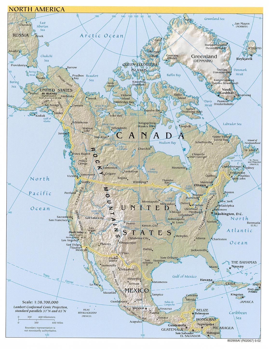
This map shows the elevation, mountains, rivers, lakes, cities, and countries of North America.
Contents
Countries
United States of America, Mexico, Greenland, and Canada.
Latitude and Longitude
Latitude is 173 degrees 25' 43.31W to 51 degrees 57' 53.59"W.
Longitude is 83 degrees 42' 39.32"N to 14 degrees 24'23.26"N.
Elevation Range
The highest elevation in thee United States is Mount McKinley which is in Denali, Alaska. It is located in the Alaska Range mountain range. It is 20,320 ft./6,149 m high. Mt. McKinley is 20,174 ft./7,450km/4,629mi. Also, this mountain is located 63.0690°N 151.0063°W.
The lowest elevation in the United States is Death Valley which is in California. It is located in the Mojave Desert. It is 86m below sea level! Death Valley holds the record for the highest recorded temperature in the western hemisphere which is 134 degrees F. This temperature was recorded at Furnace Creek on July 10, 1913. It runs from north to south between the Amargosa Range on the east, the Panamint Range on the west, the Sylvania Mountains, and the Owlshead Moutains form its northern and southern boundaries.
Bodies of Water
Major Lakes:
Lake Huron-MI,
Lake Ontario-MI,
Lake Michigan-MI,
Lake Erie-MI,
Lake Superior-MI,
and Salt Lake-UT.
Rivers
1. Missouri, 4087.733 km (flows into Mississippi River)
2. Mississippi, 3765.864 km (flows into Gulf of Mexico)
3. Yukon, 3186.501 km (flows into Bering Sea)
4. Rio Grande, 3057.573 km (flows into Gulf of Mexico)
5. St. Lawrence, 3057.573 km (flows into Gulf of St. Lawrence)
6. Arkansas, 2349.642 km (flows into Mississippi River)
7. Colorado, 2333.548 km (flows into Gulf of California)
8. Red, 2076.053 km (flows into Mississippi River)
9. Brazos, 2059.960 km (flows into Gulf of Mexico)
10. Columbia, 1995.586 km (flows into Pacific Ocean)
11. Snake, 1673.717 km (flows into Columbia River)
12. Platte, 1593.250 km (flows into Missouri River)
13. Ohio, 1578.766 km (flows into Mississippi River)
14. Pecos, 1490.252 km (flows into Gulf of Mexico)
15. Canadian, 1458.065 km (flows into Arkansas River)
16. Tennessee, 1425.878 km (flows into Ohio River)
17. Colorado, 1387.252 km (flows into Matagordo Bay)
18. North Canadian, 1287.475 km (flows into Canadian River)
19. Mobile, 1245.632 km (flows into Gulf of Mexico)
20. Kansas, 1195.742 km (flows into Missouri River)
21. Green, 1174.821 km (flows into Colorado River)
22. Kuskokwim, 1165.165 km (flows into Bering Sea)
23. James, 1142.643 km (flows into Missouri River)
24. Yellowstone, 1113.666 km (flows into Missouri River)
25. Tanana, 1060.557 km (flows into Yukon River)
26. Gila, 1013.886 km (flows into Colorado River)
27. Milk, 1005.84 km (flows into Missouri River)
28. Quachita, 973.653 km (flows into Red River)
Topographic Features
Alaska Range
Appalachian Mountains
Brooks Range
Canadian Shield
Cascades
Coast Range
Coastal Plain
Continental Divide
Great Plains
Rocky Mountains
Sierra Madres
Sierra Nevada
Oceans
Atlantic Ocean
Pacific Ocean
Arctic Ocean
Gulf of Mexico
Hudson Bay
Salinity
Atlantic Ocean ranges from 35 to 37.5
Pacific Ocean ranges from 33 to 36.5
Arctic Ocean ranges from 33 to 34
Gulf of Mexico ranges from 35.5 to 36
Hudson Bay ranges from 33 to 33.5
Currents
Cool currents on the west coast, and warm currants on the East coast. The there is Alaska and California currents. Great lakes have a very dry climate. Nino, Nina.
Selenity of Oceans
Climate
Climate Controls
Latitude- See Latitide and Longitude
Elevatiton- See elevation
Nearby Waters- See oceans and rivers
Ocean Currents- See oceans and rivers
Climate Types
Deciduous forest - Four distinct seasons with warm summers and cold, wet winters. The trees shed their leaves in autumn. These can be found in the southeast of North America because they have a denser region with more rain. (Untied States; New England, south of Florida, and from the Atlantic coast to the west of the Mississippi River)
Coniferous forest - Also known as Taiga, cold and dry with snowy winters and warmer summers. These grow in the lower latitudes of North America. (United States; Pacific, Northern, Southern, Central, Rockie Mountains, Coniferous forest regions)
Mediterranean - Warm to high temperatures with rainfall in the autumn and winter months. (United States; Much of California)
Grassland - Hot summers and cold winters with above average rainfall. (United Sates; From Texas to North Dakota, Indiana to Arizona, with some in Ohio, Canada; southern Canada
Tundra - This area is characterized by a layer of permafrost (soil that has remained below freezing for at least two years. Winters are very cold, summers are warm and there is little rainfall.
Alpine/mountain - Cold, windy and snowy. It is winter from October to May with temperatures below freezing, while summer is from June to September where the temperature can reach 15°C.
Rainforest - High temperatures and high rainfall throughout the year.
Desert - Warm to high temperatures with very little rainfall.
Koeppen Classification
Greenland-Polar
Canada-Cold, dry, and a tad bit of polar region
United States of America:
-Northwest: Polar
-North: Dry, Temperate, and Cold
-Northeast: Cold and Polar
-East: Cold and Temperate
-Southeast: Temperate
-South: Dry
-Southwest: Dry
-West: Temperate and Dry
Minerals/Rock Types
-The United States-
Coal mines: found in the middle of the country
Oil: found in southern California, Texas, and Northern Alaska
Silver mines: found in the north west
Iron mines: found Minnesota, Wisconsin, and the east coast
Copper mines: mainly found in eastern California
Gold mines: found in Alaska, and some parts of California
-Mexico-
Silver mines: found in central Mexico
Iron mines: found in western/central Mexico
Copper mines: found in northern Mexico
-Canada-
Uranium Mines: found in central Canada
Silver mines: found in southeastern Canada
Oil: found in southwestern Canada
Lead and Zinc mines: found in western and central Canada
Iron mines: found in central and eastern Canada
Coal mines: found in southern Canada
Copper mines: found in western and central Canada
Gold mines: found in southeastern Canada
Plate Tectonics
Plates: North America Plate, Juan de Fuca Plate, Pacific Plate, Cocos Plate
Boundary Types:
North America Plate- Divergent, Convergent, and Transform
Juan de Fuca Plate- Transform and Convergent
Pacific Plate- Divergent, Convergent, and Transform
Cocos Plate- Transform and Divergent
Margin Types:
North America Plate- West coast(Active)
Juan de Fuca Plate- East coast(active)
Pacific Plate- East Coast (Active)
Cocos Plate- North(Active)
Volcanoes
Presence: present on the west coast of US, west coast of Mexico, and Aleutian Islands
US: Cascade Range, San Andreas Fault, Hawaiian hot spot, Aleutian islands
Mexico: West Coast
Canada: South West coast (Cascade Range) [14]
Volcano types: Shield volcanoes, stratovolcanoes, cinder cones, and calderas [15]
Historic volcanoes: Mauna Loa, Kilauea Volcano, Mount Baker, Mount Rainier, Mount St. Helen's, Lassen Peak, Augustine Volcano, Novarupta, Trident volcano, Mount Veniaminof, Mount Spurr, Long Valley Caldera, Yellowstone Caldera [16]
Earthquakes Presence: West coast, some but not many in central U.S. or Greenland
Locations: Hawaii; Aleutian Islands; West Coast
Recent Earthquakes and Magnitudes:
1. South of Alaska- Magnitude of 3.5
2. Tabasco, Mexico- Magnitude of 4.6
3. Gulf of California- Magnitude of 5.0
4. Offshore Northern California- Magnitude of 4.1
5. Unimak Island Region- Magnitude of 4.3
6. Oaxaca, Mexico- Magnitude of 4.5
7. Guerrero, Mexico- Magnitude of 4.6
8. Central, California- Magnitude of 3.2 [17]
Significant Earthquakes in History:
1. San Francisco, California- 3,000 deaths
2. Aleutian Islands, Alaska- 165 deaths
3. Long Beach, California- 115 deaths
4. Prince William Sound, Alaska- 128 deaths [18]
Rock Relations
Rock Types: Andesitic, Rhyolitic, Basaltic [19]
References
http://www.enchantedlearning.com/usa/rivers/ (list of all rivers in the U.S.A) [1]
http://geology.com/state-high-points.shtml (An awesome page with all the elevations in the United States) [2]
http://www.worldatlas.com/aatlas/imageg.htm (A great latitude and longitude map for the world) [3]
http://www.infoplease.com/atlas/northamerica.html (Everything about the world from breaking news to dictionaries) [4]
http://animals.about.com/od/forest/p/deciduousforest.htm (A website with info on the deciduous forests in North America) [5]
http://forestry.about.com/cs/treeid/a/con_type_us.htm (A website telling the coniferous forest regions of North America) [6]
http://www.cod.edu/Visitors/prairie/grass/grassmap.htm (A great website with a map of North American grasslands) [7]
http://biology.about.com/od/landbiomes/a/aa050406a.htm (Has the tundras of North America) [8]
http://pubs.usgs.gov/gip/volcus/ustext.html (historic volcanoes) [9]
http://www.blueplanetbiomes.org/climate.htm (Climate zones) [10]
http://www.mapsofworld.com/world-mineral-map.htm (mine website) [11]
http://www.worldatlas.com/aatlas/infopage/tectonic.htm (Plate boundaries) [12]
https://www.e-education.psu.edu/earth520/content/l7_p3.html (Plate boundary types) [13]
http://www.dnr.mo.gov/geology/geosrv/geores/understandeqs.htm (Continental Margins) [14]
http://vulcan.wr.usgs.gov/Glossary/PlateTectonics/Maps/map_plate_tectonics_world.html (Presence of volcanoes) [15]
http://earthquake.usgs.gov/earthquakes/recenteqsww/Quakes/quakes_all.html#listtop (Recent Earthquakes) [16]
http://earthquake.usgs.gov/earthquakes/states/us_deaths.php (Significant Earthquakes) [17]
http://volcanology.geol.ucsb.edu/volcano.htm (Volcano Types) [18]
http://www.cliffsnotes.com/study_guide/Igneous-Rocks-and-Plate-Tectonics.topicArticleId-9605,articleId-9475.html (rock types website)
[19]
Links
Picture of North America: [[20]]
Cite error: <ref> tags exist, but no <references/> tag was found