Earth Science 7-Southeast Asia2
Earth Science 7-Global Regions Index
Southeast Asia
Flags of Countries on Mainland Southeast Asia

Maps
General Map of Countries :)

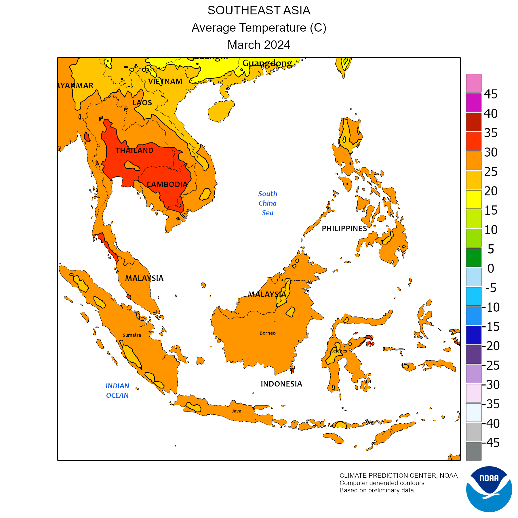
Map of Monthly Mean Temperature (°C)
| [3]
[3]
Countries
- Nepal (1)
- Bhutan (2)
- Bangladesh (3)
- Myanmar (4)
- Laos (5)
- Vietnam (6)
- Thailand (7)
- Cambodia (8)
- Malaysia (9)
- Indonesia (10)
- Philippines (11)
- Papua New Guinea (12)
- Brunei (13)
- Singapore (14)
- Timor-Leste (15)
- Paracel Islands (16)
- Spratly Islands (17)
- Jakarta, Indonesia (1)
- Manila, Philippines (2)
- Bangkok, Thailand (3)
- Ho Chi Minh City (Saigon), Vietnam (4)
- Kuala Lumpur, Malaysia (5)
- Singapore, Singapore (6)
- Yangon, Burma (Myanmar) (7)
- Bandung, Indonesia (8)
- Hanoi, Vietnam (9)
- Surabaya, Indonesia (10)
- Medan, Indonesia (11)
- Mekong River [4,909 km (3,050 mi)long]
- Salween River [2,815 kilometres (1,749 mi) long]
- Yarlung River [2,900 kilometers (1,802 miles) long]
- Yangtze River [6,418 kilometres (3,988 mi) long]
- Yellow River [5,464 kilometers (3,395 mi) long]
- Tonlé Sap, Cambodia [2700 – 16000 km²]
- Lake Toba, Indonesia [1130 km² (World’s largest volcanic lake)]
- Songkhla Lake, Thailand [1040 km²]
- Laguna de Bay, Philippines [940 km²]
- Lake Towuti, Indonesia [561 km²]
- Lake Jempang, Indonesia [450 km²]
- Lake Tempe, Indonesia [350 km²]
- Lake Lanao, Philippines [340 km²]
- Lake Poso, Indonesia [323 km²]
- Indawgyi Lake, Burma [300 km²]
Seas and Oceans:
- Java Sea (320,000 km²) [Depth: 151 feet (46 metres)]
- Sulu Sea [100,000 square miles (260,000 square km] [Depth:4400 meters (14,436 feet)]
- Celebes Sea [110,000 square miles (280,000 km2)] [Depth: 4000 meters (13,124 feet)]
- Timor Sea [610,000 km². (235,000 square miles)] [Depth: 3,300 m (10,800 ft)-200 m (650 ft)]
- South China Sea [3,500,000 square kilometres (Depth: 1,400,000 sq mi)] [18,000 ft (5,490 m)]
- Banda Sea [180,000 square miles (470,000 square km)] [Depth: 24,409 feet (7440 metres)]
- Andaman Sea [600,000 km2 (231,700 sq mi)] [Depth: 1,096 m (3,596 ft)-4,198 m (13,773 ft)]
- Phillipine Sea [2 million mi² (5 million km²)] [Depth: 34,440 feet (10,497 meters)]
- Molucca Sea [77,000 square miles (200,000 square km)] [Depth:15,780-foot (4,810-metre)]
- Arafura Sea [250,000 square miles (650,000 square km)] [Depth: 165 to 260 feet (50 to 80 metres)]
- Indian Ocean [73,556,000 square kilometres (28,350,000 sq mi)] [Depth: 12,760 feet (3,890 metres)-24,442 feet (7,450 metres)]
- Pacific Ocean [165.2 million square kilometres (63.8 million square miles)] [Depth: Up to 10,911 metres (35,797 ft)]
Natural Disasters
The Indonesian Volcanology Center has raised the alert from level II to Level III on Anak Krakatau Mt in Sunda Srait since the Sunday of September 30, 2011 following a number of volcanic quakes and increase of solfatara zone in the mountain flank.
In Philippines, June 2008 - Typhoon Fengshen sinks a ferry killing about 800 people, kills nearly 500 other people on land and leaves more than one million others homeless.
Mountains
Mountain Name , Elevation and Country
- Hkakabo Razi 5,881 m (19,295 ft) Myanmar (1)
- Ganlanrazi 5,834 m (19,140 ft) Myanmar (2)
- Dindawrazi 5,464 m (17,927 ft) Myanmar (3)
- Sheankalarazi 5,000 m (16,404 ft) Myanmar (4)
- Puncak Jaya 4,884 m (16,024 ft) Indonesia (5)
- Puncak Trikora 4,751 m (15,587 ft) Indonesia (6)
- Puncak Mandala 4,701 m (15,423 ft) Indonesia (7)
- Pangramrazi 4,655 m (15,272 ft) Myanmar (8)
- Phonnyinrazi 4,560 m (14,961 ft) Myanmar (9)
- Mount Kinabalu 4,095 m (13,435 ft) Malaysia (10)
- Mount Sarameti 3,826 m (12,552 ft) Myanmar (11)
- Mount Kerinci 3,805 m (12,484 ft) Indonesia (12)
- Rinjani 3,727 m (12,228 ft) Indonesia (13)
- Semeru 3,677 m (12,064 ft) Indonesia (14)
- Phonkanrazi 3,655 m (11,991 ft) Myanmar (15)
- Mount Lonkrumadin 3,185 m (10,449 ft) Myanmar (16)
- Fansipan 3,143 m (10,312 ft) Vietnam (17)
- Mount Agung 3,142 m (10,308 ft) Indonesia (18)
- Nat Ma Taung 3,109 m (10,200 ft) Myanmar (19)
- Mount Ramelau 2,963 m (9,721 ft) East Timor (20)
- Mount Apo 2,954 m (9,692 ft) Philippines (21)
- Mount Dulang-dulang 2,938 m (9,639 ft) Philippines (22)
- Mount Pulag 2,922 m (9,587 ft) Philippines (23)
- Phou Bia 2,819 m (9,249 ft) Laos (24)
- Mount Mawpie 2,813 m (9,229 ft) Myanmar (25)
- Mount Kalawitan 2,714 m (8,904 ft) Philippines (26)
- Mount Amuyao 2,702 m (8,865 ft) Philippines (27)
- Mount Trus Madi 2,642 m (8,668 ft) Malaysia (28)
- Doi Inthanon 2,565 m (8,415 ft) Thailand (29)
- Mayon Volcano 2,462 m (8,077 ft) Philippines (30)
- Mount Tahan 2,187 m (7,175 ft) Malaysia (31)
Mountain Ranges
- Annamese Cordillera (1)
- Central Southeast Asia (2)
- Malay Peninsula (3)
- Nagaland Hills (Nāga Hills) (4)
- Red-Mekong Area (5)
- Shan-Western Thailand (6)
- Luzon (7)
- Minidnao (8)
- Visayas (9)
- Pātkai Range (10)
- Chin Hills (11)
- Arakan Mountains (12)
Plateaus
- Plateau of Tibet (1)
- Shan Plateau (2)
- Korat Plateau (3)
Extreme Elevation Points:
- Lowest Elevation of Land: 4,000 feet below sea level on the Isthmus of Kra on the Malay Peninsula
- Lowest Elevation of Water: South China Sea (Ranging from 200-1000 meters below sea level)
- Highest Elevation: Mount Hkakabo [(5,881 m (19,295 ft)]
Science
Vietnam astronomy news-So far in 2011, the Ho Chi Minh City Amateur Astronomy Club (HAAC) has organized three major sky parties: the Fourth Annual Astronomy Camp of HAAC in March, an evening of the 30 Nights of StarPeace in Global Astronomy Month 2011 in April, and the Total Lunar Eclipse Observation Night on June 15 and 16.
Climate
The average temperature ranges from 59.5°F to 95°F, or 15.5°C to 35°C, except for parts of Papua New Guinea which ranges from 49.5°F to 59°F, or 5.5°C to 15°C
The average rainfall ranges from 38.5 in to 195.9 in, or 975 mm to 4974 mm, except for a part of southern Papua New Guinea, which has 196 in to 294.3 in, or 4975 mm to 7474 mm
The predicted temperature increase from 1960-1990 to 2070-2100 is 3°C [11]
All of Southeast Asia falls within the warm, humid tropics, and its climate generally can be characterized as monsoonal. It is subject to an extensive and regular monsoonal weather system (i.e., one in which the prevailing winds reverse direction every six months) that produces marked wet and dry periods in most of the region. Southeast Asia’s landscape is characterized by three intermingled physical elements: mountain ranges, plains and plateaus, and water in the form of both shallow seas and extensive drainage systems. The tropical rain belt causes additional rainfall during the monsoon season. The rain forest is the second largest on Earth. An exception to this type of climate and vegetation is the mountain areas in the northern region, where high altitudes lead to milder temperatures and drier landscape. Other parts fall out of this climate because they are desert like such as the La Paz Sand Dunes in in the province, Ilocos Norte, in the Northern Philippines and parts of Cambodia, Thailand, Laos and Myanmar which fall in the Tropical Savanna Climate region and have a dry winter season.
The water temperature is relatively warm because of the many coral reefs, which are bodies of shallow warm salt water. Indonesia has a reef area of 51,020 square kilometers. The Philippines have about 26,000 square kilometers of coral reef.
PRECIPITATION
Much of Southeast Asia receives more than 60 inches (1,500 millimetres) of rainfall annually, and many areas commonly receive double and even triple that amount. The rainfall pattern is distinctly affected by two prevailing air currents: the northeast (or dry) monsoon and the southwest (or wet) monsoon. The northeast monsoon occurs roughly from November to March and brings relatively dry, cool air and little precipitation to the mainland. As the southwestward-flowing air passes over the warmer sea, it gradually warms and gathers moisture. Precipitation is especially heavy where the airstream is forced to rise over mountains or encounters a landmass. The east coast of peninsular Malaysia, the Philippines, and parts of eastern Indonesia receive the heaviest rains during this period. The southwest monsoon prevails from May to September, when the air current reverses and the dominant flow is to the northeast. The mainland receives the bulk of its rainfall during this period. Over much of the southern Malay Peninsula and insular Southeast Asia there is little or no prolonged dry season. This is especially marked in much of the equatorial region and along the east coast of the Philippines. While the dry and wet monsoons are important in explaining rainfall patterns, so too are such factors as relief, land and sea breezes, convectional overturning and cyclonic disturbances. These factors often are combined with monsoonal effects to produce highly variable rainfall patterns over relatively short distances. While many of the cyclonic disturbances produce only moderate rainfall, others mature into tropical storms—called cyclones in the Indian Ocean and typhoons in the Pacific—that bring heavy rains and destruction to the areas over which they pass. The Philippines are particularly affected by these storms.
The salinity of the Indian Ocean is between 32 and 37 parts per thousand.
Mean Annual Precipitation in Meters
(Southeast Asia on the far right and far left side of the ocean currents map)

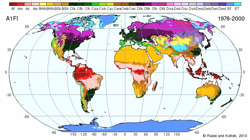
Map Showing Prediction of Climate Changes On Earth From 1980-2100 (120 years)

- Af: Tropical rainforest No dry season. The driest month has at least 2.40" (61 mm) of rain. Rainfall is generally evenly distributed throughout the year. All average monthly temperatures are greater than 64°F (18°C).
- Am: Tropical monsoonal Pronounced wet season. Short dry season. There are one or more months with less than 2.40" (61 mm). All average monthly temperatures are greater than 64°F (18°C). Highest annual temperature occurs just prior to the rainy season.
- Aw: Tropical savanna Winter dry season. There are more than two months with less than 2.40" (61 mm). All average monthly temperatures are greater than 64°F (18°C).
- BSh: Subtropical steppe Low-latitude dry. Evaporation exceeds precipitation on average but is less than potential evaporation. Average temperature is more than 64°F (18°C).
- BSk: Mid-latitude steppe Mid-latitude dry. Evaporation exceeds precipitation on average but is less than potential evaporation. Average temperature is less than 64°F (18°C).
- BWh: Subtropical desert Low-latitude desert. Evaporation exceeds precipitation on average but is less than half potential evaporation. Average temperature is more than 64°F (18°C). Frost is absent or infrequent.
- BWk: Mid-latitude desert Mid-latitude desert. Evaporation exceeds precipitation on average but is less than half potential evaporation. Average temperature is less than 64°F (18°C). Winter has below freezing temperatures.
- Cfa: Humid subtropical Mild with no dry season, hot summer. Average temperature of warmest months are over 72°F (22°C). Average temperature of coldest month is under 64°F (18°C). Year around rainfall but highly variable.
- Cfb: Marine west coast Mild with no dry season, warm summer. Average temperature of all months is lower than 72°F (22°C). At least four months with average temperatures over 50°F (10°C). Year around equally spread rainfall.
- Cfc: Marine west coast Mild with no dry season, cool summer. Average temperature of all months is lower than 72°F (22°C). There are one to three months with average temperatures over 50°F (10°C). Year around equally spread rainfall.
- Csa: Mediterranean Mild with dry, hot summer. Warmest month has average temperature more than 72°F (22°C). At least four months with average temperatures over 50°F (10°C). Frost danger in winter. At least three times as much precipitation during wettest winter months as in the driest summer month.
- Csb: Mediterranean Mild with cool, dry summer. No month with average temperature of warmest months are over 72°F (22°C). At least four months with average temperatures over 50°F (10°C). Frost danger in winter. At least three times as much precipitation during wettest winter months as in the driest summer month.
- Cwa: Humid subtropical Mild with dry winter, hot summer.
- Dfa: Humid continental Humid with hot summer.
- Dfb: Humid continental Humid with severe winter, no dry season, warm summer.
- Dfc: Subarctic Severe winter, no dry season, cool summer.
- Dfd: Subarctic Severe, very cold winter, no dry season, cool summer.
- Dwa: Humid continental Humid with severe, dry winter, hot summer.
- Dwb: Humid continental Humid with severe, dry winter, warm summer.
- Dwc: Subarctic Severe, dry winter, cool summer.
- Dwd: Subarctic Severe, very cold and dry winter, cool summer.
- ET: Tundra Polar tundra, no true summer.
- EF: Ice Cap Perennial ice.
- H: Complex zone Can encompass any of the above classifications due to the mountainous terrain.
Rocks, Minerals. and Gems in Southeast Asia
Sri Lanka: Graphite, Ilmenite, Gems, Mica, Lime Stone, Chinaclay, Apatite, and Silica
India: Coal, Copper, Mica, Petroleum, Gold, Phosphate, Gypsum, Bauxite, and Iron-ore
The Maldives: Salt and Lime stone
Pakistan: Petroleum, Gypsum, Lime stone, Silica, and Coal
Bangladesh: Limestone and Clay
Bhutan: Limestone, Bolomite, and Coal
Nepal: Mica, Copper, and Iron-ore
Malaysia, Indonesia, and Thailand account for half of the worlds tin production.
Indonesia, Malaysia, Brunei have significant reservations of oil and natural gas.
The Philippines has rich resources in gold, copper, chromites and manganese. The Sundaland peninsular core is considered the foremost source of tungsten and tin The Indonesia Islands formed by volcanoes. So the soil is extremely fertile because of the volcanic ash. Because of this, Indonesia is extremely rich in natural resources. Malaysia is rich in natural resources. Oil, natural gas, bauxite, coal, copper, gold, nickel, silver, and tin can be found. It has long ranked as a leading producer of rubber and tin, and of a vegetable oil called palm oil. The country also mines natural gas and petroleum.
Nepal: quartz, water, timber, hydropower, scenic beauty, small deposits of lignite, copper, cobalt, iron ore
Bhutan: timber, hydropower, gypsum, calcium carbonate
Bangladesh: natural gas, arable land, timber, coal
Laos: timber, hydropower, gypsum, tin, gold, gemstones
Vietnam: phosphates, coal, manganese, rare earth elements, bauxite, chromate, offshore oil and gas deposits, timber, hydropower
Thailand: tin, rubber, natural gas, tungsten, tantalum, timber, lead, fish, gypsum, lignite, fluorite, arable land
Cambodia: oil and gas, timber, gemstones, iron ore, manganese, phosphates, hydropower potential
Malaysia: tin, petroleum, timber, copper, iron ore, natural gas, bauxite
Indonesia: petroleum, tin, natural gas, nickel, timber, bauxite, copper, fertile soils, coal, gold, silver
Philippines: timber, petroleum, nickel, cobalt, silver, gold, salt, copper
Papua New Guinea: gold, copper, silver, natural gas, timber, oil, fisheries
Brunei: petroleum, natural gas, timber
Singapore: fish, deepwater ports
Timor-Leste: gold, petroleum, natural gas, manganese, marble
Spratly Islands: fish, guano, undetermined oil and natural gas potential
Tectonic Plates
Plate Boundaries
Southeast Asia consists of convergent boundaries. The directions of them are northeast and southwest.
Names of Plates
- Pacific Plate
- Philippine Plate
- Australian Plate
- Eurasian Plate
- Weh stratovolcano 617 metres (2,024 ft) Pleistocene 5.82°N 95.28°E
- Seulawah Agam stratovolcano 1,810 metres (5,940 ft) 1839 (2) 5.448°N 95.658°E
- Peuet Sague complex volcano 2,801 metres (9,190 ft) 25 December 2000 (2) 4.914°N 96.329°E
- Geureudong stratovolcano 2,885 metres (9,465 ft) 1937 4.813°N 96.82°E
- Kembar shield volcano 2,245 metres (7,365 ft) Pleistocene 3.850°N 97.664°E
- Sibayak stratovolcano 2,212 metres (7,257 ft) 1881 3.23°N 98.52°E
- Sinabung stratovolcano 2,460 metres (8,070 ft) 7 September 2010 3.17°N 98.392°E
- Toba supervolcano 2,157 metres (7,077 ft) unknown 2.58°N 98.83°E
- Helatoba-Tarutung fumarole field 1,100 metres (3,600 ft) Pleistocene 2.03°N 98.93°E
- Imun unknown 1,505 metres (4,938 ft) unknown 2.158°N 98.93°E
- Sibualbuali stratovolcano 1,819 metres (5,968 ft) unknown 1.556°N 99.255°E
- Lubukraya stratovolcano 1,862 metres (6,109 ft) unknown 1.478°N 99.209°E
- Sorikmarapi stratovolcano 2,145 metres (7,037 ft) 1986 (1) 0.686°N 99.539°E
- Talakmau complex volcano 2,919 metres (9,577 ft) unknown 0.079°N 99.98°E
- Sarik-Gajah volcanic cone unknown unknown 0.008°N 100.20°E
- Marapi complex volcano 2,891 metres (9,485 ft) 5 August 2004 (2) 0.381°S 100.473°E
- Tandikat stratovolcano 2,438 metres (7,999 ft) 1924 (1) 0.433°S 100.317°E
- Talang stratovolcano 2,597 metres (8,520 ft) 12 April 2005 (2) 0.978°S 100.679°E
- Kerinci stratovolcano 3,800 metres (12,500 ft) 22 June 2004 (2) 1.697°S 101.264°E
- Hutapanjang stratovolcano 2,021 metres (6,631 ft) unknown 2.33°S 101.60°E
- Sumbing stratovolcano 2,507 metres (8,225 ft) 23 May 1921 (2) 2.414°S 101.728°E
- Kunyit stratovolcano 2,151 metres (7,057 ft) unknown 2.592°S 101.63°E
- Pendan unknown unknown unknown 2.82°S 102.02°E
- Belirang-Beriti compound 1,958 metres (6,424 ft) unknown 2.82°S 102.18°E
- Bukit Daun stratovolcano 2,467 metres (8,094 ft) unknown 3.38°S 102.37°E
- Kaba stratovolcano 1,952 metres (6,404 ft) 22 August 2000 (1) 3.52°S 102.62°E
- Dempo stratovolcano 3,173 metres (10,410 ft) October 1994 (1) 4.03°S 103.13°E
- Patah unknown 2,817 metres (9,242 ft) unknown 4.27°S 103.30°E
- Bukit Lumut Balai stratovolcano 2,055 metres (6,742 ft) unknown 4.23°S 103.62°E
- Besar stratovolcano 1,899 metres (6,230 ft) April 1940 (1) 4.43°S 103.67°E
- Ranau caldera 1,881 metres (6,171 ft) unknown 4.83°S 103.92°E
- Sekincau Belirang caldera 1,719 metres (5,640 ft) unknown 5.12°S 104.32°E
- Suoh caldera 1,000 metres (3,300 ft) 10 July 1933 (4) 5.25°S 104.27°E
- Hulubelu caldera 1,040 metres (3,410 ft) 1836 5.35°S 104.60°E
- Rajabasa stratovolcano 1,281 metres (4,203 ft) 1798 5.78°S 105.625°E
Basic Facts
Area: 1,900,000 sq. mi.
Population: 593,000,000.
Population Density: 306/sq. mi.
Approximate latitude: 28°N to 12°S
Approximate longitude: 93°E to 140°E
Time Zones: UTC+5:30 to UTC+9:00
Languages: Khasi, Khumer, Mon, Kuy, Nicobarese, Vietmanese, Santali, Hmongic Languages, Mienic Languages, Gelao, Buyang, Hlai, Zhuang, Lao, Nyaw, Thai, Atayal, Paiwan, Cebuano, Hiligaynon, Ilokano, Tagalog, Cham, Indonesian, Japanese, Malay, Sundanese, Tetum, Bodo, Burmese, Chin Languages, Dzongkha, Jingpho, Karen, Kayah, Kiranti Languages, Meitei, Mizo, Rahkine, Tibetan, and Tamil... (wow!)
Southeast Asia stretches some 4,000 miles at its greatest extent (roughly from northwest to southeast) and encompasses some 5,000,000 square miles (13,000,000 square kilometres) of land and sea, of which about 1,736,000 square miles is land.
Largest Cities
Major Bodies of Water
Rivers:

All are or subduction zones, with the Pacific Plate subducting under the Philippine and Australian Plate. The Philippine Plate is subducting under the Eurasian Plate. The Pacific, Philippine, and Australian Plates are mostly oceanic crust. The Eurasian is mainly continental crust.
Earthquakes
Many earthquakes have happened for the past week, especially around areas near Indonesia. Earthquakes that happened in the past day include some in the Celebes Sea, Molucca Sea, off the north coast of Papua New Guinea, two off the north coast of Northern Sumatra, and one in the Indian Ocean.
Volcanoes
An entire chain of volcanoes run throughout the islands of the Philippines and Indonesia. Indonesia has at least 150 active volcanoes. Indonesia is notorious for having the supervolcano, Toba, which erupted about 70,00 years ago and caused a global catastrophe. Many of the islands in the Philippines are of volcanic origin and the islands are situated in the Ring of Fire.
Some active volcanoes in the Philippines are the Ambalatungan Group, Babuyan Claro, Banahaw, Biliran, Bulusan, Cagua, Camiguin de Babuyanes, Didicas, Hibok-Hibok, Iraya, Iriga, Jolo Group, Kanlaon, Leonard Kniaseff, Makaturing, Matutum, Mayon, Musuan, Parker, Pinatubo, Ragang, San Pablo Volcanic Field, Smith, and Taal.
List of Indonesian volcanoes:
Name Shape" "Elevation" "Last Eruption" "Geolocation"
![[1]](http://www.google.com/imgres?q=pictures+of+flags+of+southeast+asia&hl=en&biw=1052&bih=784&gbv=2&tbm=isch&tbnid=kFp_bbz4ynKYvM:&imgrefurl=http://www.retire-asia.com/asia-destinations.shtml&docid=s6y6cxsDDZkeRM&imgurl=http://www.retire-asia.com/asean.png&w=482&h=190&ei=8RjQTumsDaa3sQK26IHYDg&zoom=1&iact=hc&vpx=65&vpy=178&dur=9081&hovh=141&hovw=358&tx=269&ty=62&sig=114102442009973286785&page=1&tbnh=82&tbnw=208&start=0&ndsp=20&ved=1t:429,r:0,s:0)
![[2]](http://www.google.com/imgres?q=southeast+asia&hl=en&gbv=2&biw=1113&bih=749&tbm=isch&tbnid=t_fIyG3k_-zsNM:&imgrefurl=http://wikitravel.org/en/Southeast_Asia&docid=vy7ZB86QLW6E1M&imgurl=http://wikitravel.org/upload/shared//thumb/2/21/Map_of_Southeast_Asia.png/400px-Map_of_Southeast_Asia.png&w=400&h=353&ei=_eq2TtGkKqXisQLRgvjNAw&zoom=1&iact=hc&vpx=105&vpy=188&dur=17&hovh=211&hovw=239&tx=137&ty=125&sig=102569257010269787892&page=1&tbnh=153&tbnw=173&start=0&ndsp=17&ved=1t:429,r:0,s:0)
![[6]](http://old.japanfocus.org/data/tibet.w.chi.rivers.jpg)
![[7]](http://3.bp.blogspot.com/_QH_mtdTQUk8/S-rPqp7YCEI/AAAAAAAAAAw/XTMAR3RwgHc/S1600-R/map+Southeast+Asia.jpg)
![[12]](http://www.google.com/imgres?q=list+showing+countries,+area,+population,+density+and+capitals+of+southeast+asia&hl=en&biw=1052&bih=784&gbv=2&tbm=isch&tbnid=tQOfomy_Ou998M:&imgrefurl=http://www.eepsea.cc-sea.org/pages/resource/sociecon.html&docid=vnsLzO3UVmYPBM&imgurl=http://www.eepsea.cc-sea.org/images/precip.gif&w=600&h=396&ei=5xbQTsmiDtDhsQK65cHeDg&zoom=1&iact=hc&vpx=701&vpy=147&dur=695&hovh=182&hovw=276&tx=159&ty=66&sig=114102442009973286785&page=6&tbnh=114&tbnw=173&start=106&ndsp=22&ved=1t:429,r:4,s:106)