Earth Science 7 - Indonesia 8
Indonesia
Contents
- 1 Island Groups
- 2 Latitude/ Longitude
- 3 Elevation Range
- 4 Large Bodies of Water
- 5 Major Topographic Features
- 6 Average Precipitation
- 7 Average Temperatures
- 8 Climate Zone
- 9 Climate
- 10 Geology
- 11 Minerals and Mining Recourses
- 12 Rock Types
- 13 Volcanoes
- 14 Earthquakes
- 15 Rocks and Relationship with Tectonic Activity
Island Groups
Borneo, Java, Lesser Sunda Islands, Molucca Islands, Papua Sulawesi, and Sumatra
Indonesia is an archipelago of 17,508 islands. [1]
Latitude/ Longitude
5 degrees S and N, 120 degrees E and W. This location is near the equator so temperature rises and creates a hi pressure zone. [2]
Elevation Range
Lowest- Indian Ocean, 0 meters [3] The Temperature on the Indian Ocean can range from82 degrees F to 72 degrees F. Also, the air is over an ocean and this can cause rain and monsoons. [4]
Highest- Puncak Jaya, 5,030 meters [5] The temperature at Puncak Jaya can range from 28 degrees F to 60 degrees F. This means there is snow and that this is a high pressure area causing snow storms and blizzards. [6]
Large Bodies of Water
Oceans- Indian Ocean, Atlantic Ocean
Seas- Andaman Sea, South China Sea, Banda Sea, Timor Sea, Arafura Sea, Java Sea, Philippine Sea, Celebes Sea [7]
Ocean currents affect the climate because a current is moving water. And with moving water comes heat. When the air heats it capacity to hold water increases and rain occurs more often. Also water is very close to the islands so rain and storms occur often do to high humidity. [8]
Major Topographic Features
Climate: Tropical; hot, humid, more moderate in highlands
Terrain: mostly coastal lowlands; larger islands have interior mountains, also swamp forest. Because the mountains are on islands they are close to water. The water freeze and forms snow. Other times when there is a lot of rain place get flooded and create swamps. There are 48,000 different plant species. The vegetation reduces carbon dioxide and creates oxygen. Also the trees create shade which lowers the temperature.The Prevailing winds also contribute to the climate. The prevailing winds interact with mountains and valleys and create differences in rain fall and temperature. [9] [10] [11]
Average Precipitation
| Rainfall | Jan | Feb | Mar | Apr | May | Jun | Jul | Aug | Sep | Oct | Nov | Dec | Ann Total |
| Average | 13.7 in | 11.3 | 8.4 | 3.7 | 3 | 2.8 | 2 | 0.9 | 1.6 | 3.6 | 6.1 | 11.5 | 68.6 |
Average Temperatures
| Temps | Jan | Feb | Mar | Apr | May | Jun | Jul | Aug | Sep | Oct | Nov | Dec | Ann |
| Max | 30 | 30 | 31 | 32 | 32 | 32 | 32 | 32 | 32 | 32 | 32 | 32 | 31 |
| Min | 24 | 24 | 24 | 24 | 24 | 24 | 24 | 24 | 24 | 24 | 24 | 24 | 24 |
Climate Zone
Indonesia is in the Af, Am, Aw category.
Af: Tropical rain forest climate
Am:Tropical wet and dry or savanna climate
Aw: Tropical monsoon climate [15]
Climate
Jakarta is the capital of Indonesia. Its latitude is 6° 12’S and this means that the area of Jakarta city is the most adjacent major city of Java to the equator line. Jakarta’s proximity to the equator gives the city a mostly warm and tropical climate. However, despite being located relatively close to the equator, the city has distinct wet and dry seasons. Wet seasons in Jakarta cover the majority of the year, running from November through June. The remaining four months forms the city’s dry season. Jakarta’s elevation is 7m (23ft) above sea level. Air that is denser will hold heat much better than air that is less dense, so at lower elevations you will have warmer temperatures. Since Jakarta lies in a low, flat basin its topography is low. This makes Jakarta prone to flooding from swollen rivers in the wet season and high tides. The city is located at the Western-most tip of the island Java. And since water has a high specific heat, it takes longer to heat up and cool off, affecting the temperature of the land it is near. Also, moisture from the Java Sea causes fog, clouds, and rain in Jakarta. Since winds on the island of Java come from the Java Sea, Jakarta’s climate is more moderate than if its prevailing winds blew over land. This also affects the amount of precipitation. (There will be more precipitation). Due to this and other factors, Jakarta’s climate can be considered a “marine” climate as opposed to a “continental” climate. For the most part, Java (including Jakarta), is a region covered with the luxuriant growth of the characteristic rain forest vegetation, a type of ever-wet vegetation containing a large number of timber species. Vegetation affects climate primarily through transpiration. Since the area of the island of Java contains a large number of trees and other vegetation, it gets a high amount of precipitation as rain. For example: the Amazon rain forest has extremely dense vegetation. Because of this it rains almost every day. Also, places with dense vegetation are cooler in the summer but are prone to be extremely humid. Jakarta is located in an area of low pressure. Since changes in air pressure give a simple, although not always accurate, way of forecasting weather, … (for example: A decrease in air pressure often signals the approach of warmer, more humid air, along with precipitation such as rain or snow. On the other hand, an increase in air pressure often signals the arrival of cooler, drier air and fair weather conditions.) …we can understand that Jakarta’s positioning in a zone of lower air pressure partially causes warm, humid air, and frequently plausible rain. Ocean currents are one of the main factors that affect climate. And the reason why is because a current is water that travels and with that http://wiki.sjs.org/wiki/skins/common/images/button_media.pngtraveling water comes heat. The S. Equatorial ocean current flows away from the equator in an counter-clockwise flow carrying warm water. This warm-water current intersects with the city of Jakarta and the island of Java, bringing even warmer temperatures.
Geology
Minerals and Mining Recourses
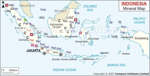
Indonesia is an important producer of oil and natural gas. The country also ranks as one of the world's largest exporters of natural gas. Most of Indonesia's petroleum comes from East Kalimantan and Sumatra. Indonesia is also a leading country in the mining of copper, nickel, and tin. Most of Indonesia’s copper comes from Papua. Nickel is mined on Sulawesi. The islands of Bangka and Belitung have many tin mines. Indonesia's other mineral products include aluminum, bauxite, coal, gold, and silver.[16]
Rock Types
There are many volcanoes located along the southern part of Sumatra, Java, Bali Lombok, and Flores. This means most of the igneous rocks are located here. Most of the Metamorphic rocks are located on the inside of major islands like Kalimantan and Papua. Kalimantan and Papua are both located near two tectonic plates. The two plates are the Philippines Plate and the Australian Plate. These tectonic plates are the reason for the metamorphic plates because they cause great amounts of heat and pressure or regional metamorphism. Finally the sedimentary rocks are located on the outside of Kalimantan and Papua, and the northern part of Sumatra, Java, Bali Lombok, and Flores. Sedimentary take up most of Indonesia because there are many rivers located in Indonesia. Such as Musi, a large river, located in south Sumatra.[18]


Tectonic Plates
Indonesia is located on the Eurasian Plate. The Eurasian Plate is surrounded by convergent and divergent boundaries. A convergent boundary is where two plates converge forming mountains. A divergent boundary on the other hand is where two plate move apart forming rift valleys. The continental margins in indonesia are mostly active due to the subduction boundaries that create a lot of volcanoes along the island of Sumatra.
Volcanoes
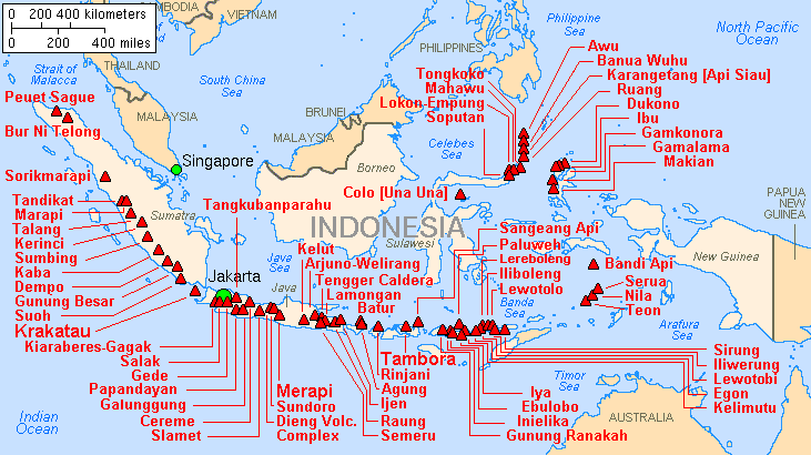
There are over 60 volcanoes that have erupted since 1900. Most volcanoes are located along the island of Sumatra. A few volcanoes that are located here are Tandikat, Marapi, Talang, Kerinci, Sumbing, and Kaba. Along with Sumatra many volcanoes are located on Sulawesi a small island East of sumatra. The names of the major volcanoes here are Tongkoko, Mahawu, Lokon-Empung Awu, Banua Wuhu, and Ibu. Most volcanoes are composite volcanoes like Kaba, that are create from convergent subduction boundaries; also cinder cone volcanoes are common and are found near a composite volcano but there are a few volcanoes that are shield volcanoes that are created on hotspots like Nila or Teon. These are the names and dates of all the recent eruptions in indonesia, Lamongan on March 11, 2012, Lokon on February 10, 2012, Semeru on February 3, 2012, Lewotolo on January 8,2012. One of the most historical eruptions was Mount Tambora. In Indonesia it was the largest-ever volcanic eruption in 1815 killing 100,000 people. There is little known about it due to lack of media.
Earthquakes
Many of earthquakes have occurred in indonesia. Most earthquakes are located on or near Sumatra along with Java, Nias Region, and Halmahera. All of the recent volcanoes are located in Sumatra and Java. There have been 8 earthquakes since 2010 all ranging from a 6.6 magnitude to a 8.6 magnitude. There was two earthquakes off the west coast of Northen Sumatra in March11, 2012 with a magnitude of 8.6 and 8.2, then one on January 10, 2012 with a 7.3, one on September 5, 2011, with a 6.6, one on March 3, 2011 with a 6.7, one on October 25, 2010 with a 7.7, one on May 19, 2010, and finally one on March 6, 2010. A significant earthquake occurred March 11, 2012 with a magnitude of 8.6. This earthquake created a large Tsunami. [23]
Rocks and Relationship with Tectonic Activity
There is a lot of Basalt and Gabbro from the hotspot and shield volcanoes in Indonesia. Along with Basalt and Gabbro there is Granite, Obsidian, and Pumice from the composite volcanoes located on Sumatra.
"References"
- ↑ The World Book Encyclopedia. Chicago: World Book, Inc., 2007. Print.
- ↑ http://www.cia.gov/library/publications/the-world-factbook/geos/id.html
- ↑ http://www.cia.gov/library/publications/the-world-factbook/geos/id.html
- ↑ http://www.britannica.com/EBchecked/topic/285876/Indian-Ocean/22776/Surface-temperatures
- ↑ http://www.cia.gov/library/publications/the-world-factbook/geos/id.html
- ↑ http://www.snow-forecast.com/resorts/Carstensz-Pyramid
- ↑ http://www.cia.gov/library/publications/the-world-factbook/geos/id.html
- ↑ http://www.tech-faq.com/how-do-ocean-currents-affect-climate.html
- ↑ http://www.britannica.com/EBchecked/topic/286480/Indonesia/275943/Plant-and-animal-life
- ↑ http://www.cia.gov/library/publications/the-world-factbook/geos/id.html
- ↑ http://www.nationsencyclopedia.com/Asia-and-Oceania/Indonesia-TOPOGRAPHY.html
- ↑ http://www.weather.com/
- ↑ http://weather.uk.msn.com/cgi-bin/data.pl?ref=N03E098+1200+0002542G2
- ↑ http://weather.uk.msn.com/monthly_averages.aspx?wealocations=wc:IDXX0022
- ↑ http://www.meteorologyclimate.com/koppenclassification.htm
- ↑ http://www.worldbookonline.com/advanced/article?id=ar275460&st=minerals+in+indonesia
- ↑ http://www.google.com/imgres?q=indonesia+mining+map&hl=en&client=safari&sa=X&rls=en&biw=1361&bih=648&tbm=isch&prmd=imvns&tbnid=uucuMNPrmsHc_M:&imgrefurl=http://www.mapsofworld.com/indonesia/indonesia-mineral-map.html&docid=AuyxngBi7a5fvM&imgurl=http://www.mapsofworld.com/indonesia/maps/indonesia-mineral-map.jpg&w=525&h=269&ei=KkZVT5HQM5T1sQKdz5XwBQ&zoom=1&iact=rc&dur=347&sig=112085412402278922063&page=1&tbnh=91&tbnw=177&start=0&ndsp=18&ved=1t:429,r:5,s:0&tx=40&ty=46
- ↑ http://en.wikipedia.org/wiki/File:INDONESIA_geology_map.jpg
- ↑ http://www.google.com/imgres?q=regional+geology+of+indonesia&hl=en&client=safari&sa=X&rls=en&biw=1361&bih=648&tbm=isch&prmd=imvns&tbnid=9Fg2iAb2lHdRUM:&imgrefurl=http://en.wikipedia.org/wiki/File:INDONESIA_geology_map.jpg&docid=JWC8ITCYn_M3KM&imgurl=http://upload.wikimedia.org/wikipedia/commons/5/5b/INDONESIA_geology_map.jpg&w=780&h=483&ei=20ZVT8CkAaWEsALR0JHwBQ&zoom=1&iact=hc&vpx=354&vpy=158&dur=1186&hovh=177&hovw=285&tx=178&ty=73&sig=112085412402278922063&page=1&tbnh=109&tbnw=176&start=0&ndsp=18&ved=1t:429,r:1,s:0
- ↑ http://www.state.gov/p/eap/ci/id/
- ↑ http://www.volcanolive.com/news.html
- ↑ http://en.wikipedia.org/wiki/File:Map_indonesia_volcanoes.gif
- ↑ http://en.wikipedia.org/wiki/List_of_earthquakes_in_Indonesia