Earth Science 7 - Middle East3
Earth Science 7-Global Regions Index
Contents
- 1 Middle East
- 2 Countries
- 3 Latitude and Longitude
- 4 Elevation
- 5 Major Bodies of Water
- 6 Oceans
- 7 Topographical Features
- 8 Climate in Different Countries
- 9 Climate using Koppen System
- 10 Capitals and Government System
- 11 Facts
- 12 Minerals and Natural Resources
- 13 Rocks
- 14 Plate Tectonics
- 15 Volcanoes
- 16 Earthquakes
- 17 References
Middle East

Countries
There are 21 countries in the Middle East. These are Afghanistan, Bahrain, India, Iran, Iraq, Israel, Jordan, Kuwait, Kyrgyzstan, Lebanon, Oman, Pakistan, Qatar, Saudi Arabia, Syria, Tajikistan, Turkey, Turkmenistan, United Arab Emirates, Uzbekistan, and Yemen.
Latitude and Longitude
The latitude is 46 degrees north to 14 degrees north. The longitude is 78 degrees east to 27 degrees east.
Elevation
The highest mountain peak in the middle east is located at the Syria Jabal Al Shaykh mountain,aka Mount Hermon or in Arabic: جبل الشيخ The tip of the mountain is 2814m above sea level (9232) ft. Its summit hovers over Syria and Lebanon. The lowest point in the middle east is the shoreline of the Dead Sea, which borders Israel and Jordan, and is actually known as the lowest point on the Earth. Elite researches claim that the Dead Sea was 1,293 feet below shoreline 40 years ago, and it is now 1,360 feet below shoreline.
Major Bodies of Water
The large bodies of water near the middle east are the...
-Arabian Sea-south of the Middle East
-the Aral Sea-north of Uzbekistan
-the Black Sea-north of Turkey
-the Caspian Sea-north of Iran
-the Gulf of Aden-south of Yemen
-the Gulf of Oman-between Iran and Oman
-the Mediterranean Sea-between Europe and Africa and to the West of the Middle East
-the Persian Gulf-bordered by Iran, Kuwait, Saudi Arabia, Bahrain, Qatar, U.A.E., and Oman
-the Red Sea-by Africa and the Arabian peninsula.
-the Dead Sea-between Israel and Jordan
Oceans
There is no ice cover in the Middle East.
Tides are very limited as a result of the narrow connection with the Atlantic Ocean. The maximum tidal range is 3.5 to 4 meters.
There are no upwellings on the coast of the Middle East.
Due to the warm water current flowing by the southeast coast of the Middle East, the water is less dense.
There are no countercurrents on the coast of the Middle East.
The North Equatorial Current is a warm current that flows along the south east coast of the middle east.
Evaporation is more abundant than the combined forces of precipitation and river runoff in the Mediterranean, affecting the water circulation within the basin. The quantity of fresh water flowing into the Mediterranean from rivers is only one-third of the amount lost through evaporation. Evaporation is especially high in its eastern half, causing the water level to decrease and salinity to increase eastward. This imbalance causes a pressure gradient which draws relatively cool, low-salinity water from the Atlantic across the basin; it warms and becomes saltier as it travels east, then sinks in the region of the Levant and circulates westward, to spill over the Strait of Gibraltar. Thus, seawater flow is eastward in the strait's surface waters, and westward below; once in the open ocean, this chemically-distinct "Mediterranean Intermediate Water" can persist thousands of kilometers away from its source.
Salinity in the mediterranean sea is about 38 parts per thousand, except in the area closest to the Atlantic, which is where the mediterranean water comes from. The salinity near the eastern part of the mediterranean during summer is abot 40 parts per thousand.Salinity of the deep water is about 38.4 parts per thousand.
The Mediterranean has three layers of water masses; a surface layer, an intermediate layer, and a deep layer that sinks to the bottom. Measurements of the rate at which the deep layer forms and sinks, and studies of heat and water exchange in the Mediterranean provide useful models for understanding the impact of global climactic change on the world’s oceans.
Topographical Features
The Middle Eastern region is home to vast petroleum reserves, major oil production facilities, and large oil refineries, which provide their host nations with enormous incomes. Much of the Middle East is arid, and the region's topography features extensive desert areas, rugged mountains, and dry plateaus. Water is in short supply, and agriculture often depends on expensive irrigation systems.
Important Landforms are
ANATOLIAN PLATEAU This generally barren and arid plateau of central Turkey averages about 500 meters in elevation. Farming and livestock raising (the major industries), are difficult occupations here as extreme temperatures, both summer and winter are commonplace. Regardless, scattered towns and villages cover the landscape.
AN NAFUD DESERT (part of the Arabian Desert) This desert of western Saudi Arabia is famous for gigantic sand dunes, some reaching over 100 ft.high.
AR RUB' AL KHALI DESERT (Empty Quarter) also (Arabian Desert) Known as the Empty Quarter, it's the largest (only sand) desert in the world and famed for huge sand dunes that can extend for over 25 miles. It covers most of southern Saudi Arabia, and is almost moistureless. The Ad Dahna' is the northern expanse that connects to the An Nafud Desert.
The Arabian Desert is approximately 1,000,000 sq miles in total size.
ASIR & HEJAZ MOUNTAINS Running along Saudi Arabia's border with the Red Sea, this range of lower mountains averages 6,000 - 7,000 ft. (1,829 - 2,130m)
CAUCASUS MOUNTAINS Located between the Black and Caspian Seas, these mountains dominate the landscape of Armenia, Azerbaijan and Georgia (all part of southeastern Europe,) where the Middle East begins. Many of the volcanic peaks here exceed 15,000 ft., with the highest point being Mt. Elbrus at 18,481 ft. (5,633m).
DASH -E LUT (Lout Desert) This region of eastern Iran is an arid, wind-blown desert, completely surrounded by mountains. In the summer months, it can be one of the hottest and driest spots on the planet. In some areas here rain has not been measured.
DASHT -E KAVIR (Kavir Desert) This plateau of north-central Iran is often referred to as the "Great Salt Desert." It's the largest desert in the country and is mostly uninhabited wasteland covered with crusty salt ridges.
ELBURZ MOUNTAINS (or Alborz) Extending for almost 620 miles along Iran's northern border with the Caspian Sea, these jagged mountains average over 9,000 ft, with the highest point being Mt. Damavand, a dormant volcano, at 18,602 ft.(5,670m)
HADRAMAWT This low mountain range (and region) of Yemen averages about 3,500 ft. (1,067m), with the highest peak estimated at 8,000 ft., (2,440m).
HINDU KUSH These dramatic mountains form a natural border between Afghanistan and Pakistan, with many snow-capped peaks reaching over 22,000 ft. The highest point is Tirich Mir at 25,282 ft. (7,706m).
KARA KUM DESERT This desert of south-central Turkmenistan is a large mass of sand known for its towering sand dunes extending in all directions. It's about 115,000 sq. miles in size.
PAMIR This region and its namesake mountains stretch across much of Tajikistan and parts of Afghanistan, China and Pakistan, and similar to the Hindu Kush, numerous peaks exceed 22,000 ft, with the highest point being Pik Samani at 24,590 ft. (7,495m).
SYRIAN DESERT At approximately 200,000 sq, miles (518,000 sq, km) it covers parts of Jordan, Syria, Saudi Arabia and western Iraq. Very little rain falls in this arid wasteland, however, Arab nomads inhabit the desert and successfully raise cattle and camels. Oil pipelines are commonplace, as well as scattered oases.
TAURUS MOUNTAINS This rugged chain extends across southern Turkey to its borders with Iraq and Iran. The highest point (Mt. Ararat) is located in the Eastern Taurus range. This extinct volcano is 16,583 ft. (5,137m) high. It is felt by biblical historians that Noah's Ark landed here.
The Koroglu and Ponic ranges stretch along the Black Sea coast of northern Turkey.
TIEN SHAN (also Tian) Stretching almost 1,500 miles across Kyrgyzstan and well into China, this multiple range of mountains commonly exceed 19,000 ft., with the highest point being Pik Pobeda at 24,407 ft. (7,439m).
ZAGROS MOUNTAINS The many ranges of the Zagros extend along southern and western Iran and into northern Iraq. Many peaks exceed 9,000 ft., with the highest point being Zard Kuh at 14,921 ft. (4,548m).
Climate in Different Countries
Four of the major types of climate are arid deserts, mediterranean, subtropical, and temperate. Some examples of arid desert climate are Afghanistan, Bahrain, Iran, Jordan, Kuwait, Oman, Qatar, Pakistan (mostly), Saudi Arabia, Syria, Tajikistan, Uzbekistan, U.A.E. and Yemen. These middle east countries experience desert climate because they are all mid-continent countries away from water and they experience a lack of moisture. These countries don't experience local winds or heavy rains for the most part. They also contain long area of flat land such as the Oman desert that is subject to the harshest of the sun's energy beating down on them. These countries are mostly located near the equator. Examples of wet or mediterranean countries are Cyprus, Iran, Jordan in the west, and Lebanon. These countries are all near the Mediterranean sea and have the characteristics of the Mediterranean, which is warm to hot, dry summers and mild to cool, wet winters. The temperate climate is known for its relatively moderate changes in temperature and weather. The north temperate zone extends from the tropic of cancer (23.5 degrees north) to the arctic circle (at approximately 66.5 degrees north) This is the temperate zone that Cyprus, Israel, Kyrgyzstan (which has the fortunate ability to contain mountains and be arid, subtropical, temperate and Mediterranean) reside in. Within the temperate borders there are many climate types that are influenced by local factors like being nearby the ocean or being in the mountains. Lastly, parts of the middle set are the subtropical climate. The subtropical climate is found just outside the tropics of Cancer and Capricorn, at 23.5 degrees north to 40 degrees north. The subtropics are in places along the coast that are wet and humid such as Iran, Kyrgyzstan, and Turkmenistan.
Afghanistan: arid or semiarid with cool winters and dry summers
Bahrain: arid; mild, pleasant winters; very hot, humid summers
Cyprus: Cyprus is temperate; Mediterranean with hot, dry summers and cool winters
Iran: Iran is greatly arid or partial arid, subtropical along Caspian coast
Israel: Israel is temperate; hot and dry in southern and eastern desert areas
Jordan: Jordan can be mostly arid desert; rainy season in west (November to April)
Kuwait: Kuwait contains dry desert,intensely hot summer, with short cool winters
Kyrgyzstan: Kyrgyzstan dry continental to polar high in Tien Shan (mountain range covering most of Kyrgystan) subtropical in southwest (the Fergana Valley) temperate in northern foothill zone
Lebanon: Lebanon is Mediterranean; mild to cool, wet winters with hot, dry summers; Lebanon mountains are subject to heavy winter snows
Oman: Oman is desertland, and is known for its desert 1,000 miles long!
Qatar: Hot and humid summers and winter is cool
Pakistan: Pakistan is mostly hot, dry desert; temperate in northwest; arctic in north
Saudi Arabia: Saudi Arabia is a harsh, dry desert with radical temperature extremes
Syria: Syria is made of mostly desert, hot, dry, sunny summers (which is June to August) and mild, rainy winters (which is December to February) along coast; cold weather with snow or sleet periodically in Damascus
Tajikistan: Tajikistan is midlatitude continental, hot summers, mild winters; semiarid to polar in Pamir Mountains (which, along with the Alay Mountains controls most of the landscape)
Turkey: Turkey is temperate, contains hot, dry summers with mild, wet winters; harsher in interior
Turkmenistan: Turkmenistan is completely subtropical desert
U.A.E: the United Arab Emirates are cooler in eastern mountain, and desert
Uzbekistan: Uzbekistan is mostly midlatitude desert, long, hot summers, mild winters; semiarid grassland in east
Yemen:Yemen is mostly desert; hot and humid along west coast; temperate in western mountains affected by seasonal monsoon; extraordinarily hot, dry, harsh desert in east
Climatology for Southwest Asia – including Afghanistan and Iraq
REGIONAL CLIMATE MAPS: MIDDLE EAST
 NOAA’s National Climate Data Center
Climate using Koppen System
-Mostly hot arid desert
-Equatorial Monsoonal
-Warm temperature summer dry arid
-Equatorial Winter dry
-hot arid steppe
Capitals and Government System
Afghanistan: Kabul, Islamic republic
Bahrain: Manama, Constitutional Monarchy
Cyprus: Nicosia, Republic
Iran: Teheran, Theocratic Republic
Israel: Jerusalem, Parliamentary Democracy
Jordan: Amman, Constitutional Monarchy
Kuwait: Kuwait City, Constitutional Emirate (Fun fact: Emirate means it has an Emir (Head of state) at its head!)
Kyrgyzstan: Bishkek, Republic
Lebanon: Beirut, Republic
Oman: Muscat, Monarchy
Qatar: Doha, Emirate
Pakistan: Islamabad, Federal Republic
Saudi Arabia: Riyadh, Absolute Monarchy
Syria: Damascus, Republic under an authoritarian military-dominated regime
Tajikistan: Dushanbe, Republic
Turkey: Ankara, Republican Parliamentary Democracy
Turkmenistan: Ashgabat, Republic
U.A.E: Adu Dhabi, Emirate
Uzbekistan: Tashkent, Republic
Yemen: Sanaa, Republic
Facts
April 7, 2003 — Geologists say that millions of years ago the Middle East had a mild, humid climate, with large areas covered by a shallow continental sea. When the single-celled planktonic plants and animals living in that sea died, they sank to the bottom and were covered by soil sediments and other plankton. Over time, they decayed into oil — an important fossil fuel that is this region’s most valuable natural resource. Today, much of this region is part of the large subtropical desert that extends across North Africa and southern Asia.
Except for the areas inside the mountains, the low rainfall in Iraq makes it possible for it to be called a desert. Iraq's average rainfall is usually in between 4 and 7 in. per year. 90% of precipitation occurs between the months of November and April. In the mountainous filled land areas, the rainfall is higher, between about 12 and 24 in. per year, which is enough water to support crops (although the unorthodox land often limits agriculture in this area).
Rainfall is even harder to find to the south because it has an average annual precipitation rate of 1.5 in. at Badanah in the northern interior of Saudi Arabia. Precipitation in this area, like most deserts, varies considerably from month to month and year to year. For example, Riyadh, Saudi Arabia, had 5.2 inches of rain during its rainiest ever month, which is well over the annual average of 3.8 inches. Desert rains also frequently occur in abundant downpours. The greatest 24-hour rainfall at Hail, Saudi Arabia was 2.5 inches, which is almost the same as the annual average of 2.6 inches. On the other hand, months often go by with no rainfall at all, so its important to know when to buy a rain jacket to minimize the chances of being caught unawares.
Usually, approximately 90 % of the annual rainfall falls between the months of November and April, while the remaining 6 months (particularly the hottest ones of June, July and August, aka summer) are dry and arid. Rainfall from February through April averages from about 0.6 in. at Badanah to 2.4 in. at Baghdad — which is 1/3 to 1/2 their respective annual rainfall.
Thunderstorms sometimes collaborate in unison with the rain, particularly in the spring when, on average, the eastern edges of the region are subject to 14 days of thunderstorming glory each year, while in the west, thunderstorms occur only a third as much.. And when thunderstorms do happen, they are usually evening occurrences.
Minerals and Natural Resources
Afghanistan: Natural resources in Afghanistan include natural gas, petroleum, coal (which is an organic rock) chromite (which is a brown mineral also known as FeCr2O4) copper, talc, lead, zinc, rock salt, barites, sulfur and iron ore.
Bahrain: Bahrain has natural resources such as pearls, natural gas and petroleum.
India: India has the fourth largest coal reserves in the world. India also has mica, bauxite, iron ore, manganese, titanium ore, chromite, natural gas, diamonds, petroleum and limestone. Limestone is a sedimentary rock.
Iran: petroleum, natural gas, chromium, coal, copper, iron ore, lead, manganese, zinc, sulfur.
Iraq: The Mishraq native sulfur deposit is in northern Iraq about 40 km southeast of Mosul and 315 km north of Baghdad. This deposit is the largest known occurrence of stratiform bioepigenetic sulfur, containing at least 100 million tons of elemental sulfur. Iraq also has petroleum, natural gas, and phosphates, along with a heavy amount of sulfur.
Israel: Israel contains timber, potash, copper ore, natural gas, phosphate rock, magnesium bromide, clays and sand. Israel is located on the Mediterranean sea and this fact impacts the minerals and rocks in the area.
Jordan: Natural resources include potash, phosphates, and shale oil. Minerals include Kerogen, Quartz, Feldspar, Clay, Carbonate, Pyrite, Uranium, Iron, Vanadium, Nickel, and Molybdenum.
Kuwait: Natural resources include fish, shrimp, petroleum and natural gas. Kuwait borders the Persian gulf.
Kyrgyzstan: Natural resources include abundant hydropower, oil, natural gas, and coal. Minerals include mainly gold, silver, mercury, antimony, fluospar, gypsum,
Lebanon: Natural resources in Lebanon include iron ore and salt.
Oman: Natural resources include natural gas, petroleum, copper, and asbestos. Minerals include aluminum, ammonia, chromite, gold, and gypsum.
Pakistan: Natural resources include natural gas, oil, hydropower, coal, iron ore, copper, salt, and limestone. Minerals include aluminium, atimony,l arsenic, chromite, coal, copper,dolomite, gold, iron ore, fluorite, graphite, gypsum, lead, magnesite, mangaese, tungsten, zinc, barite, brine, calcite, cinnabar, kaolin, kyanite, lignite, limenite, mica, potash, pyrite, and quartz.
Qatar: Natural resources include natural gas, petroleum, and fish. Minerals include
Saudi Arabia: Natural resources include gold, copper, petroleum, natural gas, iron ore. Minerals include gold, silver, copper, tin, tungsten, nickel, chrome, zinc, lead, phosphates, iron ore, bauxite, and potassium ore.
Syria: Natural resources include petroleum, natural gas, asphalt, phosphate rock, and salt. Minerals include asphalt, salt, chromite, dolomite and gypsum.
Tajikistan: Natural resources include hydropower, petroleum, uranium, mercury, brown coal, lead, zinc, antimony, tungsten, silver, and gold. Minerals include gold, aluminum, uranium, mercury, and other rare earth minerals.
Turkey: Natural resources include coal, chromium, mercury, copper, boron, oil, and gold. Minerals include crhomite, bauxite, copper, iron, manganese, lead, zinc, antimony, asbestos, pyrites, sulfur and mercury.
Turkmenistan: Natural resources include petroleum, natural gas, sulfur, and salt. Minerals include
United Arab Emirate: Natural resources include oil and natural gas. Minerals include limestone, sand, chromite, marl, and gypsum.
Uzbekistan: Natural resources include natural gas, petroleum, gold, coal, uranium, silver, copper, lead, zinc, tungsten, molybdenum. Minerals include kaolin, spar, quartz glass and quartz spar sands, phosphorus, and bentonite clay.
Yemen: Resources include: petroleum, fish, rock salt, marble; small deposits of coal, gold, lead, nickel, and copper. Yemen borders the Aden body of water.
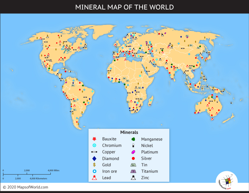
As you can see in the image above, the Middle East produces mainly oil, but also produces copper, lead, zinc, and iron, and a small amount of uranium, diamond, and bauxite.
Rocks
Oil is a major natural resources in the Middle East. In the oceans and seas near and aroung the Middle East, there are some ancient coral reefs made up of organic sedimentary rocks. The sediments of many dead plants and animals gather at the bottom of these seas and oceans to form the ancient coral reefs. These reefs are major sources of oil, as well. In fact, over 70% of the oil mined in the Middle East comes from the reefs.
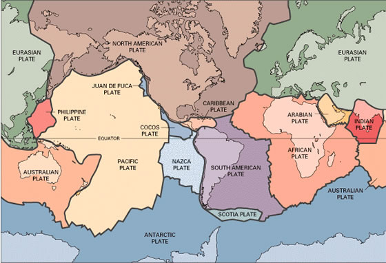
Plate Tectonics
The nearest plates to the middle east are the Arabian Plate, Indian Plate, and the Eurasian Plate.
The latitude boundary of the Arabian Plate 35 degrees North to 15 degrees North.
The longitude boundary is 35 degrees East to 55 degrees East.
The Northern Arabian sea contains the Makran Subduction Zone, which caused a famous tsunami and earthquake on November 28, 1945
The continental margin of Saudi Arabia is active. The border of Iran, Azerbaijan, and Georgia is where the Arabian Plate meets the Eurasian Plate. There are volcanoes and earthquakes here. This info is found at our google earth link.
Volcanoes
The Middle East has many volcanoes. These volcanoes are mainly located on the western edge.
They are mainly basaltic volcanoes that are cinder cones.
There have been no large eruptions that have historical significance. No major volcanoes were near large civilizations because many of the people were nomadic.
Earthquakes
There have been very few earthquakes in the Middle East.
The few that there have been are all in the northwestern tip next to the Gulf of Aqaba.
The major earthquakes in the last 20 years have the magnitudes of 7.3 and 6.1. Other than those, there are no major have been no major earth quakes.
References
http://www.mideastweb.org/countries.htm http://www.state.gov http://koeppen-geiger.vu-wien.ac.at/present.htm http://www.worldatlas.com/webimage/countrys/asia/tj.htm http://www.countriesquest.com/middle_east/iran/land_and_resources/natural_regions.htm http://www.magazine.noaa.gov/stories/mag87.htm https://www.cia.gov/library/publications/the-world-factbook/fields/2111.html Cia website : https://www.cia.gov/library/publications/the-world-factbook/geos/af.html http://econgeol.geoscienceworld.org/content/74/2/484.abstract http://www.state.gov/r/pa/ei/bgn/5755.htm http://bishkek.usembassy.gov/uploads/images/lzXO-ytUAKSiRn8QQojRTg/KG_07_Mining_Report.pdf http://www.indexmundi.com/oman/natural_resources.html http://www.indexmundi.com/oman/natural_resources.html http://www.state.gov/r/pa/ei/bgn/3453.htm http://www.state.gov/r/pa/ei/bgn/3453.htm http://www.slb.com/~/media/Files/resources/mearr/wer15/rel_pub_mewer15_1.ashx http://www.mapsofworld.com/syria/economy/industry.html http://www.saudiembassy.net/about/country-information/energy/minerals_and_mining.aspx http://countrystudies.us/turkey/66.htm http://www.state.gov/r/pa/ei/bgn/3432.htm http://www.state.gov/r/pa/ei/bgn/5444.htm http://www.uaeinteract.com/uaeint_misc/pdf/perspectives/12.pdf http://www.indexmundi.com/tajikistan/natural_resources.html http://www.state.gov/r/pa/ei/bgn/2924.htm http://www.tashkent.org/uzland/economy.html