Earth Science 7 - Russia, China, and Japan - 8
Link to Earth Science 7-Regions Page: Earth Science 7-Regions
Contents
- 1 Russia
- 1.1 Countries in Russia
- 1.2 Latitude and Longitude Ranges
- 1.3 Elevation Range
- 1.4 Large Bodies Of Water
- 1.5 Major Topographic Features
- 1.6 Bordering Oceans
- 1.7 Climate (using Koppen Scale)
- 1.8 Monthly Highs and Lows
- 1.9 Average Monthly Rainfall
- 1.10 Average Precipitation
- 1.11 How These Things Affect Russia's Climate
- 1.12 Geology
- 1.13 Tectonic Plates
- 2 China
- 2.1 Countries in China
- 2.2 Latitude and Longitude Ranges
- 2.3 Elevation Range
- 2.4 Large Bodies of Water
- 2.5 Major Topographic Features
- 2.6 Bordering Oceans
- 2.7 Climate (using Koppen Scale)
- 2.8 Monthly Highs and Lows
- 2.9 Average Monthly Rainfall
- 2.10 Average Precipitaion
- 2.11 How These Things Affect China's Climate
- 2.12 Geology
- 2.13 Tectonic Plates
- 3 Japan
- 3.1 Countries in Japan
- 3.2 Latitude and Longitude Ranges
- 3.3 Elevation Range
- 3.4 Large Bodies Of Water
- 3.5 Major Topographic Features
- 3.6 Bordering Oceans
- 3.7 Climate (using Koppen Scale)
- 3.8 Monthly Highs and Lows
- 3.9 Average Monthly Rainfall
- 3.10 Average Precipitation
- 3.11 How These Things Affect Japan's Climate
- 3.12 Geology
- 3.13 Tectonic Plates
- 4 Links
Russia
Countries in Russia
Russia is a single country.
Latitude and Longitude Ranges
Latitude: about 50 degrees North to about 75 degrees North [1]
Longitude: about 28 degrees East to about 160 degrees West [1]
Elevation Range
The range is 5,661 meters from the highest spot to the lowest spot.[2]
- Highest Spot: Mt. Elbrus = 5,633 meters[2]
- Lowest Spot: Caspian Sea = -28 meters[2]
Large Bodies Of Water
Rivers: There are over 100,000 rivers with a length of 7 miles or greater, and even more streams, brooks, creeks, etc. [1]
Major rivers:
- Volga [1]
- Dnieper [1]
- Dvina [1]
- Lena [1]
- Ob [1]
- Yenisey [1]
- Amur [1]
Major Lakes: Lake Baikal is the deepest lake in the world (1,620 meters). [1]
Major Topographic Features
- Ural Mountain Range [1]
- The broad European Plain extends from the Ural Mountains to its western borders with Europe. [1]
- The Caucasus Mountains include the country's highest point, Mt. Elbrus. [1]
- The Central and Southern areas include large fertile areas, marsh, steppes (plains without trees) and massive coniferous forests. [1]
- A few mountain ranges on the Kamchatka Peninsula contain active volcanoes.[1]
Bordering Oceans
- Arctic Ocean [2]
- North Pacific Ocean[2]
Climate (using Koppen Scale)
Almost all of Russia is Dfc, the most common subarctic climate. Locations in the Dfc area, such as Siberia, have cold, long winters and brief cool summers. In addition, Russia includes similar zones, such as Dfd, Dwd, and Dwc. Russia also has Dfb, which means humid continental climate, hot summer, cold winters. An example of this climate is Russia's capital, Moscow. [3]
Monthly Highs and Lows
- January- High: 24°, Low: 17°[4]
- February- High: 25°, Low: 16°[4]
- March- High: 36°, Low: 24°[4]
- April- High: 51°, Low: 36°[4]
- May- High: 65°, Low: 46°[4]
- June- High: 71°, Low: 54°[4]
- July- High: 75°, Low: 58°[4]
- August- High: 71°, Low: 54°[4]
- September- High: 60, Low: 46°[4]
- October- High: 47°, Low: 37°[4]
- November- High: 32°, Low: 26°[4]
- December- High: 25°, Low: 18°[4]
Average Monthly Rainfall
- January- 1.57 in[4]
- February- 1.28 in[4]
- March- 1.07 in[4]
- April- 0.95 in[4]
- May- 1.54 in[4]
- June- 2.33 in[4]
- July- 2.19 in[4]
- August- 2.22 in[4]
- September- 1.81 in[4]
- October- 1.96 in[4]
- November- 1.5 in[4]
- December- 1.41 in[4]
Average Precipitation
- January- 1.7 in[5]
- February- 1.4 in[5]
- March- 1.3 in[5]
- April- 1.7 in[5]
- May- 2 in[5]
- June- 3 in[5]
- July- 3.7 in[5]
- August- 3 in[5]
- September- 2.6 in[5]
- October- 2.3 in[5]
- November- 2.3 in[5]
- December- 2.2 in[5]
How These Things Affect Russia's Climate
Latitude: The latitude of Russia affects the climate because it is near the North Pole. This basically means that Russia's climate is mainly cold.
Elevation:In Russia, high elevation places (such as Mount Elbrus, a tall mountain) is cold because air at higher points is less dense, therefore holding less heat. In addition, temperature decreases with altitude, so Mount Everest would be extremely cold because of its high altitude. The Caspian Sea, a low elevation point, is going to be warmer because air at lower points is denser and therefore holds more heat.[6]
Topography: Mountain ranges, like the Ural Mountain Range, can act as barriers to wind and rainfall, so areas on the leeward side of mountains (such as Chelyabinsk[7]) will have drier climates. The Ural Mountains can have a cooler temperature because temperature decreases with altitude. [6]
Proximity to Water: Climate is also changed by Russian locations’ proximity to water. Locations near water such as: Rostov-Na-Donu, Sochi, and Astrakhan have a higher precipitation level than places farther away from water such as: Surgat, Tomsk, and Nizhniy Tagil.[8]
Prevailing Winds: Prevailing winds can also change climate. Prevailing winds can change water’s surface temperature which can easily change the temperature of cities on the coast such as Okhotsk, Maykhop, and Tumany.
Vegetation: Vegetation also changes the climate. Places with forests such as Pechora Ylych will warm slower than places with meadows or no trees which warm quickly.
Russia is a High/Low Pressure Zone: High and low pressure zones also affect climate. In winter an intense high pressure system causes winds to blow from the south and southwest and in the summer a low-pressure system brings winds from the north and northwest. High pressure zones tend to have sunny weather while low pressure zones mostly have cloud, rainy weather. Since wind flows from a high pressure area to a low pressure zone if there is a high and low next to each other the location would be extremely windy.
Ocean Currents: Ocean currents play a part in affecting climate as well. The North Equatorial Warm Current and the Kuroshio Warm Current would warm up cities such as: Moroshechnoye, Kronoki, and Ust' Tigil. The Oyashio Cold Current would cool off cities such as: Kavacha, Paknachi, and Khatyrka.[8]
Geology
Mining Resources
- Coal[9]
- Tin[9]
- Bauxite[9]
The most important regions for mining are Siberia (particularly East Siberia), the Kola Peninsula, the North Caucasus, and the Urals. [9]
Minerals
- Gold[9]
- Diamonds[9]
- Silver[9]
- Iron[9]
- Lead[9]
- Copper[9]
- Mica[9]
- Talc[9]
- Zinc[9]
About half of Russia’s mineral resources are east of the Urals. [9]
Rock Types
- Near the Sea of Okhotsk and Lake Baikal would be sedimentary rocks because water deposits the sediments that later compact and cement together to form sedimentary rocks.[10]
- Near the Ural Mountains there would be many metamorphic rocks because of heat and pressure (from mountain-building).[10]
- Near the Bezymianny Volcano, which last erupted in 2011, there would be lots of igneous rocks due to the cooling of lava.[10]
Tectonic Plates
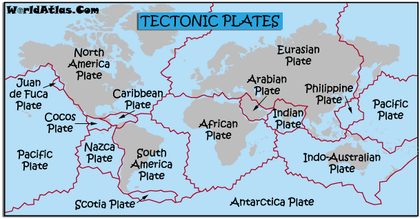
Most of Russia is located on the Eurasian Tectonic Plate, but eastern Russia is on the North American Plate. The exact boundary between the two plates is uncertain. The Pacific Plate is located off of Russia's eastern coastline. The movement of these three plates against each other is a cause of significant earthquakes and volcanoes in this region, especially on Kamchatka. Seismic activity is also common in the Caucasus Mountains in the southwest.[11]
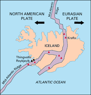
The Mid-Atlantic Ridge separates the Eurasian and North American plates, and it is a divergent boundary.[12]
 [12]'
[12]'
The collision of India into Asia 50 million years ago caused the Eurasian Plate to crumple up and override the Indian Plate. After the collision, the slow continuous convergence of the two plates over millions of years pushed up the Himalayas and the Tibetan Plateau to their present heights. Most of this growth occurred during the past 10 million years.[12]

Between the Eurasian Plate and the Philippine Plate is a convergent boundary. Between the Eurasian Plate and the Indian Plate is a transform boundary and a convergent boundary. Between the Pacific Plate and the Eurasian Plate is a convergent boundary. (Learned from textbook)
The Urals of Central Russia are evidence of ancient continental collision margins.[13]
Most volcanoes in the region of Kamchatka and Kuril Islands, but there are some in other parts of Russia. [14]
There is an active continental margin in Southeast Russia. [15]
Volcanoes
Russia has many volcanoes. Most of the volcanoes are composite volcanoes (andesitic magma), but some are cinder cones (rhyolitic magma). Almost all of the volcanoes were formed on the subduction boundary where the Eurasian plate is the overriding plate.[16]
Asacha is in the southern part of the Kamchatka Peninsula in far east Russia. Avachinsky is in the far eastern part of the Kamchatka Peninsula in far east Russia. Bezymianny is in the southeastern part of the Kamchatka Peninsula in far east Russia. Bolshoi Semiachik is in the central part of the Kamchatka Peninsula in far east Russia. Diky Greben is in the southern part of the Kamtcha Peninsula in far east Russia. Elbrus is in the western part of the Kamchatka Peninsula in far east Russia. Gamchen is in the southeastern part of the Kamchatka Peninsula in far east Russia. Gorely is in the southern part of the Kamchatka Peninsula in far east Russia. Ilynisky is in the southern part of the Kamchatka Peninsula in far east Russia. Ipelka is in the southern part of the Kamchatka Peninsula in far east Russia. Kambalny is in the southern part of the Kamchatka Peninsula in far east Russia. Kell is in the southern part of the Kamchatka Peninsula in far east Russia. Khodutka is in the southern part of the Kamchatka Peninsula in far east Russia. Karymsky is in the eastern part of the Kamchatka Peninsula in far east Russia. Kikhpinych is in the eastern part of the Kamchatka Peninsula in far east Russia. Koryaksky is in the eastern part of the Kamchatka Peninsula in far east Russia. Koshelev is in the southern part of the Kamchatka Peninsula in far east Russia. Krasheninnikov is in the eastern part of the Kamchatka Peninsula in far east Russia. Kronotsky is in the eastern part of the Kamchatka Peninsula in far east Russia. Ksudach is in the southern part of the Kamchatka Peninsula in far east Russia. Kliuchevskoi is in the eastern part of the Kamchatka Peninsula in far east Russia. Maly Semiachik is in the eastern part of the Kamchatka Peninsula in far east Russia. Mashkovtsev is in the southern part of the Kamchatka Peninsula in far east Russia. Mutnovsky is in the southern part of the Kamchatka Peninsula in far east Russia. Opala is in the southern part of the Kamchatka Peninsula in far east Russia. Paushetka is in the eastern part of the Kamchatka Peninsula in far east Russia. Sheveluch is in the northern part of the Kamchatka Peninsula in far east Russia. Soboliny is in the eastern part of the Kamchatka Peninsula in far east Russia. Tolbachik is in the southern part of the Kamchatka Peninsula in far east Russia. Udina is in the central part of the Kamchatka Peninsula in far east Russia. Uzon is in the eastern part of the Kamchatka Peninsula in far east Russia. Vilyuchik is in the southern part of the Kamchatka Peninsula in far east Russia. Zhelotovsky is in the western part of the Kamchatka Peninsula in far east Russia. Zhupanovsky is in the southeastern part of the Kamchatka Peninsula in far east Russia. Zimina is in the central part of the Kamchatka Peninsula in far east Russia. [16]
There have been recent (from 1996 to 2009) major eruptions that have historical significance. These include:
- Akademia Nauk-1996[17]
- Avachinsky-2001[17]
- Bezymianny-2011[17]
- Gorely-2010[17]
- Karymsky-2010[17]
- Kizimen-2011[17]
- Klyuchevskaya Sopka-2010[17]
- Koryaksky-2008[17]
- Mutnovsky-2000[17]
- Shiveluch-2010[17]
- Chikurachki-2005[17]
- Ebeko-2005[17]
- Sarychev Peak-2009[17]
Earthquakes
Russia has many earthquakes. These tend to occur at the convergent (subduction) boundaries and at fault areas. In a geographical sense, earthquakes occur mostly on the eastern coasts of Russia. [18]
Some recent (2000-present) earthquakes that have occurred (over M 6) include:
- 11/17/2002-Kuril Islands, Russia - M 7.3[19]
- 7/27/2003-Primor'ye, Russia - M 6.8[19]
- 9/27/2003-Southwestern Siberia, Russia - M 7.3[19]
- 10/1/2003-Southwestern Siberia, Russia - M 6.7[19]
- 12/5/2003-Komandorskiye Ostrova, Russia Region - M 6.7[19]
- 6/10/2004-Kamchatka Peninsula, Russia - M 6.9[19]
- 4/20/2006-Koryakia, Russia - M 7.6[19]
- 11/15/2006-Kuril Islands - M 8.3[19]
- 1/13/2007-East of the Kuril Islands - M 8.1[19]
- 4/7/2009-Kuril Islands - M 6.9[19]
- 4/18/2009-Kuril Islands - M 6.6[19]
Some especially significant (over M 8) earthquakes in Russia's history include:
- 2/3/1923-Kamchatka-M 8.5[19]
- 11/4/1952-Kamchatka-M 9.0[19]
- 11/6/1958-Kuril Islands-M 8.3[19]
- 10/13/1963-Kuril Islands-M 8.5[19]
- 11/15/2006-Kuril Islands - M 8.3[19]
- 1/13/2007-East of the Kuril Islands - M 8.1[19]
China
Countries in China
China is a single country.
Latitude and Longitude Ranges
Approximate latitude: 18°15′N to 53°30′N [20]
Approximate longitude: 74°E to 134°30′°E[20]
Coordinates of its capital, Beijing:[20]
Latitude: 39°54′50″N [20]
Longitude: 116°23′30″E [20]
Elevation Range
Highest Spot: The highest point in China is Mount Everest. It is 8848.13 m high. They are between Nepal and China, but we can say that it is the highest mountain in China. [1]
Lowest Spot: Turpan Pendi (the Turpan Depression) 700 meters[20]
Large Bodies of Water
Major Rivers:
- Hong Ze Hu[20]
Major Topographic Features
Volcanoes:
- Baekdu Mountain[20]
- Honggeertu[20]
- Holocene Jingbo[20]
- Keluo Group[20]
- Holocene Kunlun Volcanoes[20]
- Leizhou Bandao[20]
- Holocene Longgang Group[20]
- Tengchong[20]
- Tianshan Volcanic Group[20]
- Turpan[20]
- Holocene Wudalianchi[20]
Mountains:
- Tai Shan[20]
- Heng Shan Bei[20]
- Hua Shan[20]
- Heng Shan Nan[20]
- Song Shan[20]
Bordering Oceans
The Pacific Ocean,the Mediterranean Sea, and the China Sea border China.[20]
Climate (using Koppen Scale)
Using the Koppen Climate Scale, the climate is very arid and dry and humid subtropical in the country china. China's Year Average Temperature 11.8 °C, Year Average High Temperature 17.5 °C, Year Average Low Temperature 6.1 °C. The average annual rainfall 578 mm[2] [3]
Monthly Highs and Lows
January high:35 lows:15
Febuary high: 39 lows:20 [4]
March high: 52 lows:31 [5]
April high: 68 lows:45 [6]
May high: 80 lows: 56 [7]
June high:87 lows:: 65 [8]
July high: 87 lows:71 [9]
August high: 85 lows:69 [10]
September high:78 lows:58 [11]
October high: 66 lows:45 [12]
November high: 50 lows:31 [13]
December high: 38 lows:20 [14]
Average Monthly Rainfall
January- 3.0 (mm)[15]
Febuary- 7.4 (mm)[16]
March- 8.6 (mm)[17]
April- 19.4 (mm)[18]
May - 33.1 (mm)[19]
June- 77.8 (mm)[20]
July- 192.5 (mm)[21]
August- 212.3 (mm)[22]
September- 57.0 (mm)[23]
October- 24.0 (mm)[24]
November- 6.6 (mm)[25]
December- 2.6(mm)[26]
Average Precipitaion
China's precipitation varies from an average of 394 mm (15.5 in) in July to only 31 mm (1.2 in) in December. The greatest rainfall and highest relative humidity occur in the southeast coastal regions, which receive an annual rainfall in excess of 1,000 mm (39.4 in).[27]
How These Things Affect China's Climate
Latitude: The climate in China is extremely diverse due to its wide coverage, assortment of terrains as well as the different distances to the sea from different locations. The tremendous differences in latitude, longitude, and altitude cause much variation in precipitation and temperature within China, which combine to make the climate in China climate very complex. Most of China lies in the temperate belt, with its south in subtropical belt and north in subarctic belt. Climates vary a lot from region to region because of the country's extensive territory and complex landscapeIn most parts of China, summer coincides with much rainfall and winter coincides with little rainfall due to the influence of the southeast monsoon. However, in northeast China summer is short, with mostly sunshine as it is less cloudy, while winter is long and cold. The cold temperature within the northwest of China, mean rainfall is limited.
Elevation: The higher in altitude the colder the temperature. Temp. drop 4°F every 1000 feet. That means that 75° at the bottom and 10000 feet up it will be 35°. This colder temp does affect plant growth but it also affects the soil which in turn affects plant growth. Mountain vegetation (depending on the elevation) is comparable to the vegetation in areas of high latitude. Areas found up in the northern regions are affected by the colder temp as are the soils - same happens in mountainous areas.
You tend to see more evergreens and soils are more acidic and less rich (poor nutrients). You will also get your permafrosts. Eventually a treeline occurs - mountain tops become treeless as does the north arctic areas. You find mosses growing in and around the rocks with some shrubs whereever there is enough soil for the roots to take.
"An increase in altitude, such as climbing a mountain is similar to heading north (in the northern hemisphere) plant and animal species will be similar at a mountain top to those which are further north. " [28]
Topography: The territory of modern China is characterized by dramatic geographical diversity. Topographically, it is low in the east and high in the west. The land surface ascends like a three-step staircase. The plains and lowlands in the east and southeast constitute the first step, occupying about 12 percent of the land. Two-thirds of the country, the two higher steps, are mostly mountains and high plateaus. [29]
Proximity to Water; one way a climate is affected by the proximity (closeness) of water , is that it raises the precipitation level and makes it relatively high compared to a continental climate. The Yangtze River is already one of the most polluted rivers in the world. Because of it’s proximity to several city centers, the dumping of industrial wastEnter away message text here.e and sewage has always been a serious problem. More than 265 billion gallons of raw sewage are dumped into the Yangtze annually. In addition, the reservoir itself flooded 1,600 abandoned factories, mines, dumps, and potential toxic waste sites. So basically it effects it alot because it goes to places where people work.
Prevailing Winds: The prevailing winds blow across southern China from the southeast. Further north they blow in from the west. Cold air pours down from Siberia in the winter. Warm air comes up from Southeast Asia and the South China Sea in the summer. There are often vicious storms, heavy rains, floods and landslides in the early summer.
Seasonal monsoon winds do not influence China as much as other Asian countries. However the early summer is the peak rainy season in much of China. Seasonal rain fall is often unpredictable, resulting in droughts and floods. Cyclonic storms sometimes approach from Europe. Typhoons strike from time to time, particularly along the southeast coast, in late summer and early fall. [30]
Vegetation: Generally speaking, plants are adapted to the climate in which they live. Just as plants have their own optimum temperature range they also have an optimum climate. Desert plants are adapted to a hot dry sunny climate whereas plants in northern China are adapted to survive hot sunny summers as well as freezing snowy winters. Adaptations include thick waxy leaves to reduce moisture loss or dropping leaves and entering a state of dormancy to survive freezing temperatures. Learn more about specific adaptations of alpine plant.
China is a High/Low Pressure Zone:China is the largest producer of greenhouse gases and the largest emitter of carbon dioxide. It was not supposed to overtake the United States as the world’s leading producer of greenhouse gases until 2020 but a study by a Dutch government-funded group released in June 2007 determined that China was already the world’s No. 1 emitter of carbon dioxide then. It surpassed the United States in 2006 when it produced 7.5 percent more of these gasses than the United States compared to 2 percent less in 2005. In August 2008, Germany’s IWR Institute concluded that China’s carbon dioxide emissions in 2008 were 6.8 million tons—the most of any nation and 178 percent higher than the 1990 level. The United States and China together account for 40 percent of the world's greenhouse gases, most of which is derived from coal. [31]
Ocean Currents: Fossil evidence and computer models demonstrate that Earth’s complex and dynamic climate system has more than one mode of operation. Each mode produces different climate patterns. The evidence also shows that Earth’s climate system has sensitive thresholds. Pushed past a threshold, the system can jump quickly from one stable operating mode to a completely different one—“just as the slowly increasing pressure of a finger eventually flips a switch and turns on a light,” the NAS report said. Scientists have so far identified only one viable mechanism to induce large, global, abrupt climate changes: a swift reorganization of the ocean currents circulating around the earth. These currents, collectively known as the Ocean Conveyor, distribute vast quantities of heat around our planet, and thus play a fundamental role in governing Earth’s climate.
Geology
Mining Resources
- Oil[21]
- Natural Gas[21]
- Coal[21]
- Uranium[21]
Minerals
Almost all of the world's known minerals can be found in China. As of 2004, geologists have confirmed reserves of 158 different minerals.[21] Some of these include:
- Iron Ores (such as hematite)[21]
- Manganese[21]
- Copper[21]
- Aluminum[21]
- Lead (or galena)[21]
- Zinc[21]
- Graphite[21]
- Sulfur[21]
Rock Types
- At Mount Kailash, a mountain in the Gangdise Mountains, metamorphic rock such as metaconglomerate is formed by the process of mountain building. [22]
- Mount Heishan (1,422 meters above sea level), the tallest volcano in the Datong Volcanoes, creates igneous rock like scoria and pumice when it erupts.[23]
- When rivers like the Indus River deposit sediments, they get cemented and/or compacted to form sedimentary rocks like limestone.[22]

Tectonic Plates
China lies on the Eurasian and Indian Plates.[24]
Betweeen the eurasion and north american plate is a divergent boundary. As North America moves westward and Eurasia eastward, new crust is created on both sides of the diverging boundary. [32]
Between the Eurasian Plate and the Indian Plate is a transform boundary and a convergent boundary. Between the Pacific Plate and the Eurasian Plate is a convergent boundary. (learned from text book)
Between the Eurasian Plate and the Philippine Plate is a convergent boundary. Between the Eurasian Plate and the Indian Plate is a transform boundary and a convergent boundary. Between the Pacific Plate and the Eurasian Plate is a convergent boundary. (Learned from textbook)
Volcanoes
China has many volcanoes. They are located in northern China and in the eastern part of China. They are mostly cinder cones. .
There have been major eruptions that have historical significance.
The Changbai Mountains separate China from North Korea, and Baekdu (or Changbai) Mountain stands as the tallest of the range. An active volcano with a lake in its caldera, the most recent eruption came in 1903. [25]
There arent a butload of histric eruptions in china but there are a few:
- Tengchong-1609[33]
- Wudalianchi-1776
- Changbai Mountain-1903
- Kunlun Volcanoes-1951
- Turpan- 1120
Earthquakes
China has many earthquakes. These tend to occur in (LOCATION).
Some recent earthquakes that have occurred:
The most destructive earthquakes of the 20th Century were those of 1927 in Tsinghai, of 1932 in Gansu, of 1933 in Sichuan, of 1969 in Bohai Sea, of 1970 in Tonghai (Yunnan), of 1974 in Zhaotong (Yunnan), of 1975 in Haicheng, and of 1976 in Tangshan (Hebei Province) . The more recent earthquake of May 12, 2008 in Sichuan Province was the latest of the more destructive earthquakes that have struck China in the new millennium
China tends to have more earthquakes than volcanoes.
Some especially significant earthquakes in China's history include:
- Jan. 23, Shaanxi (Shensi) province, China: most deadly earthquake in history in china
- 1920 Dec. 16, Gansu province, China: magnitude 7.8 earthquake killed 200,000 in northwest China
- 1927 May 22, nr. Xining, China: magnitude 7.9 earthquake claimed approximately 200,000 victims. 1932 Dec. 25, Gansu, China: magnitude 7.6 earthquake killed approximately 70,000.
- 1970 Jan. 5, Yunnan province, China: magnitude 7.5 quake killed more than 10,000. May 31, Peru: magnitude 7.9 earthquake left more than 66,000 dead.
- July 28, Tangshan, China: worst earthquake to hit China in 20th century; devastated 20 sq mi of city, leaving 255,000 (official) dead. Estimated toll as high as 655,000.
- May 12,2008 China: over 67,000 people die and hundreds of thousands more are injured when a 7.9 magnitude earthquake strikes Sichuan, Gansu, and Yunnan Provinces in western China. Nearly 900 students were trapped when Juyuan Middle School in the Sichuan Province collapsed from the quake.[ http://www.infoplease.com/ipa/A0001439.html#ixzz1ta2YCIRv]
Japan
Countries in Japan
Although it is a chain of islands, Japan is a single country.
Latitude and Longitude Ranges
- Latitude Range: about 24 degrees North to 44 degrees North[1]
- Longitude Range about 123 degrees East to 145 degrees East[1]
Elevation Range
Highest Spot: Fujiyama(3,776 meters)[2]
Lowest Spot: Hachiro-gata (-4 meters)[2]
Large Bodies Of Water
- Sea of Japan [2]
- Philippine Sea[2]
- East China Sea[2]
Major Topographic Features
Volcanoes:
- Aso[2]
- Bandai[2]
- Fuji[2]
- Iwo-Jima[2]
- Kikai[2]
- Kirishima[2]
- Unzen[2]
- Sakura-jima[2]
- AsamaKomaga-take[2]
- Oshima [2]
- Suwanosejima[2]
- Tokachi[2]
- Yake-dake[2]
- Usu[2]
Japan contains four main islands (Hokkaido, Honshu, Shikoku, and Kyushu) and numerous smaller islands to the north and south, all prone to earthquakes. [26]
Bordering Oceans
- North Pacific Ocean[2]
Climate (using Koppen Scale)
Japan contains the Cwa, Dfa, and Dfb zones.
- Cwa: Humid, onshore movement in summer, cyclonic storms in winter [27]
- Dfa: Humid continental hot summers with year-round precipitation [27]
- Dfb: Humid continental mild summer with year round rainfall [27]
Monthly Highs and Lows
Average temperature of Aomori, a city in Dfa zone:
- January - High: 34, Low: -23
- February - High: 35, Low: 22
- March - High: 41, Low: 27
- April - High: 55, Low: 36
- May - High: 65, Low: 46
- June - High: 70, Low: 55
- July - High: 77, Low: 63
- August - High: 81, Low:66
- September - High: 63, Low: 44
- October - High: 73, Low: 57
- November - High: 51, Low: 35
- December - High: 39, Low: 28
Average temperatures of Asahikawa (Dfb):
- January - High: 24, Low:7
- February - High: 26, Low: 8
- March - High: 35, Low: 18
- April - High: 50, Low: 31
- May - High: 64, Low: 42
- June - High: 72, Low: 52
- July - High: 78, Low: 60
- August - High: 79, Low: 61
- September - High: 70, Low: 50
- October - High: 57, Low: 38
- November - High: 42, Low: 28
- December - High: 30, Low: 17
Average Monthly Rainfall
- January - 1.91 in
- February - 2.37 in
- March - 4.51 in
- April - 5.13 in
- May - 5.04 in
- June - 6.49 in
- July - 6.36 in
- August - 6.11 in
- September - 8.21 in
- October - 6.42 in
- November - 3.64 in
- December - 1.56 in
Average Precipitation
- January - 2.9 in
- February - 2 in
- March - 2 in
- April - 2 in
- May - 2.6 in
- June - 2.8 in
- July - 3.8 in
- August - 6.3 in
- September - 5.2 in
- October - 4.4 in
- November - 4.6 in
- December - 3.7 in
How These Things Affect Japan's Climate
Latitude: Japan’s latitude is located in the temperate zone, a very similar latitude to that of Eastern United States. Because this country is in the temperate zone, the temperatures in this zone are usually warm and mild with a plentiful amount of precipitation. [28]
Elevation: Japan ranges in elevation from 500 feet, to around 5,000 feet. Due to the fact that temperature drops steadily as elevation increases in an area, the areas closer to sea level, like the Sea of Japan and Hachiro-gata, it is generally warmer than those at at a much higher elevation, like Mount Fuji, which is located on the border of Shizuoka and Yamanashi prefectures, where temperatures are extremely low and snow found almost year round. [29]
Topography: Japan is covered by rugged mountains that occupy 3/4 of the entire country. On these mountains, because of the high elevation, precipitation is common and temperatures are colder. Once past a mountain, the air tends to be less saturated, and the land is dry and arid. [29]
Proximity to Water; Japan is a archipelago of islands completely surrounded by water, which brings countless days filled with rain due to the evaporation of the ocean water, lots of typhoons (5-6 a year), and a large number of dangerous hurricanes.[30]
Prevailing Winds: In winter months, prevailing winds coming from the northwest provide large amounts of rainfall in cities such as Niigata, on the western side of Japan. In summer months, prevailing winds coming from the southeast lead to great amounts of rain in eastern cities, such as Tokyo.[31]
Vegetation: Since the maritime location and tropical climate brings steady amounts of rain and constant humidity to the country, rice, an essential food staple in many Asian countries, is one of Japan's most important economic link to the rest of the world.[28]
Japan is a High/Low Pressure Zone: Japan is a low pressure system. A low pressure zone is basically a system where the air is warmer and less dense, and prevailing winds blow from different countries into the system. Characteristics included in Japan's low pressure zone are a hot, humid climate with constant and steady rainfall.
Ocean Currents: Two major ocean currents affect this climatic pattern: the warm Kuroshio Current (Black Current; also known as the Japan Current); and the cold Oyashio Current (Parent Current; also known as the Okhotsk Current). The Kuroshio Current flows northward on the Pacific side of Japan and warms areas as far north as Tokyo. The Oyashio Current, which abounds in plankton beneficial to coldwater fish, flows southward along the northern Pacific, cooling adjacent coastal areas. The meeting point of these currents at 36 north latitude is a bountiful fishing ground.. [30]
Geology
Mining Resources
- Japan is the world's largest importer of coal and liquefied natural gas. [32]
- Japan is the second largest importer of oil.[32]
- Coal [33]
Minerals
- Iron ores (such as hematite)[33]
- Copper[33]
- Lead (or galena)[33]
- Zinc
Rock Types
- Because Japan is mostly rugged and mountainous, you would expect to find mostly metamorphic rocks. This is the reason that Japan is the world’s largest exporter of coal, a metamorphic rock.[34]
- Japan does not have many rivers, but where there are rivers, you can find sedimentary rocks. For example, by rivers such as the Kiso River, Yodo River, and Gouno River, you can find rocks such as shale. [35]

Tectonic Plates
Japan lies on the boundary of three tectonic plates: the Eurasian, the Pacific, and the Philippine plates.

These are all subduction boundaries, with the Pacific plate subducting under the Eurasian plate (creating the Marianas Trench), the Pacific plate subducting under the Philippine plate, and the Philippine plate subducting under the Eurasian plate.[37]

The east side of Japan is an active margin, while the west is passive. (learned from Ms. Gant).
The type of rock in the region is related to the tectonic activity. There is a lot of igneous rock in Japan due to the multiple volcanic eruptions that result in the formation of the rock. There is also lot sedimentary rock because Japan is an island, and many sediments that were deposited on the ocean floor turned into rock. After a long period of time, the subduction boundaries between the Pacific, Eurasian, and Philippine plates created a mountain range on the edge of Japan, and much of the rock was sedimentary. [38]
Volcanoes
You can find many volcanoes on the island of Japan. Almost all of these volcanoes are part of an arc, or a curved chain of volcanoes. Located on Japan are the Southwest Honshu Arc, the Northeast Honshu Arc, the Kurile Arc, and the Ryukyu Arc. As pictured, you may notice that there are volcanoes on the entire island of Japan, and they are typically found towards the middle of the island. The composite volcanoes in the country of Japan are composed of andesitic magma, the shield volcanoes are composed of basaltic magma, and the cinder cones on Japan are composed of rhyolitic magma. (Learned from textbook) These include:
- Adatara: Honshu[39]
- Akan: Hokkaido[39]
- Asahi: Hokkaido[39]
- Asama-yama: Honshu[39]
- Aso: Kumamoto[39]
- Azuma: Fukushima[39]
- Bandai: Fukushima[39]
- (Fuji: Honshu[39]
- Hakone: Honshu[39]
- Iwo-jima: Ogasawara Archipelago[39]
- Izu Volcanic Islands: Southeast of Honshu[39]
- Izu-Tobu: Eastern Izu peninsula[39]
- Kikai: Iojima[39]
- Kirishima: Kyushu[39]
- Komaga-take: Honshu[39]
- (Kusatsu-Shirane: Kusatsu[39]
- Kuttara: Hokkaido[39]
- Kuttyaro: Hokkaido[39]
- Nantai: Honshu[39]
- Nasu: Tochigi[39]
- Nikko-Shirane: Gumma[39]
- Nipesotsu-Upepesanke: Hokkaido[39]
- Oshima: Izu islands[39]
- Oyama: Miyakejima Island[39]
- Rausu: Hokkaido[39]
- Sakurajima: Kyushu[39]
- Shikotsu: Hokkaido[39]
- Shin-dake: Kyushu[39]
- Shiretoko-Iwo-Zan: Hokkaido[39]
- Showa-Shinzan: Hokkaido[39]
- Tokachi: Hokkaido[39]
- Tsurumi: Higashiyama[39]
- Unzen: Shimabara[39]
- Usu and Toya: Hokkaido[39]
- Yake-dake: Azumi[39]

Japan has shield volcanoes, composite volcanoes, and cinder cones. Some of Japan's volcanoes have calderas.
There have been recent major eruptions, including:
- Myojin (9/1952)[40]
- Aso (4/1953)[40]
- Aso (6/1958)[40]
- Tokachidake (6/1962)[40]
- Usu (1977-1978)[40]
- Aso (6-11/1979)[40]
- Miyakejima(10/1983)[40]
- Izu-Oshima (11/1986)[40]
- Tokachidake (12/1988)[40]
- Unzen (11/1990-2/1995)[40]
- Usu (3/2000-6/2001)[40]
- Miyakejima (6/2000)[40]
There have been many eruptions that are historically significant in Japan. These include:
- Komagatake- in the 1640 eruption, the summit collapsed and the avalanche entered the sea, creating a tsunami and killing 700 people. In the 1929 eruption, .38 cubic kilometers of ash fell.[41]
- Oshima-Eruption began November 15, 1986 and continued until the 23rd. At one point the lava fountain was as high as 1,600 meters. The total volume of products of the eruption is estimated to be 7,900 tons.[41]
Earthquakes
Japan has many earthquakes. However, the most devastating earthquakes in Japan tend to occur on the eastern side of the island (though they occur nearly everywhere in the country). This is due to the fact that the Pacific plate and Eurasian plate meet at the east side of Japan. Because it is a subduction boundary, earthquakes tend to occur very often.[42]
Some recent (over 6.5, since 2000) earthquakes that have occurred include:
2001 - Geiyo earthquake: March 24, 2001[43]
2003 - Hokkaido earthquake: September 25, 2003[43]
2004 - Chuetsu earthquake: October 23, 2004[43]
2005 - Fukuoka earthquake: March 20, 2005[43]
2005 - Miyagi earthquake: August 16, 2005[43]
2006 - Kuril Islands earthquake: November 15, 2006[43]
2007 - Kuril Islands earthquake: January 13, 2007[43] Noto Peninsula earthquake: March 25, 2007[43] Chuetsu Offshore earthquake: July 16, 2007[43]
2008 - Iwate-Miyagi Nairiku earthquake: June 14, 2008 [43]
2009 - Izu Islands earthquake: August 9, 2009[43] Tokai Area earthquake: August 11, 2009[43]
2010 - Ryukyu Islands earthquake: February 26, 2010[43] Bonin Islands earthquake: December 21, 2010[43]
2011 - Tohoku earthquake: March 11, 2011[43]
2012 - Iza Islands, Japan: January 1, 2012[43]
Some especially significant earthquakes in Japan's history (over 7, since 1890) include:
- Mino-Owari, Japan (October 27, 1891): 8.0 [44]
- Kwanto, Japan (September 1, 1923) 8.3 [44]
- Tango, Japan (March 7, 1927) 7.6 [44]
- Sanriku, Japan (March 2, 1933) 8.4 [44]
- Tonankai, Japan (December 7, 1944) 8.1 [44]
- Nankaido, Japan (December 20, 1946) 8.1 [44]
- Kobe, Japan (January 17, 1995) 7.2 [44]
- Off the coast of Oshika Peninsula, the east coast of Tōhoku, Japan (March 11, 2011) 9.0[44]
Top 10 biggest/worst earthquakes in Japan:
10. Greant Kanto earthquake: September 1, 1923 - magnitude of 7.9, killed 142,800 [45]
9.Genroku earthquake: 1703 - magnitude of 8.0, killed 108,000[45]
8. Nankaido earthquake: Dec 20, 1946 - magnitude of 8.1, killed 1,362 [45]
7. Aomori earthquake: 1968 - magnitude of 8.2, killed 52[45]
6. Kuril Islands earthquake: 2006 - magnitude 8.4, killed no one[45]
5. Sanriku earthquake: 1933 - magnitude 8.4, killed 3,000[45]
4. Ansei-Nankai earthquake: 1854 - magnitude 8.4, killed 10,000 [45]
3. Meiji-Sanriku earthquake: 1896 - magnitude 8.5, killed 27,000[45]
2. Hoei earthquake: 1707 - magnitude 8.6, killed 5,000[45]
1. Tohoku earthquake: March 11, 2011 - magnitude 9.0, killed 29,000[45]
Links
- ↑ 1.00 1.01 1.02 1.03 1.04 1.05 1.06 1.07 1.08 1.09 1.10 1.11 1.12 1.13 1.14 1.15 1.16 1.17 http://www.worldatlas.com
- ↑ 2.00 2.01 2.02 2.03 2.04 2.05 2.06 2.07 2.08 2.09 2.10 2.11 2.12 2.13 2.14 2.15 2.16 2.17 2.18 2.19 2.20 2.21 2.22 2.23 2.24 https://www.cia.gov/library/publications/the-world-factbook/
- ↑ http://people.eng.unimelb.edu.au/mpeel/koppen.html
- ↑ 4.00 4.01 4.02 4.03 4.04 4.05 4.06 4.07 4.08 4.09 4.10 4.11 4.12 4.13 4.14 4.15 4.16 4.17 4.18 4.19 4.20 4.21 4.22 4.23 http://weather.uk.msn.com/monthly_averages.aspx?&wealocations=wc%3aRSXX0063&q=Moscow%2c+RUS&setunit=F
- ↑ 5.00 5.01 5.02 5.03 5.04 5.05 5.06 5.07 5.08 5.09 5.10 5.11 http://www.weather.com/weather/wxclimatology/monthly/graph/RSXX0063
- ↑ 6.0 6.1 http://www.rmets.org/activities/schools/local_winds.php
- ↑ http://www.elenastravel.com/cgi-bin/view.cgi?action=offers
- ↑ 8.0 8.1 http://www.aip.org/history/climate/oceans.htm
- ↑ 9.00 9.01 9.02 9.03 9.04 9.05 9.06 9.07 9.08 9.09 9.10 9.11 9.12 9.13 http://www.nationsencyclopedia.com/Europe/Russia-MINING.html#b
- ↑ 10.0 10.1 10.2 http://www.volcano.si.edu/world/
- ↑ http://www.nationsencyclopedia.com/geography/Morocco-to-Slovakia/Russia.html
- ↑ 12.0 12.1 12.2 12.3 http://www.platetectonics.com/book/page_5.asp
- ↑ http://www.tulane.edu/~sanelson/geol111/pltect.htm
- ↑ http://www.enotes.com/topic/List_of_volcanoes_in_Russia
- ↑ http://www.sciencedirect.com/science/article/pii/S0264817203000461
- ↑ 16.0 16.1 http://www.volcano.si.edu/world/volcano.cfm?vnum=1000-058
- ↑ 17.00 17.01 17.02 17.03 17.04 17.05 17.06 17.07 17.08 17.09 17.10 17.11 17.12 http://www.volcano.si.edu/world/
- ↑ http://www.bigsiteofamazingfacts.com/are-earthquakes-liable-to-happen-anywhere).
- ↑ 19.00 19.01 19.02 19.03 19.04 19.05 19.06 19.07 19.08 19.09 19.10 19.11 19.12 19.13 19.14 19.15 19.16 http://earthquake.usgs.gov/earthquakes/world/historical_country.php
- ↑ 20.00 20.01 20.02 20.03 20.04 20.05 20.06 20.07 20.08 20.09 20.10 20.11 20.12 20.13 20.14 20.15 20.16 20.17 20.18 20.19 20.20 20.21 20.22 20.23 http://www.noaa.gov
- ↑ 21.00 21.01 21.02 21.03 21.04 21.05 21.06 21.07 21.08 21.09 21.10 21.11 21.12 http://www.china.org.cn/english/features/China2004/106394.htm
- ↑ 22.0 22.1 22.2 http://www.shangri-la-river-expeditions.com/wchinageo/indushwgeo/kailash&indushwgeo.html
- ↑ http://scenery.cultural-china.com/en/113Scenery10574.html
- ↑
- ↑ http://forum.globaltimes.cn/forum/showthread.php?t=16178
- ↑ http://memory.loc.gov/cgi-bin/query/r?frd/cstdy:@field(DOCID+jp0005)
- ↑ 27.0 27.1 27.2 http://fairweatherfashion.wordpress.com/category/fashion-and-lifestyle/
- ↑ 28.0 28.1 http://afe.easia.columbia.edu/japan/japanworkbook/geography/japgeo.html
- ↑ 29.0 29.1 http://www.woodlands-junior.kent.sch.uk/Homework/mountains/climate.htm
- ↑ 30.0 30.1 http://www.photius.com/countries/japan/climate/japan_climate_climate.html
- ↑ 32.0 32.1 https://www.cia.gov/library/publications/the-world-factbook/fields/2111.html
- ↑ 33.0 33.1 33.2 33.3 33.4 http://maps.unomaha.edu/peterson/funda/MapLinks/Japan.htm
- ↑ https://www.cia.gov/library/publications/the-world-factbook/geos/ja.html
- ↑ 35.0 35.1 http://www.wepa-db.net/policies/state/japan/japan.htm
- ↑ 36.0 36.1 36.2 http://volcano.oregonstate.edu/vwdocs/volc_images/north_asia/japan_tec.html
- ↑ http://wiki.answers.com/Q/What_type_of_plate_boundary_is_Japan_on
- ↑ http://www.showcaves.com/english/jp/Geology.html
- ↑ 39.00 39.01 39.02 39.03 39.04 39.05 39.06 39.07 39.08 39.09 39.10 39.11 39.12 39.13 39.14 39.15 39.16 39.17 39.18 39.19 39.20 39.21 39.22 39.23 39.24 39.25 39.26 39.27 39.28 39.29 39.30 39.31 39.32 39.33 39.34 http://volcano.oregonstate.edu/vwdocs/volc_images/sorted_by_country.html
- ↑ 40.00 40.01 40.02 40.03 40.04 40.05 40.06 40.07 40.08 40.09 40.10 40.11 http://homepage3.nifty.com/hyamasat/eruption.html
- ↑ 41.0 41.1 http://www.pdc.org/iweb/volcano_deadliest1.jsp
- ↑ http://www.pnsn.org/news/articles
- ↑ 43.00 43.01 43.02 43.03 43.04 43.05 43.06 43.07 43.08 43.09 43.10 43.11 43.12 43.13 43.14 43.15 http://en.wikipedia.org/wiki/List_of_earthquakes_in_Japan
- ↑ 44.0 44.1 44.2 44.3 44.4 44.5 44.6 44.7 http://www.raptureready.com/time/rap31q.html
- ↑ 45.0 45.1 45.2 45.3 45.4 45.5 45.6 45.7 45.8 45.9 http://www.ouramazingplanet.com/1170-japan-earthquakes-top-10-110408.html