Earth Science 7 North America 5
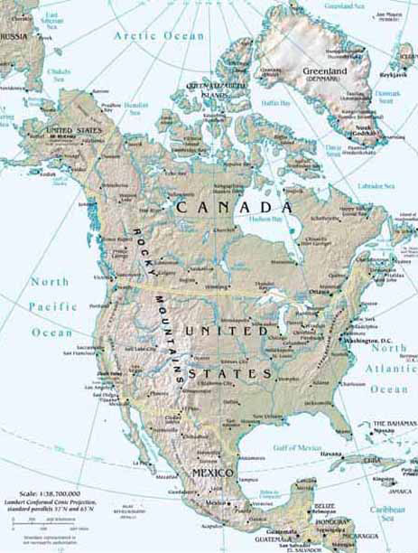
North America
On this page, we will be showing you the major weather/geographical events of Canada, Mexico, and the United States of America.

Contents
- 1 United States of America
- 1.1 Latitude and Longitude
- 1.2 Elevation Range
- 1.3 Highest Point
- 1.4 Lowest Point
- 1.5 Large Bodies of Water
- 1.6 Major Rivers
- 1.7 Major Topographic Features
- 1.8 Bordering Oceans
- 1.9 Average Monthly High/Low (Temperature in Celsius)
- 1.10 Average Monthly Rainfall (in mm)
- 1.11 Average Monthly Precipitation (in mm)
- 1.12 Climate Zone (Koppen Classification System)- Bsk and Cfa
- 1.13 Effects on the Climate
- 1.14 Geology
- 1.15 Tectonic Plates
- 2 Mexico
- 2.1 Latitude and Longitude
- 2.2 Elevation Range
- 2.3 Highest Point
- 2.4 Lowest Point
- 2.5 Largest Bodies of Water
- 2.6 Major Rivers
- 2.7 Major Topographic Features
- 2.8 Bordering Oceans
- 2.9 Average Monthly High/Low (Temperature Celsius)
- 2.10 Average Monthly Rainfall
- 2.11 Average Monthly Precipitation
- 2.12 Climate
- 2.13 Climate Zone (Koppen Classification System)
- 2.14 Effects on the Climate
- 2.15 Geology
- 2.16 Plate Tectonics
- 2.17 Boundary Types
- 2.18 Margin Types
- 3 Canada
- 3.1 Latitude and Longitude
- 3.2 Elevation Range
- 3.3 Highest Point
- 3.4 Lowest Point
- 3.5 Large Bodies of Water
- 3.6 Major Rivers
- 3.7 Major Topographic Features
- 3.8 Bordering Oceans
- 3.9 Climate Zone (Koppen Classification System)
- 3.10 Effects on the Climate
- 3.11 Geology
- 3.12 Plate Tectonics
- 3.13 Volcanoes
- 3.14 Earthquakes
- 3.15 Types of Rock and the Relationship to Tectonic Activity
- 4 Citations
United States of America
Latitude and Longitude
Atlanta, GA: 33° 74´ N, 84° 38´ W Chicago, IL: 41° 87´ N, 87° 62´ W Miami, FL: 25° 78´ N, 80° 22´ W Washington, DC: (capital city) 38° 89´ N, 77° 03´ W [4]
Elevation Range
20,320 ft. (6,194 m) to (-282 ft.) (-86 m) [5]
Highest Point
Mt. McKinley, (Alaska) 20,320 ft. (6,194 m). [5]
Lowest Point
Death Valley, (California) (-282 ft.) (-86 m) [5]
Large Bodies of Water
Great Salt Lake, Utah, and Lake Okeechobee, Florida.
Major Rivers
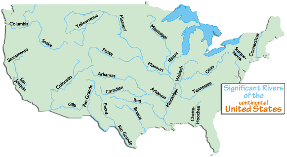 [6]
Some major rivers are: Brazos, Churchill, Colorado, Columbia, Fraser, Mackenzie, Mississippi, Missouri, Ohio, Rio Grande, St. Lawrence, and Yukon
[6]
Some major rivers are: Brazos, Churchill, Colorado, Columbia, Fraser, Mackenzie, Mississippi, Missouri, Ohio, Rio Grande, St. Lawrence, and Yukon
Major Topographic Features

Significant Appalachian ranges:
-The Cumberland Mts. in TN
-The Blue Ridge Mts. in VA
-The Alleghenies in PA
-The Catskills Mts. in NY
-The Green Mts. in VT
-The White Mts. of NH
Significant Rocky Mountain ranges include: Absaroka, Bear River, Beaverhead, Big Belt, Big Horn, Bitterroots, Canadian, Clearwater, Columbia, Front, Guadalupe, Laramie, Lamhl, Lewis, Lost River, Medicine Bow, Monashee, Owyhee, Purcell, Sacramento, Salmon River, San Andres, Sangre de Cristo, Sawatch, Shoshone, Steens, Stillwater, Swan, Tetons, Unita, Wallowa, Wasatch, Wind River, Wyoming, Zuni
Bordering Oceans
Atlantic Ocean, Pacific Ocean
Average Monthly High/Low (Temperature in Celsius)
(In Houston Intercontinental Airport, Harris County, Texas USA)
January High: 16.1 degrees Celsius January Low: 4.2 degrees Celsius [8]
Average Monthly Rainfall (in mm)
(In same place)
January: 98.1 mm. [8]
Average Monthly Precipitation (in mm)
(in same place)
January: 83.5 mm. [8]
Climate Zone (Koppen Classification System)- Bsk and Cfa

A - Tropical Climates Tropical moist climates extend north and south from the equator to about 15° to 25° latitude. In these climates all months have average temperatures greater than 64°F (18°C) and annual precipitation greater than 59".
B - Dry Climates The most obvious climatic feature of this climate is that potential evaporation and transpiration exceed precipitation. These climates extend from 20°-35° North and South of the equator and in large continental regions of the mid-latitudes often surrounded by mountains.
C - Moist Subtropical Mid-Latitude Climates This climate generally has warm and humid summers with mild winters. Its extent is from 30°50° of latitude mainly on the eastern and western borders of most continents. During the winter, the main weather feature is the mid-latitude cyclone. Convective thunderstorms dominate summer months.
D - Moist Continental Mid-latitude Climates Moist continental mid-latitude climates have warm to cool summers and cold winters. The location of these climates is poleward of the C climates. The average temperature of the warmest month is greater than 50°F (10°C), while the coldest month is less than -22°F (-30°C). Winters are severe with snowstorms, strong winds, and bitter cold from Continental Polar or Arctic air masses.
H - Highlands Unique climates based on their elevation. Highland climates occur in mountainous terrain where rapid elevation changes cause rapid climatic changes over short distances.

Bsk: Mid-latitude steppe- Mid-latitude dry.
Evaporation exceeds precipitation on average but is less than potential evaporation.
Average temperature is less than 64°F (18°C).
Cfa: Humid subtropical- Mild with no dry season, hot summer. Average temperature of warmest months are over 72°F (22°C). Average temperature of coldest month is under 64°F (18°C). Year around rainfall but highly variable.
Effects on the Climate
Latitude: Temperatures in the northern part of the US are generally colder than the southern part because temperatures are generally colder toward the poles.
Elevation: Temperatures are generally colder at higher elevations so temps. on the West Coast will generally be colder.
Topography: In the mountains, like the Rocky and Appalachian ranges, the topography causes the air to be colder and more humid on the windward side of the mountain than the leeward side of the mountain. The leeward side of the mountain tends to be warmer and drier.
Proximity to Water: The US is surrounded by the Atlantic and Pacific Ocean. The climates on the coast will be more mild than inland because the temperature range of large bodies of water is small.
Prevailing Winds: Prevailing Westerlies move air masses like Maritime and Continental Tropical west to east. The masses create spells of either humid, warm air or hot and dry air.
Vegetation: The vegetation differs from area to area in the US. For example, in the forest areas, the climate tends to be cooler than desert regions because the trees absorb more sunlight and heat causing the ground to not be as hot. The climate in forest areas also tends to be more humid because the trees and vegetation release water vapor through transpiration. [11]
High or Low Pressure Zone: In areas of lows, the climate is warmer and the air is less dense. In areas of highs, the air is colder and denser.
Ocean Currents: The Gulf Stream (a warm ocean current) warms the East Coast. The California stream (cool current) cools the West Coast.
Geology
Rock Types: Sedimentary rocks are the most widespread in the United States. These rocks are the result of deposition and following cementation of sediments. [12] Metamorphic rocks take a long time to change, so that type of rock is not as widespread, though clumps metamorphic rocks appear near the California area. These metamorphic rocks form from tectonic plates shifting and earthquakes. The heat from the rubbing of plates together causes the rock in that area to undergo regional metamorphism. Most igneous rocks are near the west coast because volcanoes and volcanic activity is more common there.
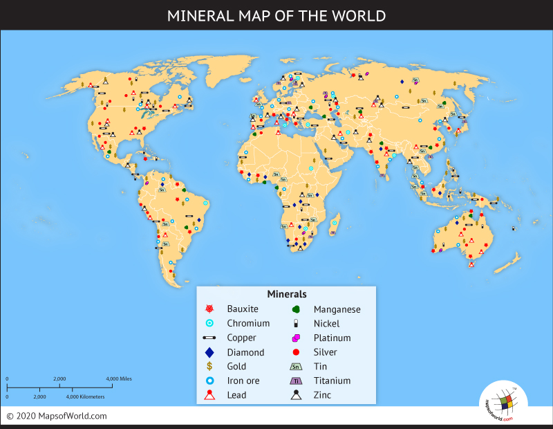
Minerals:
The major minerals in the United States are coal, iron ore, copper, silver, phosphate, molybdenum, talc, boron, lead, platinum, and gold.[13] The major minerals in the United States are coal, iron ore, copper, silver, phosphate, copper, molybdenum, talc, boron, lead, platinum, and gold. There are a lot of minerals mines on the west coast. There is a lot of lead in southwest Missouri. There is a lot of phosphate in Florida. There is a lot of talc on the east coast. [14] There is a band of coal mines from North Dakota to upper Florida. [15] Some metals, such as platinum, magnesium, cobalt, chromium, tin, and nickel are scarce in the US, and must be imported. [16]
Mining Resources:
There is a band of coal mines from North Dakota to upper Florida. [15] Most of the copper in the United States is produced in Arizona, Utah, New Mexico, Nevada, and Montana. [17] Silver in the U.S. is produced mostly in Alaska, and some in Nevada. [18] Colorado, Idaho, Nevada, and New Mexico each has one mine that produces molybdenum. [19]
There are a lot of minerals mines on the west coast. There are six lead mines in Missouri. [20] Many phosphate mines are in Florida. Talc mines are abundant on the east coast. [13]
Some metals, such as platinum, magnesium, cobalt, chromium, tin, and nickel are scarce in the US, and must be imported. [21]
Tectonic Plates
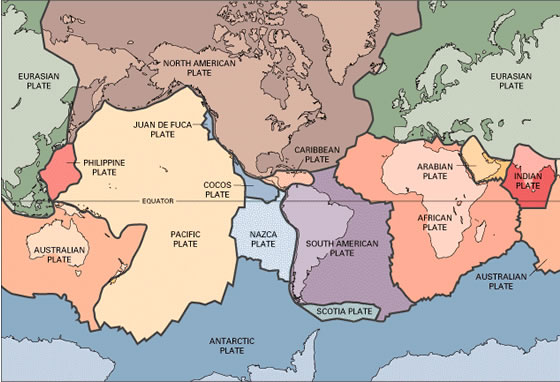
All of the United States mainland is on the North American Plate, except for Hawaii which is on the Pacific Plate. Although the whole U.S. mainland only falls on one main plate, many other plates and their boundaries border the U.S. The northwest region of the U.S. borders the subducting Juan de Fuca Plate, and the Pacific Plate subducts under Alaska, or the North American Plate. [23]
Boundary Types: The boundary between the North American Plate and the Juan de Fuca Plate is a convergent (subduction) boundary. The boundary between the North American Plate and the Pacific Plate near the middle of California is a transform boundary, and the boundary between those two plates near Alaska is a convergent (subduction) boundary. The boundary between the North American and Eurasian Plate is a divergent boundary. The boundary between the North American Plate and the Cocos Plate is a convergent (subduction) boundary. The boundary between the North American Plate and Caribbean Plate is mostly transform boundaries, and in some plates convergent (subduction) boundaries. The boundary between the Pacific Plate and the Antarctic Plate is divergent, and the boundary between the Pacific and Nazca Plate is also divergent. The boundary between the Pacific and Australian Plate is mostly convergent (subduction), and also with the Philippine Plate. [24]
Margin Types: The U.S. has active and passive margins. Most of the margins on the west coast are active, while most of the margins on the east coast are passive. The margin between the North American and the subducting Juan de Fuca Plate is active along with the margin where the transform boundary between the North American and Pacific Plate occurs. The margin between the North American and Pacific Plate near Alaska and the Aleutian Islands is very active also. The margin between the Pacific The east coast has all passive margins because the coast is no where near the leading edge of a plate boundary. [24]
Volcanoes
Volcanoes exist all over the United States, Alaska, and Hawaii, and mostly on the west coast where the active margins reside. Many volcanic eruptions occur on the volcanic island arc of Hawaii. The main type of volcanoes on the west coast are composite, which involve alternating layers of ash and andesitic magma. Many are also shield volcanoes, which form from layers of basaltic lava. The build up of ash and debris around a large volcano can cause a chain of cinder cones that also create clusters on the west coast. Volcanoes in Hawaii are mostly basaltic lava shield volcanoes, like Mauna Loa, because basaltic magma is mainly located on oceanic hot spots. Since the Pacific Plate subducts underneath Alaska, and Alaska is on an active margin, volcanoes take place on the overriding plate in Alaska frequently. The volcanoes are mostly composite due to the andesitic magma found commonly in the area. A recent volcanic eruption occurred on March 15, 2009, at the composite volcano Mount Redoubt in Alaska. [25] The most well known volcanic eruption in the 20th century was the composite volcano, Mt. St. Helens, Washington, that occurred from 1980-1986. It killed many, and destroyed 596 square kilometers of land. [26]
Earthquakes
In the same area where volcanoes originate, earthquakes occur. Most earthquake activity takes place around the active margin on the west coast of the U.S. (California area) and Alaska, but activity is also sprinkled throughout the whole mainland. Earthquakes happen in Alaska very frequently because of the subducting Pacific Plate. A recent magnitude 4.1 earthquake occurred on April 17, 2012 offshore Northern California. [27] Another recent earthquake was a 4.2, and it occurred on April 18, 2012, around Fox Islands, in the Aleutian Islands in Alaska. A major earthquake in the history of the U.S. took place in Prince William Sound, Alaska, and was a 9.2- the second largest earthquake in the world and the largest earthquake in Alaska to date. It killed 128 people and caused heavy damage along with the tsunami that occurred afterwards.[28]
Type of Rock and the Relationship to Tectonic Activity
The type of rock in the U.S. related to tectonic activity is andesitic rock on the west coast where subduction boundaries are, and basaltic rock in Hawaii and the Aleutian Islands area where oceanic hot spots exist.[29]
Mexico
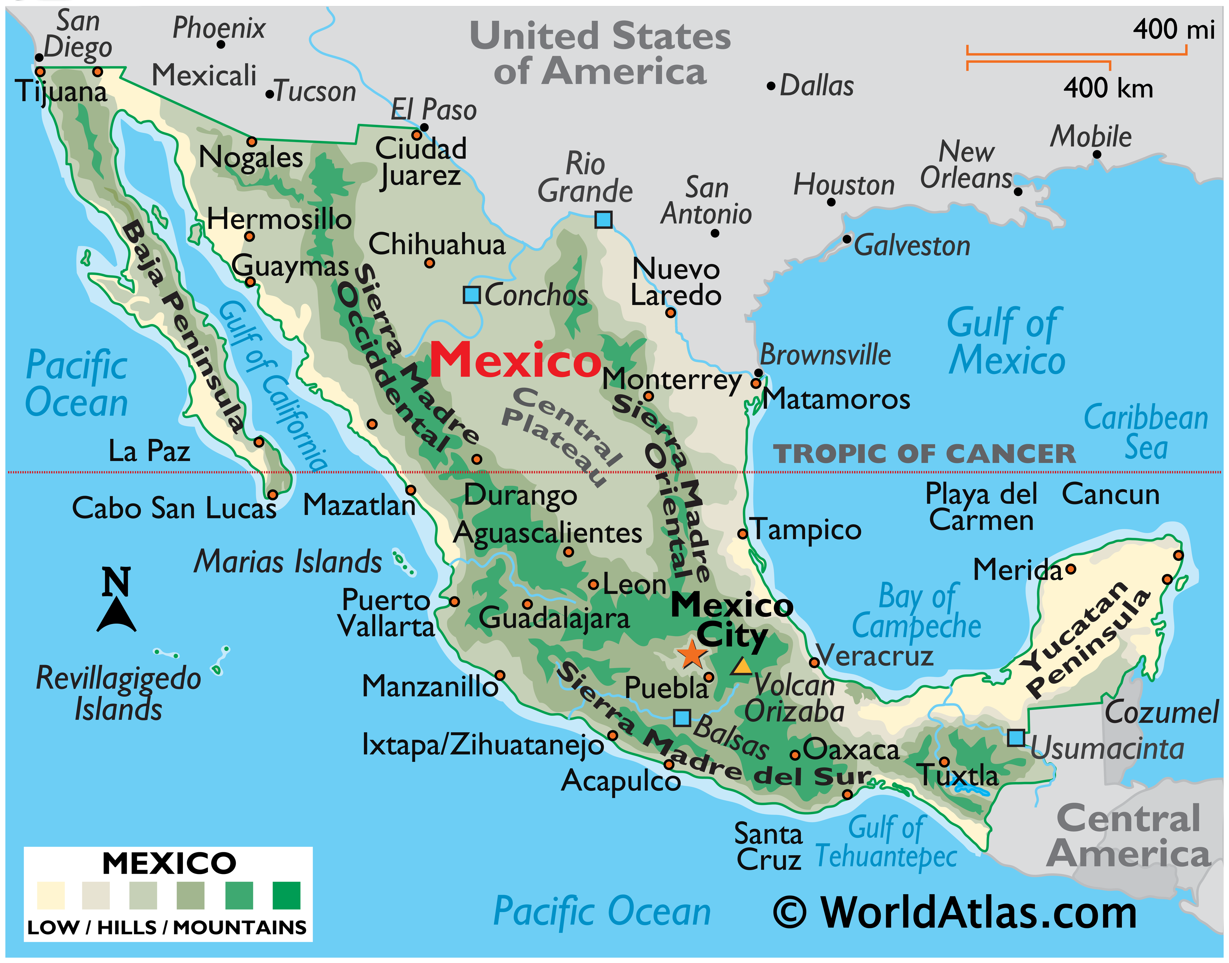
Latitude and Longitude
30 N 81 W [2]
Elevation Range
1,500m [3]
Highest Point
Volcan Pico de Orizaba, 5,700 m [4]
Lowest Point
Laguna Salada, -10 m [5]
Largest Bodies of Water
There are no lakes in Mexico but there is the Gulf of Mexico and the Gulf of California.[6]
Major Rivers
Rio Grande, Puebla Conchos, Usumacinta [7]
Major Topographic Features
Sierra Madre Occidental, Gulf Coastal Plain, Central Mexican Plateau, Baja Peninsula [8]
Bordering Oceans
Gulf of Mexico, Pacific Ocean, Caribbean Sea [9]
Average Monthly High/Low (Temperature Celsius)
Low= 13.3[10] High=16.1
Average Monthly Rainfall
634.3 mm [11]
Average Monthly Precipitation
Climate
It is hot and dry in Mexico. Rain occurs on occasions but rarely. [14]
Climate Zone (Koppen Classification System)
BWh: Low-latitude desert. Evaporation exceeds precipitation on average but is less than half potential evaporation. Average temperature is more than 64°F (18°C). Frost is absent or infrequent.[15]
Effects on the Climate
Latitude: Mexico is far away from the poles and close to the equator and ITZC, so the latitude makes it hot and dry.
Elevation: Most of Mexico is at sea level (besides the mountain ranges) so it is very hot.
Topography: There are many mountain ranges in Mexico, so it is colder on the mountains, but the mountains contain less moisture.
Proximity to Water: Mexico is in between two big bodies of water. The temperature range is small near water masses, so it's either hot or not.
Prevailing Winds: Maritime Tropical winds form over the ocean and travel down to Mexico.
Vegetation: Mexico has a lot of deserts which reflect heat and it also heats up and cools down faster.
High/Low Pressure Zone: Mexico has a high pressure zone which makes storms travel away.
Ocean Currents: Warm ocean currents warm nearby coasts.
Geology
Mining Resources: [17]Mexico has 3 major natural metallic minerals that are mined in Mexico. The first one is copper. Copper is located from about 500 kilometers to 10 kilometers from the ocean. It is mostly in the north-western part of Mexico. The second metallic is Iron. Iron is located from about 200 kilometers to 50 kilometers from the ocean. It is mostly in the central part of Mexico both North and South. The last metallic is silver. Silver is located in the eastern part of North and South Mexico.
Minerals: [18]Mexico’s main minerals are Graphite and Gypsum. Gypsum is located on the very eastern side of the peninsula next to the Gulf of California. Graphite is on the western side of the Gulf of California.
Rock Types:[19][[20]] Mexico has a large amount of intrusive rock which is magma that cools under the crust. It is mostly on the western and eastern coasts. Mexico also has a large amount of extrusive igneous rock which is cooled lava from a volcano. Extrusive igneous rock is mostly on the western side of Mexico. Mexico also has plenty of sedimentary rocks all over, but mostly located on the eastern side of Mexico, because there are a lot of rivers and there is the Gulf of Mexico. Mexico has very little metamorphic rocks located at the very end of Mexico, near Central America, they are there because of mountain ranges and mountain building.
Plate Tectonics

The plates that Mexico is on are the Caribbean Plate (Mexico is a passive margin), the North American Plate (Mexico is a passive margin), the Cocos Plate (Mexico is a passive margin), and a teeny bit is on the Pacific Plate and South American Plate.
Boundary Types
 [22]
The boundary types are convergent at Cocos and Caribbean plates, transform at Pacific boundary and North American Boundary, divergent at Caribbean and North American, and convergent at South American and Caribbean plates.
[22]
The boundary types are convergent at Cocos and Caribbean plates, transform at Pacific boundary and North American Boundary, divergent at Caribbean and North American, and convergent at South American and Caribbean plates.
Margin Types
Mexico is a passive margin on the Pacific plate/North American plate boundary.
Volcanoes
There are volcanoes all over Mexico, especially on the North American and Cocos, and on the Caribbean and North American convergent boundaries.
There are some volcanoes in the Baja peninsula. The Durango Volcanic Field is in the NW corner of the Meseta Central near the eastern edge of the Sierra Madre Occidental of north-central Mexico. There are also many volcanoes along the divergent Caribbean and North American boundaries.
In Mexico the west coast volcanoes are composite volcanoes with andesitic lava, and in the east coast/central most volcanoes are cinder cone volcanoes with andesitic lava, and the Baja Peninsula is mostly Cinder cones with basaltic and andesitic lava. The recent eruptions were at Socorro in 1993, Popocatepetl in 2006, and Colima in 2005. The The seemingly dormant El Chichón in Chiapas, Mexico, erupted unexpectedly and spectacularly, wiping out nine villages and killing an estimated 1,900 people. The volcano had been slumbering for nearly 600 years, but in 1982, it erupted three times in less than a week in 1982, on March 29, April 3 and April 4. It is the largest volcanic disaster in modern Mexican history.
Earthquakes
There are many Earthquakes in Mexico, one of the latest one April 14, 2012, about a week ago. Most Earthquakes are in the Baja peninsula, Pacific coast, and on the Caribbean/North American plate boundary. Recent Earthquakes in the Baja regions are a 7.2 on April 4, 2010, and a 5.3 on June 15, 2004. On the Pacific side, some recent ones are a 5.2 on January 1, 2004, a 7.8 on January 21, 2003, a 7.6 on October 9, 1995, and a 7.2 on September 14, 1995. In central Mexico there was a 6.5 on June 15, 1999.
The most historic earthquakes were as followed: 6.9 in Guerrero Gap (Pacific Coast) on April 25, 1989 8.0 in Guerrero-Michoacan (Mexico City) on September 19, 1985 6.5 in Huajuapan de Leon on October 24, 1980 6.2 in Mexicali, Baja on June 9, 1980 7.7 in Guerrero on March 14, 1979 7.9 in Oaxaca on November 29, 1978 7.0 in Veracruz on August 28, 1973
Types of Rock and the Relationship to Tectonic Activity
The type of rock in the region related to tectonic activity is continental rhyolitic.
Canada
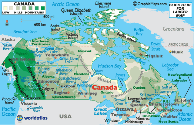
Latitude and Longitude
56 7 N / 106 20 W [24]
Elevation Range
5,559 m [25]
Highest Point
Mt. Logan (Yukon), 5,559 m [26]
Lowest Point
Atlantic Ocean, 0 m [27]
Large Bodies of Water
Hudson Bay, Baffin Bay, Labrador Sea, Beaufort Sea, Great Lakes, Great Bear Lake, Great Slave Lake, James Bay, Lake Winnipeg, and Welland Canal [28]
Major Rivers
Ottawa River, Columbia River, St. Lawrence River, Albany River, Nelson River, Saskatchewan River, Athabasca River, Peace River, Liard River, MacKenzie River, Yukon River, and Fraser RIver [29]
Major Topographic Features
Appalachian Mts., Canadian Arctic Archipelago, Canadian Shield, Canada Cordillera, Great Plains, and Rocky Mountains [30] [31]
Bordering Oceans
Atlantic Ocean, Pacific Ocean, Arctic Ocean [32]
Climate Zone (Koppen Classification System)
ET - Northern Canada - Tundra - Polar Tundra - no true summer, Dsc - Mid-Northern Canada - Subarctic - cold, dry summer, Dfa - Southeastern Canada - Humid Continental - humid with hot summer, Csb - Western Canada - Mediterranean - mild with cool, hot summer, BSk - Mid-Southern Canada - Mid-lattitude steppe - Mid-lattitude dry [33]
Effects on the Climate
Latitude: Canada is close to the poles and far from the equator causing the temperature to be cold.
Elevation: Canada has high elevation cooling the temperatures.
Topography: Canada contains lots of mountains cooling the temperature and makes more precipitation.
Proximity to Water: The water near Canada is cool, so it cools the land.
Prevailing Winds: Prevailing Westerlies push cool, moist Maritime Polar air masses from west to East across Canada. Also, these Prevailing Westerlies push cold, dry Continental Polar air masses across southern Canada.
Vegetation: Many forests and Tundras in Canada help cool the surface contributing to cooler temperatures.
High/Low Pressure Zone: In the Polar Area of Canada, cold, dense air sinks, causing high pressure at the surface. At 60 degrees latitude in Canada warm air rises causing low pressure at the surface. Also in this area, Polar Fronts occur and it is cold.
Ocean Currents: Cool ocean currents cool nearby coasts.
Geology
Rock Types: The reason for the formation of the Igneous Rocks on the west coast of Canada is because of the Volcanoes. As Igneous Rocks form from the melting of other rocks into lava followed by the cooling, the abundance of this rock type in this area makes lots of sense. A safe conclusion for the Igneous Rocks located in Canada is that for the most part they are located on or around the mountain ranges.
Also, throughout the formation of Sedimentary Rocks it is known that Uplift, Weathering, Erosion, Deposition, Burial, Compaction, and Cementation take place. By this knowledge we can come to find that perhaps a reason for the widespread amounts of Sedimentary Rocks throughout the country is that Sedimentary Rocks normally for around bodies of water or areas of harsh conditions. These two facts are very true for most of Canada because it basically snows throughout the whole country at one point which can account for water if the formation is not already by a lake or river. Next, along with this snow comes other forces of nature such as wind which can also contribute to the formation of Sedimentary Rocks in this Northern Country. It is almost safe to say that Sedimentary Rocks are able to form throughout most parts of the country with ease and are probably the most abundant rock type as well.
Lastly is the Metamorphic Rock. This rock type which is formed by heat and or pressure is probably the second most abundant rock type in Canada, only behind Sedimentary by a little bit. First of all, although heat is not always constant and available in the Northern parts of Canada where lots of the Metamorphic Rock is located, there is still plenty of pressure. Through wind and the force of snow and ice pushing down on rocks and the Earth it is highly possible for there to plenty Metamorphic Rocks in that region. Overall, this rock is rarely formed directly from Igneous Rock in Canada as Sedimentary Rock mostly holds the middle part of the country, separating the two. As a conclusion, Metamorphic Rock, is quite abundant in the area as there is plenty of pressure to help form this rock type.
Minerals and Mineral Resources: There are several main Mineral Resources in Canada such as: Lead, Copper, Gold, Iron, and Diamond. The Lead, which for the most part is found in Southern Canada which is connected with all three rock types. Next, Copper, which is also found in Southern Canada is also connected to Igneous, Sedimentary, and Metamorphic Rocks. Next, Gold, which is found in the central part of Canada is mainly involved with Metamorphic Rocks. Diamond, which is only found in Northern Canada is also only involved with Metamorphic Rocks. Lastly, Iron, which is found on the eastern part of the country is only involved with Metamorphic Rocks. As a conclusion, it seems that Metamorphic Rocks very often are part of common mineral resources.
Plate Tectonics

Canada is located on the North American Plate bordering the Pacific plate which subducts under the North American plate at most of the border. Canada also borders the Juan de Fuca Plate (Southwest Coast)which also subducts under the North American Plate. Canada has an active margin with the Juan de Fuca and Pacific Plates as subduction and formations of mountains, volcanoes, and other tectonic activity are taking place. (Boundary Types) (Margin Types)
Volcanoes

Volcanoes are present in Canada. Most of the volcanoes in Canada are located along the convergent boundaries on the west coast of Canada between the North American and Juan de Fuca or Pacific Plates. The major volcanoes in that area are Volcano Mt., Volcanic Creek, Ruby Mt., South Tuya, Cracker Creek, Ash Mt.,Mathew's Tuya, Tuya Butte, Edziza, Hoodoo, Iskut, Lava Fork, Tseax, Nazko, Wells Gray, Meager, Garibaldi, and Watts Point. The types of volcanoes located in this area are Strato (Composite), Shield, Cinder Cone, and Subglacial. The majority of the magma of the volcanoes is Basaltic except for the Stratovolcanoes (Composite), which is composed of Andesitic magma.
There have been only a few eruptions in Canada. Some of these include the Tseax eruption in 1750-1775 which killed 2,000 from the spewing of lava. Also there was the Mount Meager eruption 2,400 years ago with plumes of ash, a pyroclastic flow, and a short lava flow. Lastly, 8,000 years ago there was the Garibaldi eruption where it created the Ring Creek with its lava flow.
Earthquakes

There are many earthquakes in present in Canada mostly present along the West Coast, Northern Islands and Areas, and the Southeast Coast. The earthquakes along the West Coast are primarily caused because of the plate boundaries, while the earthquakes on the Southeast Coast and Arctic region are somewhat a mystery in terms of why they are present. The largest earthquake in this century in Canada occurred in 1949 (magnitude 8.1) in British Columbia. In 1929, a 7.2 magnitude earthquake occurred creating a large tsunami that killed a few dozen. In November 1988, a magnitude 6 earthquake in the Quebec area caused thousands of dollars in damage.
Recent Earthquakes in/near Canada (Significant)
2012-04-22: M=4.7 - Offshore Vancouver Island 2012-04-13: M=3.1 - 15 km ENE of La Malbaie, QC - felt 2012-04-11: M=4.4 - 207 km SSW of Shelburne, NS - felt 2012-04-07: M=3.1 - 15 km E of Wakefield, QC - felt 2012-03-30: M=3.4 - 46 km WSW of Bathurst, NB - felt [42]
Types of Rock and the Relationship to Tectonic Activity
The types of rock found on the west coast of Canada is split between Basaltic - at the Shield, Cinder Cone, and Subglacial volcanoes, and Andesitic - at the Subduction boundary.
Citations
http://www.worldatlas.com/webimage/countrys/namerica/us.htm http://www.worldatlas.com/webimage/countrys/namerica/mexico/mxlatlog.htm http://www.worldatlas.com/webimage/countrys/namerica/mx.htm http://www.worldatlas.com/webimage/countrys/namerica/mexico/mxland.htm http://www.worldatlas.com/webimage/countrys/namerica/mexico/mxlandst.htm
http://www.worldatlas.com/aatlas/latitude_and_longitude_finder.htm http://www.worldatlas.com/webimage/countrys/namerica/calandst.htm http://www.worldatlas.com/webimage/countrys/namerica/camaps.htm http://www.worldatlas.com/webimage/countrys/namerica/lgcolor/cacolor.htm http://www.worldatlas.com/webimage/countrys/namerica/caland1.htm http://www.worldatlas.com/webimage/countrys/namerica/caland2.htm http://www.worldatlas.com/webimage/countrys/namerica/calandst.htm http://www.srh.noaa.gov/jetstream/global/climate_max.htm http://www.classzone.com/books/earth_science/terc/content/investigations/es2101/es2101page02.cfm?chapter_no=investigation http://www.craigmarlatt.com/canada/geography&maps/maps_vegetation.htm http://jersey.uoregon.edu/~mstrick/AskGeoMan/geoQuerry26.html
- ↑ United States. Picture. World Atlas. http://www.worldatlas.com/webimage/countrys/nalnd.htm
- ↑ North America. Picture. Volcano World. http://volcano.oregonstate.edu/
- ↑ 3.0 3.1 World. Picture. Map. http://www.mapsofworld.com/world-mineral-map.htm
- ↑ United States. Website. World Atlas. http://www.worldatlas.com/webimage/countrys/namerica/usstates/uslatlog.htm
- ↑ 5.0 5.1 5.2 United States. Website. World Atlas. http://www.worldatlas.com/webimage/countrys/namerica/usstates/uslandst.htm
- ↑ United States Rivers. Picture. World Atlas. http://www.worldatlas.com/webimage/countrys/namerica/usstates/artwork/rivers/uslayout.htm
- ↑ United States. Picture. http://www.worldatlas.com/webimage/countrys/usanewe.htm.
- ↑ 8.0 8.1 8.2 Houston. United States. Website. http://www.worldclimate.com/cgi-bin/grid.pl?gr=N29W095
- ↑ United States. Picture. National Weather Service. http://www.srh.noaa.gov/
- ↑ United States. Picture. National Weather Service. http://www.srh.noaa.gov/jetstream/global/climate_max.htm
- ↑ United States. Earth Science Textbook. By Nancy E. Spaulding and Samuel N. Namowitz.
- ↑ United States. Website. National Atlas. http://nationalatlas.gov/articles/geology/types/sedimentary.html
- ↑ 13.0 13.1 United States. National Mining Association. Information. http://www.nma.org/pdf/fact_sheets/mas.pdf
- ↑ United States. Info. PDF. http://www.nma.org/pdf/fact_sheets/mas.pdf
- ↑ 15.0 15.1 United States. Website. How Stuff Works. http://maps.howstuffworks.com/world-energy-minerals-map.htm
- ↑ Use of Minerals. Textbook.
- ↑ United States. U.S. Geological Survey. Info. PDF. http://minerals.usgs.gov/minerals/pubs/commodity/copper/mcs-2012-coppe.pdf
- ↑ United States. U.S. Geological Survey. Info. PDF. http://minerals.usgs.gov/minerals/pubs/commodity/silver/mcs-2012-silve.pdf
- ↑ United States. U.S. Geological Survey. Info. PDF. http://minerals.usgs.gov/minerals/pubs/commodity/molybdenum/mcs-2012-molyb.pdf
- ↑ United States. U.S. Geological Survey. Info. PDF. http://minerals.usgs.gov/minerals/pubs/commodity/lead/mcs-2012-lead.pdf
- ↑ United States. Earth Science Textbook. By Nancy E. Spaulding and Samuel N. Namowitz.
- ↑ World. Map. San Joaquin Valley Geology. http://www.sjvgeology.org/geology/tectonics.html
- ↑ World. Map. California Institute of Technology Tectonics Observatory. http://www.tectonics.caltech.edu/images/maps/plates.pdf
- ↑ 24.0 24.1 World. Earth Science Textbook. Page 712-713. By Nancy E. Spaulding and Samuel N. Namowitz.
- ↑ Mt. Redoubt. Alaska. Info. Alaska Volcano Observatory. http://www.avo.alaska.edu/volcanoes/volcinfo.php?volcname=Redoubt
- ↑ World. Info. Cascades Volcano Observatory. http://vulcan.wr.usgs.gov/LivingWith/VolcanicFacts/volcanic_impact.html
- ↑ California. Info. USGS. Earthquake Hazards Program. http://earthquake.usgs.gov/earthquakes/recenteqsus/Quakes/nc71766345.html
- ↑ Alaska. Info. USGS. Earthquake Hazards Program. http://earthquake.usgs.gov/earthquakes/states/events/1964_03_28.php
- ↑ Earth Science Textbook. Chapter 9.2. By Nancy E. Spaulding and Samuel N. Namowitz.
Created by Maddie Shen, Daniel Perrier, Christina Ru, and Elysa Tulek.