Difference between revisions of "Earth Science 7 North America 5"
(→'''United States of America''') |
(→'''United States of America''') |
||
| Line 4: | Line 4: | ||
='''United States of America'''= | ='''United States of America'''= | ||
| − | http://www.worldatlas.com/webimage/countrys/namerica/usstates/artwork/rivers/uslayout. | + | http://www.worldatlas.com/webimage/countrys/namerica/usstates/artwork/rivers/uslayout.gif |
==Latitude and Longitude== | ==Latitude and Longitude== | ||
Revision as of 19:55, 3 November 2011
North America
On this page, we will be showing you the major weather/geographical events of Canada, Mexico, and the United States of America.
United States of America

Latitude and Longitude
Elevation Range
Highest Point
Mt. McKinley, (Alaska) 20,320 ft. (6,194 m). [1]
Lowest Point
Death Valley, (California) (-282 ft.) (-86 m)
Large Bodies of Water
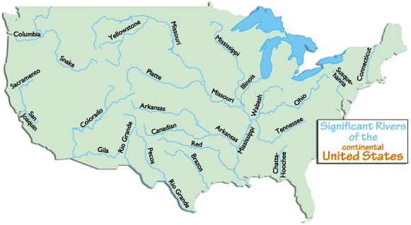
Major Rivers
Some major rivers are: Brazos, Churchill, Colorado, Columbia, Fraser, Mackenzie, Mississippi, Missouri, Ohio, Rio Grande, St. Lawrence, and Yukon
Major Mountain Ranges
Significant Appalachian ranges: -The Cumberland Mts. in TN -The Blue Ridge Mts. in VA -The Alleghenies in PA -The Catskills Mts. in NY -The Green Mts. in VT -The White Mts. of NH
Significant Rocky Mountain ranges include: Absaroka, Bear River, Beaverhead, Big Belt, Big Horn, Bitterroots, Canadian, Clearwater, Columbia, Front, Guadalupe, Laramie, Lamhl, Lewis, Lost River, Medicine Bow, Monashee, Owyhee, Purcell, Sacramento, Salmon River, San Andres, Sangre de Cristo, Sawatch, Shoshone, Steens, Stillwater, Swan, Tetons, Unita, Wallowa, Wasatch, Wind River, Wyoming, Zuni
Bordering Oceans
Atlantic Ocean, Pacific Ocean
Mexico
Latitude and Longitude
30 N 81 W [1]
Elevation Range
1,500m [2]
Highest Point
Volcan Pico de Orizaba, 5,700 m [3]
Lowest Point
Laguna Salada, -10 m [4]
Major Rivers
Rio Grande, Puebla Conchos, Usumacinta [5]
Major Topographic Features
Sierra Madre Occidental, Gulf Coastal Plain, Central Mexican Plateau, Baja Peninsula [6]
Bordering Oceans
Gulf of Mexico, Pacific Ocean, Caribbean Sea [7]
Canada
Latitude and Longitude
Elevation Range
Highest Point
Lowest Point
Elevation Range
Large Bodies of Water
Major River
Major Rocky Mountain Ranges
Bordering Oceans
Citations
http://www.worldatlas.com/webimage/countrys/namerica/us.htm http://www.worldatlas.com/webimage/countrys/namerica/mexico/mxlatlog.htm http://www.worldatlas.com/webimage/countrys/namerica/mx.htm http://www.worldatlas.com/webimage/countrys/namerica/mexico/mxland.htm http://www.worldatlas.com/webimage/countrys/namerica/mexico/mxlandst.htm
- ↑ United States. Website. World Atlas. WorldAtlas.com, http://www.worldatlas.com/webimage/countrys/namerica/usstates/uslandst.htm
Created by Maddie Shen, Daniel Perrier, Christina Ru, and Elysa Tulek.