Earth Science 7 North America 5
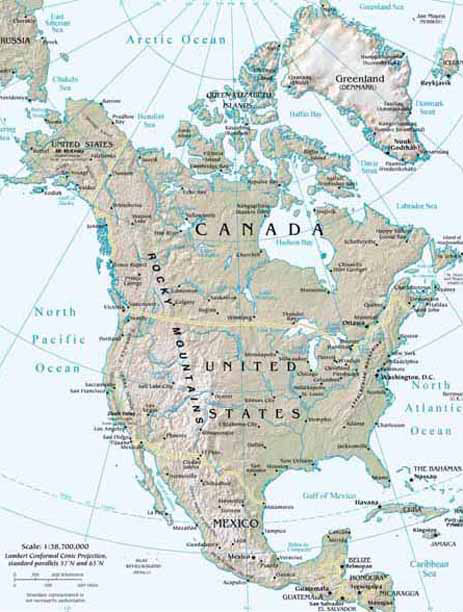
North America
On this page, we will be showing you the major weather/geographical events of Canada, Mexico, and the United States of America.
Contents
- 1 United States of America
- 1.1 Latitude and Longitude
- 1.2 Elevation Range
- 1.3 Highest Point
- 1.4 Lowest Point
- 1.5 Large Bodies of Water
- 1.6 Major Rivers
- 1.7 Major Topographic Features
- 1.8 Bordering Oceans
- 1.9 Average Monthly High/Low
- 1.10 Average Monthly Rainfall
- 1.11 Average Monthly Precipitation
- 1.12 Climate Zone (Koppen Classification System
- 2 Mexico
- 2.1 Latitude and Longitude
- 2.2 Elevation Range
- 2.3 Highest Point
- 2.4 Lowest Point
- 2.5 Largest Bodies of Water
- 2.6 Major Rivers
- 2.7 Major Topographic Features
- 2.8 Bordering Oceans
- 2.9 Average Monthly High/Low
- 2.10 Average Monthly Rainfall
- 2.11 Average Monthly Precipitation
- 2.12 Climate Zone (Koppen Classification System)
- 3 Canada
- 3.1 Latitude and Longitude
- 3.2 Elevation Range
- 3.3 Highest Point
- 3.4 Lowest Point
- 3.5 Large Bodies of Water
- 3.6 Major Rivers
- 3.7 Major Topographic Features
- 3.8 Bordering Oceans
- 3.9 Average Monthly High/Low
- 3.10 Average Monthly Rainfall
- 3.11 Average Monthly Precipitation
- 3.12 Climate Zone (Koppen Classification System)
- 4 Citations
United States of America
Latitude and Longitude
Atlanta, GA: 33° 74´ N, 84° 38´ W Chicago, IL: 41° 87´ N, 87° 62´ W Miami, FL: 25° 78´ N, 80° 22´ W Washington, DC: (capital city) 38° 89´ N, 77° 03´ W [2]
Elevation Range
20,320 ft. (6,194 m) to (-282 ft.) (-86 m) [3]
Highest Point
Mt. McKinley, (Alaska) 20,320 ft. (6,194 m). [3]
Lowest Point
Death Valley, (California) (-282 ft.) (-86 m) [3]
Large Bodies of Water
Great Salt Lake, Utah, and Lake Okeechobee, Florida.
Major Rivers
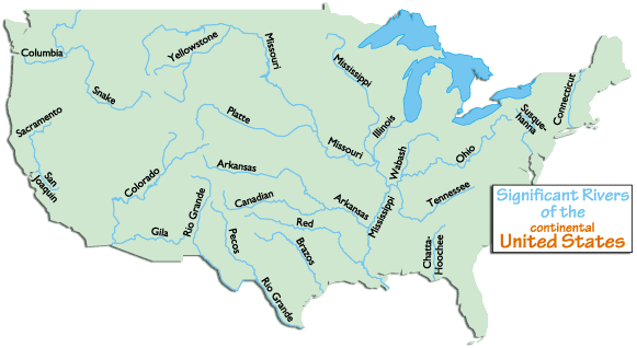 [4]
Some major rivers are: Brazos, Churchill, Colorado, Columbia, Fraser, Mackenzie, Mississippi, Missouri, Ohio, Rio Grande, St. Lawrence, and Yukon
[4]
Some major rivers are: Brazos, Churchill, Colorado, Columbia, Fraser, Mackenzie, Mississippi, Missouri, Ohio, Rio Grande, St. Lawrence, and Yukon
Major Topographic Features

Significant Appalachian ranges: -The Cumberland Mts. in TN -The Blue Ridge Mts. in VA -The Alleghenies in PA -The Catskills Mts. in NY -The Green Mts. in VT -The White Mts. of NH
Significant Rocky Mountain ranges include: Absaroka, Bear River, Beaverhead, Big Belt, Big Horn, Bitterroots, Canadian, Clearwater, Columbia, Front, Guadalupe, Laramie, Lamhl, Lewis, Lost River, Medicine Bow, Monashee, Owyhee, Purcell, Sacramento, Salmon River, San Andres, Sangre de Cristo, Sawatch, Shoshone, Steens, Stillwater, Swan, Tetons, Unita, Wallowa, Wasatch, Wind River, Wyoming, Zuni
Bordering Oceans
Atlantic Ocean, Pacific Ocean
Average Monthly High/Low
Average Monthly Rainfall
Average Monthly Precipitation
Climate Zone (Koppen Classification System
Bsk:
Cfa:
Mexico
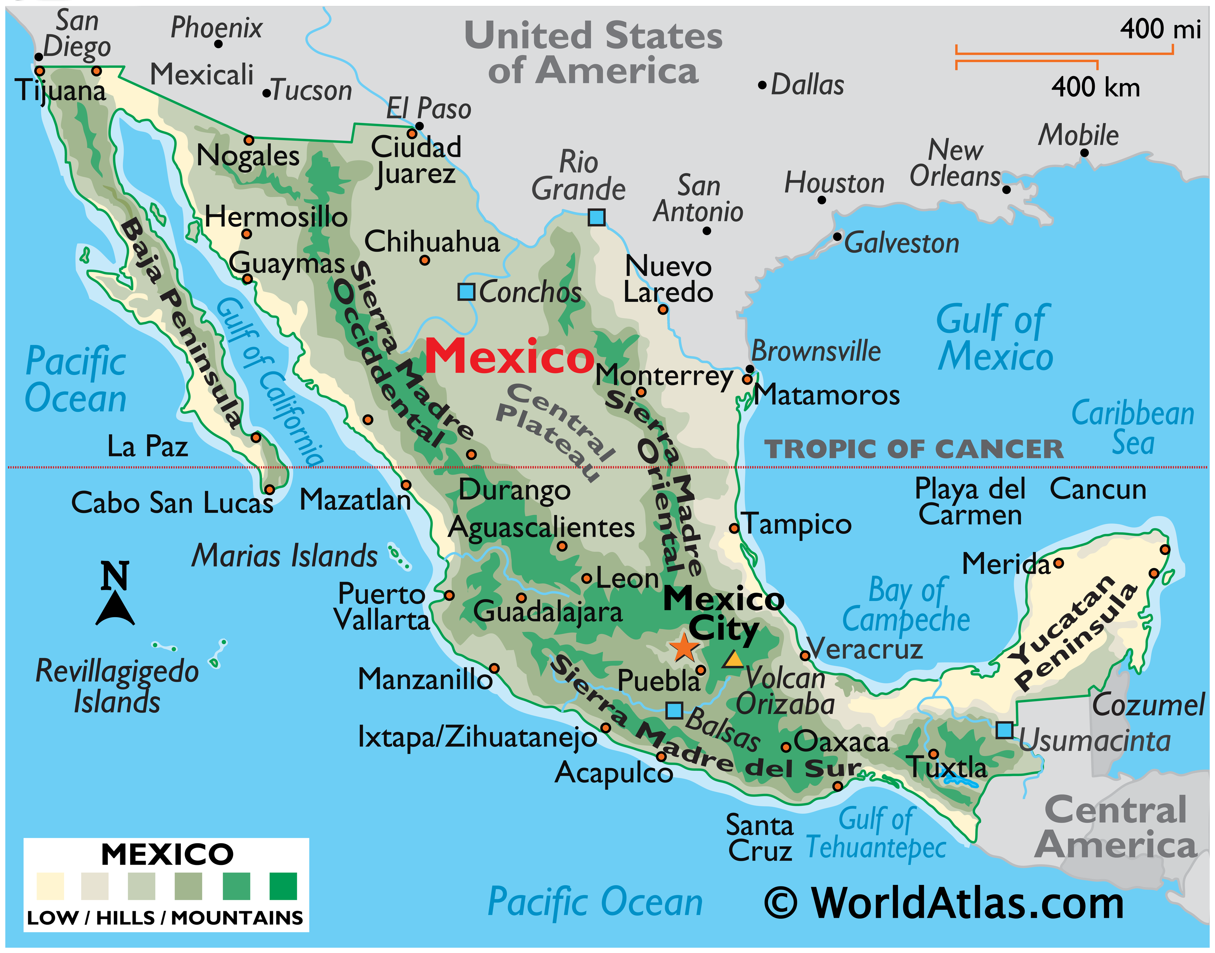
Latitude and Longitude
30 N 81 W [4]
Elevation Range
1,500m [5]
Highest Point
Volcan Pico de Orizaba, 5,700 m [6]
Lowest Point
Laguna Salada, -10 m [7]
Largest Bodies of Water
Major Rivers
Rio Grande, Puebla Conchos, Usumacinta [8]
Major Topographic Features
Sierra Madre Occidental, Gulf Coastal Plain, Central Mexican Plateau, Baja Peninsula [9]
Bordering Oceans
Gulf of Mexico, Pacific Ocean, Caribbean Sea [10]
Average Monthly High/Low
Average Monthly Rainfall
Average Monthly Precipitation
Climate Zone (Koppen Classification System)
Canada
![[2]](http://www.srh.noaa.gov/jetstream/global/images/koppenzones.jpg)
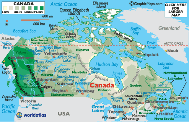
Latitude and Longitude
56 7 N / 106 20 W [12]
Elevation Range
5,559 m [13]
Highest Point
Mt. Logan (Yukon), 5,559 m [14]
Lowest Point
Atlantic Ocean, 0 m [15]
Large Bodies of Water
Hudson Bay, Baffin Bay, Labrador Sea, Beaufort Sea, Great Lakes, Great Bear Lake, Great Slave Lake, James Bay, Lake Winnipeg, and Welland Canal [16]
Major Rivers
Ottawa River, Columbia River, St. Lawrence River, Albany River, Nelson River, Saskatchewan River, Athabasca River, Peace River, Liard River, MacKenzie River, Yukon River, and Fraser RIver [17]
Major Topographic Features
Appalachian Mts., Canadian Arctic Archipelago, Canadian Shield, Canada Cordillera, Great Plains, and Rocky Mountains [18] [19]
Bordering Oceans
Atlantic Ocean, Pacific Ocean, Arctic Ocean [20]
Average Monthly High/Low
Average Monthly Rainfall
Average Monthly Precipitation
Climate Zone (Koppen Classification System)
Citations
http://www.worldatlas.com/webimage/countrys/namerica/us.htm http://www.worldatlas.com/webimage/countrys/namerica/mexico/mxlatlog.htm http://www.worldatlas.com/webimage/countrys/namerica/mx.htm http://www.worldatlas.com/webimage/countrys/namerica/mexico/mxland.htm http://www.worldatlas.com/webimage/countrys/namerica/mexico/mxlandst.htm
[21] [22] [23] [24] [25] [26] [27]
- ↑ United States. Picture. World Atlas. http://www.worldatlas.com/webimage/countrys/nalnd.htm
- ↑ United States. Website. World Atlas. http://www.worldatlas.com/webimage/countrys/namerica/usstates/uslatlog.htm
- ↑ 3.0 3.1 3.2 United States. Website. World Atlas. http://www.worldatlas.com/webimage/countrys/namerica/usstates/uslandst.htm
- ↑ United States Rivers. Picture. World Atlas. http://www.worldatlas.com/webimage/countrys/namerica/usstates/artwork/rivers/uslayout.htm
- ↑ United States. Picture. National Weather Service.

Created by Maddie Shen, Daniel Perrier, Christina Ru, and Elysa Tulek.