Asia earth science 5
Asia
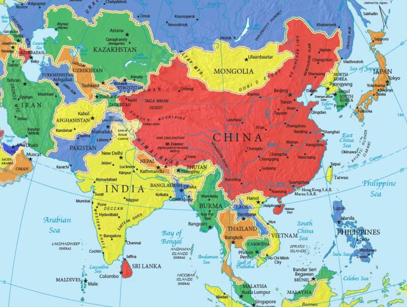 image 1
Countries of Asia
Afghanistan/ Armenia/ Azerbaijan /Bahrain/ Bangladesh/ Bhutan/ Brunei/ Cambodia/ China/ Georgia/ India/ Indonesia/ Iran/ Iraq/ Israel/ Japan/ Jordan/ Kazakhstan/ Kuwait/ Kyrgyzstan/ Laos/ Lebanon/ Malaysia/ Maldives/ Mongolia/ Myanmar/ Nepal/ "North Korea"/ Oman/ Pakistan/ Philippines/ Qatar/ Russia/ "Saudi Arabia"/ Singapore/ "South Korea"/ "Sri Lanka"/ Syria/ Tajikistan/ Thailand/ Timor-Leste/ Turkey Turkmenistan/ "United Arab Emirates"/ Uzbekistan/ Vietnam/ Yemen/
China
 image 2
Longitude and Latitude Ranges
Latitude Range: 49 degrees N-- 19 degrees N Longitude Range: 74 degrees E-- 119 degrees E [2]
Location
Eastern Asia, bordering the East China Sea, Korea Bay, Yellow Sea, and South China Sea, between North Korea and Vietnam[3]
Border countries: Afghanistan 76 km, Bhutan 470 km, Burma 2,185 km, India 3,380 km, Kazakhstan 1,533 km, North Korea 1,416 km, Kyrgyzstan 858 km, Laos 423 km, Mongolia 4,677 km, Nepal 1,236 km, Pakistan 523 km, Russia (northeast) 3,605 km, Russia (northwest) 40 km, Tajikistan 414 km, Vietnam 1,281 km[4]
Regional borders: Hong Kong 30 km, Macau 0.34 km Coastline: 14,500 km[5]
Area
Total Land Area: 9,596,961 sq km
Water: 27,060 sq km[6]
Population
Population: 1,336,718,015 (July 2011 est.)[7]
Large Bodies of Water
Yangtze River-- 3722 miles long Tonle Sap Lake-- 3860 sq. mi
Bordering Oceans
Pacific Ocean
Major Topographic Features
Qinghai-Tibet Plateau --4000 meters above sea level
Mt. Everest-- 8448 meters above sea level
Mongolia Plateau
Loess Plateau
Yunnan-Guizhou Plateau
Tarim Basin
Junggar Basin
Sichuan Basin
Northeast Plain
North China Plain
Yangtze Plain
Himalaya Mountain Range [8]
Elevation Range
8448 meters above sea level--- 154 meters below sea level [9]
Average Monthly Temperature (Fahrenheit) & Rainfall
      Highs:    Lows:   Rainfall(inches):
Jan. :34         15       0.1
Feb. :39         19       0.2
Mar. :52         30       0.4
Apr. :67         45       1.0
May. :79         55       1.1
Jun. :86         64       2.8
Jul. :87         70       6.9
Aug. :85         68       7.2
Sep. :78         57       1.9
Oct. :66         45       1.7
Nov. :50         31       0.2
Dec. :37         19       0.1
Climate Zone
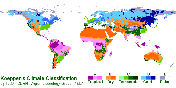 image 3
Climate: Köppen Climate Classification System
In A - Moist Tropical Climates are known for their high temperatures year round and for their large amount of year round rain.
B - Dry Climates are characterized by little rain and a huge daily temperature range. Two subgroups, S - semiarid or steppe, and W - arid or desert, are used with the B climates.
C - In Humid Middle Latitude Climates land/water differences play a large part. These climates have warm,dry summers and cool, wet winters.
D - Continental Climates can be found in the interior regions of large land masses. Total precipitation is not very high and seasonal temperatures vary widely.
E - Cold Climates describe this climate type perfectly. These climates are part of areas where permanent ice and tundra are always present. Only about four months of the year have above freezing temperatures.
Beijing, China is classified as Level C
Prevailing Winds: In North China, there is the South Westerlies and in the South there is the North Easterlies.[12]
Ocean Currents:In the Southeast China has the Kuroshio warm current. 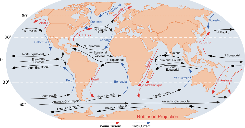 image 4
High Pressure Zone:
Low Pressure Zone:
Natural Resources
Coal, iron ore, petroleum, natural gas, mercury, tin, tungsten, antimony, manganese, molybdenum, vanadium, magnetite, aluminum, lead, zinc, rare earth elements, uranium, hydropower potential (world's largest)[13]
Energy
Electricity - production: 3.446 trillion kWh (2009 est.)
Electricity - consumption: 3.438 trillion kWh (2008 est.)
Electricity - exports: 17.39 billion kWh (2009 est.)
Electricity - imports: 11.38 billion kWh (2009 est.) Oil - production: 4.273 million bbl/day (2010 est.)
Oil - consumption: 9.189 million bbl/day (2010 est.) Oil - exports: 480,600 bbl/day (2009 est.)
Oil - imports: 4.753 million bbl/day (2009 est.)
Oil - proved reserves: 20.35 billion bbl (1 January 2011 est.)
Natural gas - production: 94.41 billion cu m (2010 est.)
Natural gas - consumption: 106.7 billion cu m (2010 est.)[14]
Natural hazards
Natural Hazards: Frequent typhoons (about five per year along southern and eastern coasts); damaging floods; tsunamis; earthquakes; droughts; land subsidence volcanism: China contains some historically active volcanoes including Changbaishan (also known as Baitoushan, Baegdu, or P'aektu-san), Hainan Dao, and Kunlun although most have been relatively inactive in recent centuries [15]
Japan
==Longitude and Latitude Ranges== 35°N 139°E
==Longitude and Latitude Ranges== 35°N 139°E in Tokyo, Japan
The bodies of water that surround Japan are the Pacific Ocean to the east, the Philippine and East China seas to the south, and the Sea of Japan to the west.
The Japanese islands are the upper portions of vast mountains belonging to what is sometimes called the Circum-Pacific Ring of Fire. The Mountains cover about 75% of Japan. The Plains cover about 25% of Japan.
Average Monthly Temperature
Highs: January-52 degrees February-52 degrees March-54 degrees April- 68 degrees May-73 degrees June-75 degrees July-84 degrees August-87 degrees September-82 degrees October-70 degrees November-60 degrees December-54 degrees
Lows: January-35 degrees February-36 degrees March-38 degrees April-52 degrees May-58 degrees June-68 degrees July-71 degrees August-74 degrees September-69 degrees October-56 degrees November-48 degrees December-37 degrees
Climate Zone
Climate:
Prevailing Winds:
Ocean Currents:
High Pressure Zone:
Low Pressure Zone:
Russia
Longitude and Latitude Ranges
Large Bodies of Water
Bordering Oceans
Major Topographic Features
Average Monthly Temperature
Highs:
Lows:
Average Monthly Rainfall:
Climate Zone
Climate:
Prevailing Winds:
Ocean Currents:
High Pressure Zone:
Low Pressure Zone:
Earth Science 7 Regions Link
Earth Science 7-Global Regions Index
Citations
http://www.indexmundi.com/china/elevation_extremes.html
http://lasauniversity.tripod.com/water.html
http://travel.nationalgeographic.com/travel/continents/asia/
http://www.infoplease.com/ipa/A0001763.html
http://itouchmap.com/latlong.html
http://www.china.org.cn/english/environment/222905.html
https://www.cia.gov/library/publications/the-world-factbook/geos/countrytemplate_ch.html