Difference between revisions of "Asia earth science 5"
(→Rock Type) |
|||
| Line 320: | Line 320: | ||
==Rock Type== | ==Rock Type== | ||
| + | |||
| + | |||
| + | Lithology refers to hard and loose rocks and deposits of various stages of continental lithogenesis, which form the surface layer involved in active daily and annual thermo-hydrologic cycles. These rocks and deposits contribute matter to the turnover of biogeochemical processes and soil formation, and deliver substances transported by runoff. | ||
| + | |||
| + | The lithogenic basis constitutes parent rocks from which soils arise. These rocks form a layer of the geological hard and/or loose rocks, which is the underlying soil profile and is not influenced by soil-forming processes. Many studies have been carried out to distinguish the characteristics of parent rocks from those of soils. Thus the chemical and mineralogical composition of parent rocks, which plays an important role in ecosystems functioning, is well-known. | ||
| + | |||
| + | Phenacite is a rare beryllium mineral which is a silicate that has trigonal symmetry. | ||
| + | Crystals are said to be rare ... flattened rhombohedral to tabular shape(often lens like), found in Minas Gerais, Zimbabwe, Russia and Colorado. Also short prismatic slender wands, primarily from Madagascar.The colour ranges from colourless and white but may be tinted pink, yellow and brown.It has been confirmed that the phenacite from the different countries does have different properties and unique energetic vibrations alongside the general metaphysical blueprint.It is regarded at this time as being the carrier of the Highest Vibration of any known crystal ... a powerful activator of the upper chakras, especially the crown and those above the head 8-14 chakras. All types of phenacite help to activate the "light body" and to be able to experience existence in the higher dimensions. Also said to have initiated contact with Light Masters and Angelic beings. It clears, cleanses and activates all chakras being also able to purify body structure, energy centers and pathways. | ||
=''Earth Science 7 Regions Link''= | =''Earth Science 7 Regions Link''= | ||
Revision as of 13:05, 22 February 2012
Contents
- 1 Asia
- 2 China
- 2.1 Longitude and Latitude Ranges
- 2.2 Location
- 2.3 Area
- 2.4 Population
- 2.5 Large Bodies of Water
- 2.6 Bordering Oceans
- 2.7 Major Topographic Features
- 2.8 Elevation Range
- 2.9 Average Monthly Temperature (Fahrenheit) & Rainfall
- 2.10 Climate Zone
- 2.11 Natural Resources
- 2.12 Energy
- 2.13 Natural hazards
- 2.14 Mining
- 2.15 Rock Types
- 3 Japan
- 4 Russia
- 5 Earth Science 7 Regions Link
- 6 Citations
Asia
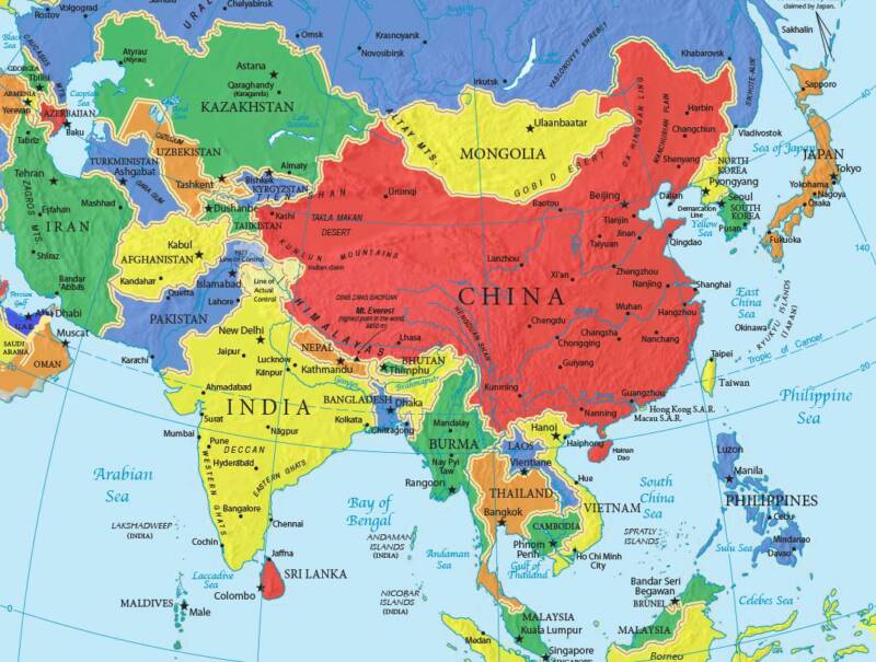 image 1
Countries of Asia
Afghanistan/ Armenia/ Azerbaijan /Bahrain/ Bangladesh/ Bhutan/ Brunei/ Cambodia/ China/ Georgia/ India/ Indonesia/ Iran/ Iraq/ Israel/ Japan/ Jordan/ Kazakhstan/ Kuwait/ Kyrgyzstan/ Laos/ Lebanon/ Malaysia/ Maldives/ Mongolia/ Myanmar/ Nepal/ "North Korea"/ Oman/ Pakistan/ Philippines/ Qatar/ Russia/ "Saudi Arabia"/ Singapore/ "South Korea"/ "Sri Lanka"/ Syria/ Tajikistan/ Thailand/ Timor-Leste/ Turkey Turkmenistan/ "United Arab Emirates"/ Uzbekistan/ Vietnam/ Yemen/
China
 image 2
Longitude and Latitude Ranges
Latitude Range: 49 degrees N-- 19 degrees N Longitude Range: 74 degrees E-- 119 degrees E [2]
Location
Eastern Asia, bordering the East China Sea, Korea Bay, Yellow Sea, and South China Sea, between North Korea and Vietnam[3]
Border countries: Afghanistan 76 km, Bhutan 470 km, Burma 2,185 km, India 3,380 km, Kazakhstan 1,533 km, North Korea 1,416 km, Kyrgyzstan 858 km, Laos 423 km, Mongolia 4,677 km, Nepal 1,236 km, Pakistan 523 km, Russia (northeast) 3,605 km, Russia (northwest) 40 km, Tajikistan 414 km, Vietnam 1,281 km[4]
Regional borders: Hong Kong 30 km, Macau 0.34 km Coastline: 14,500 km[5]
Area
Total Land Area: 9,596,961 sq km
Water: 27,060 sq km[6]
Population
Population: 1,336,718,015 (July 2011 est.)[7]
Large Bodies of Water
Yangtze River-- 3722 miles long Tonle Sap Lake-- 3860 sq. mi
Bordering Oceans
Pacific Ocean
Major Topographic Features
Qinghai-Tibet Plateau --4000 meters above sea level
Mt. Everest-- 8448 meters above sea level
Mongolia Plateau
Loess Plateau
Yunnan-Guizhou Plateau
Tarim Basin
Junggar Basin
Sichuan Basin
Northeast Plain
North China Plain
Yangtze Plain
Himalaya Mountain Range [8]
Elevation Range
8448 meters above sea level--- 154 meters below sea level [9]
Average Monthly Temperature (Fahrenheit) & Rainfall
      Highs:    Lows:   Rainfall(inches):
Jan. :34         15       0.1
Feb. :39         19       0.2
Mar. :52         30       0.4
Apr. :67         45       1.0
May. :79         55       1.1
Jun. :86         64       2.8
Jul. :87         70       6.9
Aug. :85         68       7.2
Sep. :78         57       1.9
Oct. :66         45       1.7
Nov. :50         31       0.2
Dec. :37         19       0.1
Climate Zone
 image 3
Climate: Köppen Climate Classification System
In A - Moist Tropical Climates are known for their high temperatures year round and for their large amount of year round rain.
B - Dry Climates are characterized by little rain and a huge daily temperature range. Two subgroups, S - semiarid or steppe, and W - arid or desert, are used with the B climates.
C - In Humid Middle Latitude Climates land/water differences play a large part. These climates have warm,dry summers and cool, wet winters.
D - Continental Climates can be found in the interior regions of large land masses. Total precipitation is not very high and seasonal temperatures vary widely.
E - Cold Climates describe this climate type perfectly. These climates are part of areas where permanent ice and tundra are always present. Only about four months of the year have above freezing temperatures.
Beijing, China is classified as Level C
The parts of China in the Himalayan Mountains are cold because it is at such a high elevation. The rest of China is at sea level so it is at an average temperture. The deep basins are also cooler because they provide shade.
China has the East China sea on its east side. Thus the East side gets more rain and therefore the temperture gets cooler.
Prevailing Winds: In North China, there is the South Westerlies and in the South there is the North Easterlies.[12]
Ocean Currents:In the Southeast China has the Kuroshio warm current.  image 4
High Pressure Zone:
Low Pressure Zone:
Natural Resources
Coal, iron ore, petroleum, natural gas, mercury, tin, tungsten, antimony, manganese, molybdenum, vanadium, magnetite, aluminum, lead, zinc, rare earth elements, uranium, hydropower potential (world's largest)[13]
Energy
Electricity - production: 3.446 trillion kWh (2009 est.)
Electricity - consumption: 3.438 trillion kWh (2008 est.)
Electricity - exports: 17.39 billion kWh (2009 est.)
Electricity - imports: 11.38 billion kWh (2009 est.) Oil - production: 4.273 million bbl/day (2010 est.)
Oil - consumption: 9.189 million bbl/day (2010 est.) Oil - exports: 480,600 bbl/day (2009 est.)
Oil - imports: 4.753 million bbl/day (2009 est.)
Oil - proved reserves: 20.35 billion bbl (1 January 2011 est.)
Natural gas - production: 94.41 billion cu m (2010 est.)
Natural gas - consumption: 106.7 billion cu m (2010 est.)[14]
Natural hazards
Natural Hazards: Frequent typhoons (about five per year along southern and eastern coasts); damaging floods; tsunamis; earthquakes; droughts; land subsidence volcanism: China contains some historically active volcanoes including Changbaishan (also known as Baitoushan, Baegdu, or P'aektu-san), Hainan Dao, and Kunlun although most have been relatively inactive in recent centuries [15]
Mining
Petroleum (10 000 tons) 249097.9
Natural Gas (100 million cu.m) 25292.6
Coal (100 million tons) 3373.4
Iron (Ore, 100 million tons) 217.6
Manganese (Ore, 10 000 tons) 29658.5
Chromite (Ore, 10 000 tons) 537.1
Vanadium (Ore, 10 000 tons) 1304.9
Titanium (10 000 tons) 21385.0
Copper (Metal, 10 000 tons) 2929.0
Lead (Metal, 10 000 tons) 1314.7
Zinc (Metal, 10 000 tons) 4151.5
Bauxite (Ore, 10 000 tons) 72069.0
Nickel (Metal, 10 000 tons) 278.3
Tungsten (WO3, 10 000 tons) 291.6
Tin (Metal, 10 000 tons) 176.8
Molybdenum (Metal, 10 000 tons) 263.1
Antimony (Metal, 10 000 tons) 84.1
Gold (Metal, tons) 2075.1
Silver (Metal, tons) 37430.1
Rare Earths (REO, 10 000 tons) 2093.6
Magnesite Ore (Ore, 10 000 tons) 149660.4
Fluorspar Mineral (Mineral, 10 000 tons) 2835.0
Pyrite Ore (Ore, 10 000 tons) 194987.9
Phosphorus Ore (Ore, 10 000 tons) 389393.3
Potassium KCl (KCl, 10 000 tons) 27228.9
Sodium Salt NaCl (NaCl, 100 million tons) 1828.7
Mirabilite (Na2SO4, 100 million tons) 70.1
Barite Ore (Ore, 10 000 tons) 9839.0
Silicon Materials For Glass Ore (Ore, 10 000 tons) 124280.0
Graphite Mineral (Crystal) (Mineral, 10 000 tons) 5277.4
Talc Ore (Ore, 10 000 tons) 9387.0
Kaolin Ore (Ore, 10 000 tons) 55272.0 [16]
Rock Types
 image 7
Sedimentary Rocks form in China's rivers.(Yangtze River,Tonle Sap Lake)
Metamorphic rocks form near the Himalayan mountain range.
Igneous rocks form near china's volcano's.
Japan
==Longitude and Latitude Ranges== 35°N 139°E
==Longitude and Latitude Ranges== 35°N 139°E in Tokyo, Japan
The bodies of water that surround Japan are the Pacific Ocean to the east, the Philippine and East China seas to the south, and the Sea of Japan to the west.
The Japanese islands are the upper portions of vast mountains belonging to what is sometimes called the Circum-Pacific Ring of Fire. The Mountains cover about 75% of Japan. The Plains cover about 25% of Japan.
Average Monthly Temperature
Highs: January-52 degrees February-52 degrees March-54 degrees April- 68 degrees May-73 degrees June-75 degrees July-84 degrees August-87 degrees September-82 degrees October-70 degrees November-60 degrees December-54 degrees
Lows: January-35 degrees February-36 degrees March-38 degrees April-52 degrees May-58 degrees June-68 degrees July-71 degrees August-74 degrees September-69 degrees October-56 degrees November-48 degrees December-37 degrees
Climate Zone
Climate:
Prevailing Winds:
Ocean Currents:
High Pressure Zone:
Low Pressure Zone:
Mining
Rock Types
Russia
Longitude and Latitude Ranges
The latitude of Russia is 41°13′14″N to 81°50′35″N The longitude of Russia is 19°38'E to 169°01′W
Large Bodies of Water
The largest body of water in Asian Russia is Lake Baikal (31,494 km²). Two more large bodies of water in Russia is the Black Sea and the Gulf of Finland. The last two big bodies of water in Russia are the Bering Sea and the Sea of Okhotsk.
Bordering Ocean
Russia is one of the few countries in the world that have three oceans bordering it. One of which is the freezing cold Arctic Ocean. Another ocean is Atlantic ocean. The last ocean is the Pacific Ocean. The Pacific Ocean is the biggest ocean in the entire world.
Major Topographic Features
Most of the major rivers in Russia flow from north to south. The rivers also become wider and deeper the further you progress east. They are also prone to heavy flooding during the spring thaw and autumn wet seasons. The Berezina River, flows for 380 miles (610km). It rises in Belarus and flows generally south past Borisov and Bobruysk into the Dneper River. It is navigable for most of its length. The Bug River flows for 480 miles (770km), rising in the Volhynian-Podolian hills in the western Ukraine. It flows north along the Polish-Ukrainian and Polish-Belarussian borders past Brest and then northwest through Poland to join the Vistula River near Warsaw. It is linked with the Dnepr by the Dnepr-Bug Canal via the Pina River and with the Niemen by the Augustov Canal via the Narva River. The Bug is also known as the Western Bug.The Daugava or Western Dvina is a river rising in the Valdai Hills flowing through Russia and Belarus, to drain into the Gulf of Riga, an arm of the Baltic Sea at Riga in Latvia. The total length of the river is 633 miles (1020km). It is connected by canal with the Berezina and Dnepr rivers. The Dnepr River flows for 1,430 miles (2,300km) through Belarus and the Ukraine. One of the longest rivers in Europe, it rises in the Valdai Hills, west of Moscow. It flows south through Belarus past Smolensk and Mogilev. It then travels through the Ukraine, past Kiev, Cherkasy, Kremenchug, Dneprpetrovsk, Zaporizhya, Nikopol, and Kherson into the Black Sea. Between Kremenchug and Nikopol the Dneper makes a big bend to the east. Since the construction in 1932 of the Dniprohes dam the Dnepr is navigable for virtually its entire course. Its tributaries include the Berezina, the Pripyat, and the Inhulets from the west and the Sozh, the Desna, the Orel, and the Samara from the east. The Dnepr is linked by canal with the Western Bug. The river Dniester, flows for 840 miles (1,352 km). It rises in the Ukraine, near the border with Poland, and flows toward the Black Sea. For a short while it marks the border of the Ukraine. It leaves this region and then flows through the Ukraine to the Black Sea. The Dniester, which rises in the Carpathians, within the territory of Galicia, becomes navigable at Sambor, and receives on the right the Stryj, the Swica, the Lomnica and the Bystrzyca, and on the left the Lipa, the Strypa, the Sereth and the Zbrucz. The Don is one of the major rivers of Russia. It rises near Tula, southeast of Moscow, and flows for a distance of about 1,220 miles (1,950km) to the Sea of Azov. From its source, the river first flows southeast to Voronezh, then southwest to its mouth. The main city on the river is Rostov on Don, its main tributary the Donets. At its easternmost point, the Don comes near the Volga. The two rivers are connected by the Volga-Don Canal whose length is 65 miles (105km). The Donets River rises in the Central Russian Upland, flowing south and then east through Russia and Ukraine for some 650 miles (1,050km). It rises northeast of Belgorod, which it then passes and flows generally southeast along the northern Donets Basin industrial region to join the Don River below Konstantinovsk. The Kuban River in southwestern Russia flows for 563 miles (906km) in length. It rises from glaciers on Mount Elbrus in the Greater Caucasus and flows north through narrow gorges, with many rapids, to the Stavropol Upland, where it turns westward in a broad, marshy floodplain to enter the Sea of Azov. Much of its water is diverted for irrigation. The river is navigable for most of its length.
Average Monthly Temperature
Monthly averages °F | °C
January Avg Low: -8° Avg High: -5° Avg precip: 3.99 cm February Avg Low: -9° Avg High: -4° Avg precip: 3.25 cm March Avg Low: -5° Avg High: 2° Avg precip: 2.72 cm April Avg Low: 2° Avg High: 11° Avg precip: 2.42 cm May Avg Low: 8° Avg High: 18° Avg precip: 3.92 cm June Avg Low: 12° Avg High: 22° Avg precip: 5.93 cm July Avg Low: 14° Avg High: 24° Avg precip: 5.56 cm August Avg Low: 12° Avg High: 22° Avg precip: 5.64 cm September Avg Low: 8° Avg High: 15° Avg precip: 4.61 cm October Avg Low: 3° Avg High: 8° Avg precip: 4.99 cm November Avg Low: -3° Avg High: 0° Avg precip: 3.82 cm December Avg Low: -8° Avg High: -4° Avg precip: 3.57 cm
Climate Zone
CLIMATE: Russia is both cold and warm depending on the time of year and the location in Russia. There is a cold and dry part of Russia called Siberia. Near the Black Sea in Russia it is warm and tropical.
PREVAILING WINDS:
OCEAN CURRENTS: On the eastern side of Russia there is a warm water ocean current coming from the Gulf of Mexico making the land which is very cold heat up causing fog inward on the land.
HIGH PRESSURE ZONES: The high pressure zone is coming inland so it is not as cold.
LOW PRESSURE ZONE: Russia is a low pressure zone and the winds are coming from the arctic ocean so the wind is freezing cold.
Mining
Rock Type
Lithology refers to hard and loose rocks and deposits of various stages of continental lithogenesis, which form the surface layer involved in active daily and annual thermo-hydrologic cycles. These rocks and deposits contribute matter to the turnover of biogeochemical processes and soil formation, and deliver substances transported by runoff.
The lithogenic basis constitutes parent rocks from which soils arise. These rocks form a layer of the geological hard and/or loose rocks, which is the underlying soil profile and is not influenced by soil-forming processes. Many studies have been carried out to distinguish the characteristics of parent rocks from those of soils. Thus the chemical and mineralogical composition of parent rocks, which plays an important role in ecosystems functioning, is well-known.
Phenacite is a rare beryllium mineral which is a silicate that has trigonal symmetry. Crystals are said to be rare ... flattened rhombohedral to tabular shape(often lens like), found in Minas Gerais, Zimbabwe, Russia and Colorado. Also short prismatic slender wands, primarily from Madagascar.The colour ranges from colourless and white but may be tinted pink, yellow and brown.It has been confirmed that the phenacite from the different countries does have different properties and unique energetic vibrations alongside the general metaphysical blueprint.It is regarded at this time as being the carrier of the Highest Vibration of any known crystal ... a powerful activator of the upper chakras, especially the crown and those above the head 8-14 chakras. All types of phenacite help to activate the "light body" and to be able to experience existence in the higher dimensions. Also said to have initiated contact with Light Masters and Angelic beings. It clears, cleanses and activates all chakras being also able to purify body structure, energy centers and pathways.
Earth Science 7 Regions Link
Citations
http://www.indexmundi.com/china/elevation_extremes.html
http://lasauniversity.tripod.com/water.html
http://travel.nationalgeographic.com/travel/continents/asia/
http://www.infoplease.com/ipa/A0001763.html
http://itouchmap.com/latlong.html
http://www.china.org.cn/english/environment/222905.html
https://www.cia.gov/library/publications/the-world-factbook/geos/countrytemplate_ch.html
http://www.worldclimate.com/cgi-bin/grid.pl?gr=N35E139
http://wiki.answers.com/Q/What_are_the_surrounding_bodies_of_water_in_Japan
http://www.nationsencyclopedia.com/Asia-and-Oceania/Japan-TOPOGRAPHY.html
http://www.weather.com/outlook/travel/vacationplanner/vacationclimatology/monthly/JAXX0085
http://www.allcountries.org/china_statistics/1_12_major_mineral_basic_reserves.html