Difference between revisions of "Earth Science 7-Africa2"
| Line 200: | Line 200: | ||
== Climate Zones(Top to Bottom) == | == Climate Zones(Top to Bottom) == | ||
| − | |||
http://koeppen-geiger.vu-wien.ac.at/pics/map.jpg | http://koeppen-geiger.vu-wien.ac.at/pics/map.jpg | ||
| − | + | <ref name="Climate">http://koeppen-geiger.vu-wien.ac.at/present.htm</ref> | |
| − | + | ||
-Hot summer, summer dry, warm temperate | -Hot summer, summer dry, warm temperate | ||
| Line 225: | Line 223: | ||
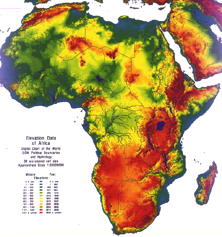
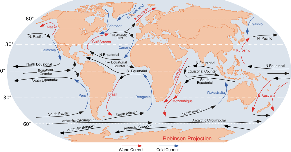
== Climate Controls == | == Climate Controls == | ||
| − | + | <ref name="Elevation map">http://www.ce.utexas.edu/prof/maidment/grad/akmansoy/niger/africa.gif</ref> | |
| − | + | <ref name="Ocean currents">http://www.physicalgeography.net/fundamentals/images/oceancurrents.gif</ref> | |
| − | + | <ref name="Wind currents">http://www.geni.org/globalenergy/library/renewable-energy-resources/world/africa/wind-africa/index.shtml</ref> | |
| − | + | <ref name="Vegetation">http://www.sbceo.k12.ca.us/%7Evms/carlton/Africa/AfricaVegetationMap.jpg</ref> | |
| − | + | ||
-The equator and the Prime Meridian pass through it causing hot temperatures | -The equator and the Prime Meridian pass through it causing hot temperatures | ||
| Line 253: | Line 250: | ||
Google Earth: Water Bodies & Latitude/Longitude | Google Earth: Water Bodies & Latitude/Longitude | ||
| − | <ref name="Climate | + | <ref name="Climate"/>- Climate Zones |
| − | + | <ref name="Elevation map"/>- Elevation Map | |
| − | + | <ref name="Ocean currents"/>- ocean currents map | |
| − | + | <ref name="Wind currents"/>- Wind currents map | |
| − | + | <ref name="Vegetation"/>- Vegetation map | |
<references/> | <references/> | ||
Revision as of 18:51, 6 November 2011
Earth Science 7-Global Regions Index
Contents
Africa
Algeria,
Angola,
Benin,
Botswana,
Burkina Faso,
Burundi,
Cameroon,
Cape Verde,
Central African Republic,
Chad,
Comoros,
Republic of Congo,
Democratic Republic of The Congo,
Cote d'Ivoire,
Djibouti,
Egypt,
Equatorial Guinea,
Eritrea,
Ethiopia,
Gabon,
The Gambia,
Ghana,
Guinea,
Guinea-Bissau,
Ivory Coast (Cote d'Ivoire),
Kenya,
Lesotho,
Liberia,
Libya,
Madagascar,
Malawi,
Mali,
Mauritania,
Mauritius,
Morocco,
Mozambique,
Namibia,
Niger,
Nigeria,
Rwanda,
Sao Tome and Principe,
Senegal,
Seychelles,
Sierra Leone,
Somalia,
South Africa,
Sudan,
Swaziland,
Tanzania,
Togo,
Tunisia,
Uganda,
Zambia,
Zimbabwe,
Latitude/Longitude
Longitude: 37°N - 37°S Latitude: 18°W - 53ºE
Elevation Range
Highest Point:
Mt. Kilimanjaro, Tanzania
5,895.1368 meters
Lowest Point: Lake Assal, Djibouti 156.0576 meters below sea level
Bodies of Water
Lakes: Chad, Nasser, Tanganyika, Victoria
Rivers: Blue Nile, Congo, Limpopo, Niger, Nile, Orange, Senegal, Volta, White Nile
Seas: Arabian, Mediterranean, Red
Topographic Features
Atlas Mountains
Nambi Desert
Great Rift Valley
Congo River Basin
Kalahari Desert
Ethiopian Highlands
Nubian Desert
Libyan Desert
Ahaggar Mountains
Sahara Desert
Qattara Depression
Jabel Toubkal
Ras Dejen
Emi Koussi
Adamwa Mountains
Cameroon Mountain
Bie Plateau
Namib Desert
Thabana Ntleyana
Margherita Peak
Mount Kenya
Bemaraha Plateau
Jos Plateau
Bordering Oceans
Atlantic Ocean and Indian Ocean
Climate Zones(Top to Bottom)
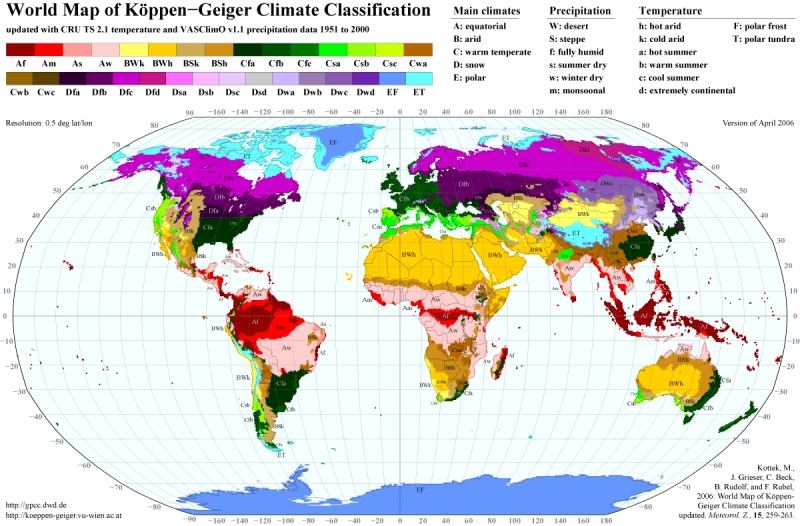
-Hot summer, summer dry, warm temperate
-Hot arid steppe
-cold arid desert
-Hot arid desert
-Hot arid steppe
-Cold arid steppe
-Hot arid desert
-Warm Temperature, fully humid, hot summer
Climate Controls
-The equator and the Prime Meridian pass through it causing hot temperatures
-The elevation reaches up to 1400 meters which is cooler than sea level
-Has many deserts which cause extreme climate changes daily and receive very little rain
-On the west coast, ocean currents are cooler, while on east coast, ocean currents are warmer
-Almost all of Africa has mild wind currents which make it hotter
-Mostly desert and jungle which means there are pretty extreme climate changes
Sources
[1]-Countries in Africa
[2]- Elevation Range
Student Atlas of the World- Topographic Features
Google Earth: Water Bodies & Latitude/Longitude
[3]- Climate Zones
[4]- Elevation Map
[5]- ocean currents map
[6]- Wind currents map
[7]- Vegetation map
- ↑ 1.0 1.1 http://www.africaguide.com/country.htm
- ↑ 2.0 2.1 http://www.worldatlas.com/webimage/countrys/af.htm
- ↑ 3.0 3.1 http://koeppen-geiger.vu-wien.ac.at/present.htm
- ↑ 4.0 4.1
- ↑ 5.0 5.1
- ↑ 6.0 6.1 http://www.geni.org/globalenergy/library/renewable-energy-resources/world/africa/wind-africa/index.shtml
- ↑ 7.0 7.1
