Difference between revisions of "Earth Science 7-Monterrey, Mexico"
| Line 1: | Line 1: | ||
'''Monterrey, Nuevo Leon, Mexico''' | '''Monterrey, Nuevo Leon, Mexico''' | ||
| − | [[Earth Science 7- Cities]] | + | 20–7E [[Earth Science 7- Cities]] |
Revision as of 19:44, 16 February 2011
Monterrey, Nuevo Leon, Mexico
20–7E Earth Science 7- Cities
Latitude/Longitude
25.40 N/100.18 W [1]
Elevation: 700 meters [1]
Major Bodies of Water:
About 180 miles from the Gulf of Mexico [1]

Contents
Climate
Climate Zone
BSh, subtropical steppe, mid-latitide dry [2]
Similar cities include: Alice Springs, Australia Earth Science 7-Alice Springs, Australia and Muscat, Oman Earth Science 7-Muscat, Oman A different city is: Fortaleza, Brazil Earth Science 7-Fortaleza, Brazil Comparison: Alice Springs, Australia, and Muscat, Oman, are similar cities to Monterrey, Mexico. Although Alice Springs is in the Southern hemisphere so hotter temperatures are during the December and January months, they are much the same to Monterrey's temperatures in the summer. Alice Springs, Muscat, and Monterrey, are all in the center of a large land mass and they are all dry. Muscat, Oman, is at the same latitude area as Monterrey and Alice Springs is similar latitude except on the Southern side of the Equator. Fortaleza, Brazil, has a very different climate than Monterrey Mexico. First of all, the elevation is very different since Fortaleza is at sea level and Monterrey is in the mountains. Second, Fortaleza is next to the Atlantic Ocean while Monterrey is in the middle of Mexico. Fortaleza is highly tropical compared to the parch desert of Monterrey. Consequently, Fortaleza gets about 60 inches of rain each year while Monterrey gets only 23 inches. Monterrey is on average much more extreme than Fortaleza, because Fortaleza has a very small temperature range of about 5 degrees Celsius from 25.3 degrees to 30, while Monterrey has a range of about 27 degrees Celsius from 9.4 to 36.6 degrees Celsius. However, one similarity is that they both do not get snow.
Average Temperature
| Jan. | Feb | Mar. | Apr. | May | June | July | Aug. | Sept. | Oct. | Nov. | Dec. | Annual | |
|---|---|---|---|---|---|---|---|---|---|---|---|---|---|
| Average Temp. (C˚) | 14.4 | 16.5 | 20.0 | 23.4 | 25.7 | 27.3 | 27.8 | 27.9 | 25.7 | 22.1 | 17.8 | 14.9 | 22.0 |
| Average High (C˚) | 23.3 | 25.5 | 27.7 | 32 | 34.5 | 35 | 36.6 | 35 | 32 | 28.3 | 25.5 | 22 | 30 |
| Average Low (C˚) | 9.4 | 11.7 | 13.8 | 17.8 | 21 | 22.8 | 22.8 | 22.8 | 21 | 17.8 | 13.9 | 10 | 17 |
Average Precipitation
| Jan. | Feb. | Mar. | Apr. | May | June | July | Aug. | Sept. | Oct. | Nov. | Dec. | Annual | |
|---|---|---|---|---|---|---|---|---|---|---|---|---|---|
| Average Precipitation (in) | 0.7 | 0.9 | 0.6 | 1.1 | 1.6 | 2.7 | 2.4 | 3.0 | 5.9 | 3.1 | 1.0 | 0.8 | 23.8 |
| Average Days With Precipitation | 3 | 2 | 3 | 1 | 1 | 2 | 1 | 2 | 3 | 3 | 2 | 2 | 25 |
[5] There is no monthly snowfall for Monterrey, Mexico [6]
Factors that Regulate Climate
Monterrey is in the mid-latitudes, close to the 25 degree line. Since Monterrey is not very close to a large body of water, Monterrey is dry. Monterrey is very mountainous. This affects the weather because the mountains can block incoming winds, but create others as the air at the top of the mountain blows downward.
Pressure Zone
Monterrey is close the the 30 degree North latitude line, which has high pressure. Pressure is also affected by humidity, and Monterrey is not very humid. Both of these factors contribute to high pressure. However, Monterrey is also hotter than most climates, and hotter weather has lower pressure. But although there is a factor for low pressure, Monterrey generally has high pressure.
Winds
Although trade winds do travel from the North-East to the South-West in Monterrey's location, much of the winds are blocked by the Sierra Madre Oriental Mountains that surround Monterrey, Mexico.
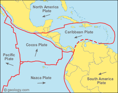
Plate Tectonics
Monterrey is about equidistant from the border of the Pacific Plate, the border of the Cocos Plate, and the border of the Caribbean Plate. For this reason, Monterrey has not had many Earthquakes.
Rocks
Monterrey is made up of mostly sedimentary rocks.

- ↑ 1.0 1.1 1.2 Monterrey, Mexico Map. Google Earth. Google.com, 12 Oct. 2010. Web. 12 Oct. 2010.
- ↑ http://www.srh.noaa.gov/jetstream/global/climate_max.htm
- ↑ http://www.worldclimate.com/cgi-bin/data.pl?ref=N25W100+1102+76393W
- ↑ http://www.climate-zone.com/climate/mexico/fahrenheit/monterrey.htm
- ↑ http://www.worldclimate.com/cgi-bin/data.pl?ref=N25W100+2100+76393W
- ↑ http://www.climate-zone.com/climate/mexico/fahrenheit/monterrey.htm