Difference between revisions of "Earth Science 7-Southeast Asia2"
| Line 311: | Line 311: | ||
The southwest monsoon prevails from May to September, when the air current reverses and the dominant flow is to the northeast. The mainland receives the bulk of its rainfall during this period. Over much of the southern Malay Peninsula and insular Southeast Asia there is little or no prolonged dry season. This is especially marked in much of the equatorial region and along the east coast of the Philippines. | The southwest monsoon prevails from May to September, when the air current reverses and the dominant flow is to the northeast. The mainland receives the bulk of its rainfall during this period. Over much of the southern Malay Peninsula and insular Southeast Asia there is little or no prolonged dry season. This is especially marked in much of the equatorial region and along the east coast of the Philippines. | ||
While the dry and wet monsoons are important in explaining rainfall patterns, so too are such factors as relief, land and sea breezes, convectional overturning and cyclonic disturbances. These factors often are combined with monsoonal effects to produce highly variable rainfall patterns over relatively short distances. While many of the cyclonic disturbances produce only moderate rainfall, others mature into tropical storms—called cyclones in the Indian Ocean and typhoons in the Pacific—that bring heavy rains and destruction to the areas over which they pass. The Philippines are particularly affected by these storms. | While the dry and wet monsoons are important in explaining rainfall patterns, so too are such factors as relief, land and sea breezes, convectional overturning and cyclonic disturbances. These factors often are combined with monsoonal effects to produce highly variable rainfall patterns over relatively short distances. While many of the cyclonic disturbances produce only moderate rainfall, others mature into tropical storms—called cyclones in the Indian Ocean and typhoons in the Pacific—that bring heavy rains and destruction to the areas over which they pass. The Philippines are particularly affected by these storms. | ||
| + | |||
| + | http://www.eepsea.cc-sea.org/images/precip.gif <ref>[http://www.google.com/imgres?q=list+showing+countries,+area,+population,+density+and+capitals+of+southeast+asia&hl=en&biw=1052&bih=784&gbv=2&tbm=isch&tbnid=tQOfomy_Ou998M:&imgrefurl=http://www.eepsea.cc-sea.org/pages/resource/sociecon.html&docid=vnsLzO3UVmYPBM&imgurl=http://www.eepsea.cc-sea.org/images/precip.gif&w=600&h=396&ei=5xbQTsmiDtDhsQK65cHeDg&zoom=1&iact=hc&vpx=701&vpy=147&dur=695&hovh=182&hovw=276&tx=159&ty=66&sig=114102442009973286785&page=6&tbnh=114&tbnw=173&start=106&ndsp=22&ved=1t:429,r:4,s:106]. </ref> | ||
(Southeast Asia on the far right and far left side of the ocean currents map) | (Southeast Asia on the far right and far left side of the ocean currents map) | ||
Revision as of 17:33, 25 November 2011
Earth Science 7-Global Regions Index
Contents
Southeast Asia
Maps
General Map of Countries

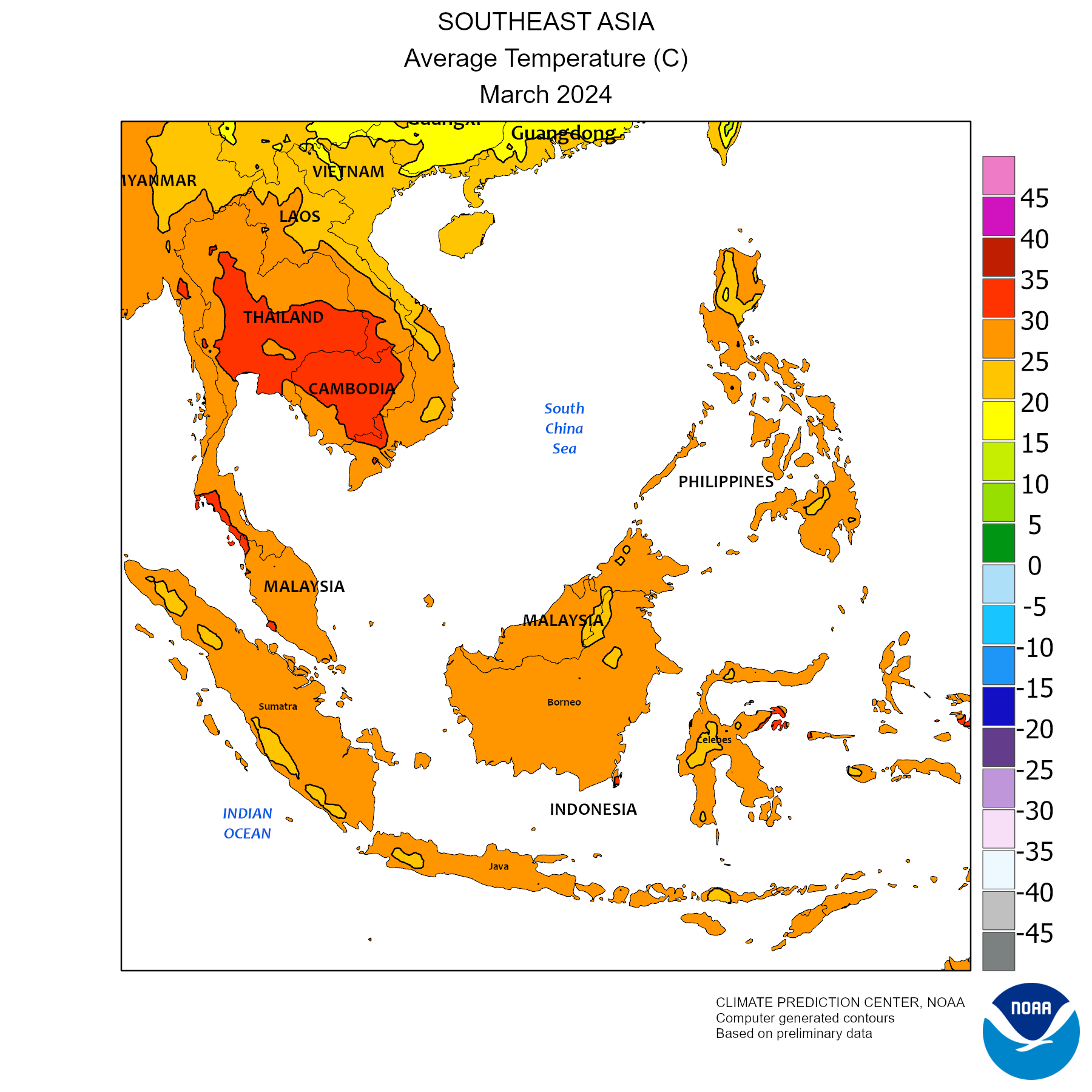
Map of Monthly Mean Temperature (°C)
| [2]
[2]
Countries
Basic Facts
Area: 1,900,000 sq. mi.
Population: 593,000,000.
Population Density: 306/sq. mi.
Approximate latitude: 28°N to 12°S
Approximate longitude: 93°E to 140°E
Time Zones: UTC+5:30 to UTC+9:00
Languages: Khasi, Khumer, Mon, Kuy, Nicobarese, Vietmanese, Santali, Hmongic Languages, Mienic Languages, Gelao, Buyang, Hlai, Zhuang, Lao, Nyaw, Thai, Atayal, Paiwan, Cebuano, Hiligaynon, Ilokano, Tagalog, Cham, Indonesian, Japanese, Malay, Sundanese, Tetum, Bodo, Burmese, Chin Languages, Dzongkha, Jingpho, Karen, Kayah, Kiranti Languages, Meitei, Mizo, Rahkine, Tibetan, and Tamil... (wow!)
Southeast Asia stretches some 4,000 miles at its greatest extent (roughly from northwest to southeast) and encompasses some 5,000,000 square miles (13,000,000 square kilometres) of land and sea, of which about 1,736,000 square miles is land.
Largest Cities
Major Bodies of Water
Rivers:
Seas and Oceans:
Natural Disasters
The Indonesian Volcanology Center has raised the alert from level II to Level III on Anak Krakatau Mt in Sunda Srait since the Sunday of September 30, 2011 following a number of volcanic quakes and increase of solfatara zone in the mountain flank.
In Philippines, June 2008 - Typhoon Fengshen sinks a ferry killing about 800 people, kills nearly 500 other people on land and leaves more than one million others homeless.
Mountains
Mountain Name , Elevation and Country
Mountain Ranges
Plateaus
Extreme Elevation Points:
Science
Vietnam astronomy news-So far in 2011, the Ho Chi Minh City Amateur Astronomy Club (HAAC) has organized three major sky parties: the Fourth Annual Astronomy Camp of HAAC in March, an evening of the 30 Nights of StarPeace in Global Astronomy Month 2011 in April, and the Total Lunar Eclipse Observation Night on June 15 and 16.
Climate
The average temperature ranges from 59.5°F to 95°F, or 15.5°C to 35°C, except for parts of Papua New Guinea which ranges from 49.5°F to 59°F, or 5.5°C to 15°C
The average rainfall ranges from 38.5 in to 195.9 in, or 975 mm to 4974 mm, except for a part of southern Papua New Guinea, which has 196 in to 294.3 in, or 4975 mm to 7474 mm
The predicted temperature increase from 1960-1990 to 2070-2100 is 3°C
All of Southeast Asia falls within the warm, humid tropics, and its climate generally can be characterized as monsoonal. It is subject to an extensive and regular monsoonal weather system (i.e., one in which the prevailing winds reverse direction every six months) that produces marked wet and dry periods in most of the region. Southeast Asia’s landscape is characterized by three intermingled physical elements: mountain ranges, plains and plateaus, and water in the form of both shallow seas and extensive drainage systems. The tropical rain belt causes additional rainfall during the monsoon season. The rain forest is the second largest on Earth. An exception to this type of climate and vegetation is the mountain areas in the northern region, where high altitudes lead to milder temperatures and drier landscape. Other parts fall out of this climate because they are desert like such as the La Paz Sand Dunes in in the province, Ilocos Norte, in the Northern Philippines and parts of Cambodia, Thailand, Laos and Myanmar which fall in the Tropical Savanna Climate region and have a dry winter season.
The water temperature is relatively warm because of the many coral reefs, which are bodies of shallow warm salt water. Indonesia has a reef area of 51,020 square kilometers. The Philippines have about 26,000 square kilometers of coral reef.
PRECIPITATION
Much of Southeast Asia receives more than 60 inches (1,500 millimetres) of rainfall annually, and many areas commonly receive double and even triple that amount. The rainfall pattern is distinctly affected by two prevailing air currents: the northeast (or dry) monsoon and the southwest (or wet) monsoon. The northeast monsoon occurs roughly from November to March and brings relatively dry, cool air and little precipitation to the mainland. As the southwestward-flowing air passes over the warmer sea, it gradually warms and gathers moisture. Precipitation is especially heavy where the airstream is forced to rise over mountains or encounters a landmass. The east coast of peninsular Malaysia, the Philippines, and parts of eastern Indonesia receive the heaviest rains during this period. The southwest monsoon prevails from May to September, when the air current reverses and the dominant flow is to the northeast. The mainland receives the bulk of its rainfall during this period. Over much of the southern Malay Peninsula and insular Southeast Asia there is little or no prolonged dry season. This is especially marked in much of the equatorial region and along the east coast of the Philippines. While the dry and wet monsoons are important in explaining rainfall patterns, so too are such factors as relief, land and sea breezes, convectional overturning and cyclonic disturbances. These factors often are combined with monsoonal effects to produce highly variable rainfall patterns over relatively short distances. While many of the cyclonic disturbances produce only moderate rainfall, others mature into tropical storms—called cyclones in the Indian Ocean and typhoons in the Pacific—that bring heavy rains and destruction to the areas over which they pass. The Philippines are particularly affected by these storms.

(Southeast Asia on the far right and far left side of the ocean currents map)

Map Showing Prediction of Climate Changes On Earth From 1980-2100 (120 years)

![[1]](http://www.google.com/imgres?q=southeast+asia&hl=en&gbv=2&biw=1113&bih=749&tbm=isch&tbnid=t_fIyG3k_-zsNM:&imgrefurl=http://wikitravel.org/en/Southeast_Asia&docid=vy7ZB86QLW6E1M&imgurl=http://wikitravel.org/upload/shared//thumb/2/21/Map_of_Southeast_Asia.png/400px-Map_of_Southeast_Asia.png&w=400&h=353&ei=_eq2TtGkKqXisQLRgvjNAw&zoom=1&iact=hc&vpx=105&vpy=188&dur=17&hovh=211&hovw=239&tx=137&ty=125&sig=102569257010269787892&page=1&tbnh=153&tbnw=173&start=0&ndsp=17&ved=1t:429,r:0,s:0)
![[5]](http://old.japanfocus.org/data/tibet.w.chi.rivers.jpg)
![[6]](http://3.bp.blogspot.com/_QH_mtdTQUk8/S-rPqp7YCEI/AAAAAAAAAAw/XTMAR3RwgHc/S1600-R/map+Southeast+Asia.jpg)
![[9]](http://www.google.com/imgres?q=list+showing+countries,+area,+population,+density+and+capitals+of+southeast+asia&hl=en&biw=1052&bih=784&gbv=2&tbm=isch&tbnid=tQOfomy_Ou998M:&imgrefurl=http://www.eepsea.cc-sea.org/pages/resource/sociecon.html&docid=vnsLzO3UVmYPBM&imgurl=http://www.eepsea.cc-sea.org/images/precip.gif&w=600&h=396&ei=5xbQTsmiDtDhsQK65cHeDg&zoom=1&iact=hc&vpx=701&vpy=147&dur=695&hovh=182&hovw=276&tx=159&ty=66&sig=114102442009973286785&page=6&tbnh=114&tbnw=173&start=106&ndsp=22&ved=1t:429,r:4,s:106)